Depending on where you are in the Appalachian Mountains, the “High Peaks” can be those over four, five, or even six thousand feet in elevation. There is also a tendency to sometimes think that these are the premier peaks, and the only ones worth hiking. But despite my own personal guilt of sometimes thinking of the same way, the truth is that in the big scheme of things, even the higher Appalachian Mountains are a pretty lowly bunch. That said, another truth is that the measure of a mountain's worth can be based on many things other than its elevation. Some people hike or climb mountains based on their prominence or their isolation. There is even a dedicated group of people who collect county highpoints, that is the highest point of every county they can visit, no matter how high or low it is. Yet others base their interest on more subjective or aesthetic criteria, like a mountain's appearance, it's difficulty, or perhaps most often, on how good the views from the top are. Some people have yet other reasons. Actually, I like to think I usually give all of these things, and more, their due consideration.
 |
| Peak 2310 |
While I can’t deny that I like climbing peaks that are on a list of the highest or most prominent in a region, the ones I feel most drawn to are those that have great views. If the peak itself is scenic or dramatic in its own appearance, that is another big plus. And if the route up it is steep, challenging, and fun, then that is yet another great appeal. While the higher peaks often do have all of these qualities in spades, they are not exclusive to them by any means, and many lower mountains can also have these same qualities. Such is the case with unnamed Peak 2310 and the nearby and slightly higher Pinnacle.
These two lowly peaks are part of a thirty mile long line of similarly elevated prominences that form the western front of the Blue Ridge from Glasgow to Vesuvius, and average 1,000 feet or more lower than the summits that form the true crest of this section of the range. Despite that, most of them are rather steep, pointy, and rugged. In fact, while these low peaks don’t show up on the more common peakbagging lists, nine of them rank in the overall steepest 100 peaks in the state. Four of them, including Peak 2310 and Pinnacle, are in the top 50. There is no doubt that they are true peaks in their own right, despite the fact that my desk at home in Wytheville where I am writing this is almost identical in elevation to Peak 2310 - which happens to rank as the 945th highest peak in the state. Most also have the distinction of being trail-less, and I would hazard to guess rarely visited - at least by hikers. I certainly haven’t encountered anyone else during my treks in the area. I first visited these two peaks on separate hikes back in early 2012, first doing Pinnacle and Target Hill, then climbing Peak 2310 and Three Sisters Knobs a couple months later. Each of the two this post focuses on had the distinction of being the best of the two peaks I climbed on each trip, and I knew I wanted to come back again sometime, hopefully with a friend to show them off to. My buddy +David Socky was up to the challenge, as usual, and we picked a nice, clear Winter day to meet up.
 |
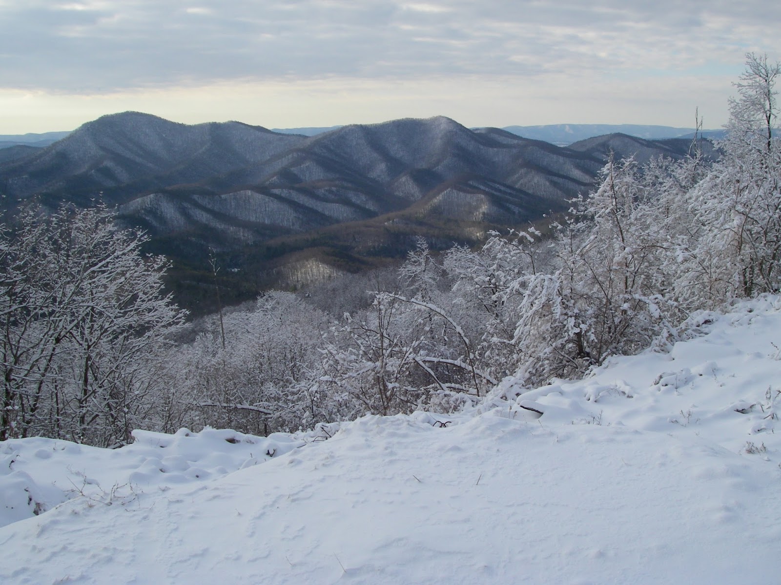
| Pinnacle |
Sticking with the route I used the first time, we headed up a gated Forest Service road that leads into the Davidson Run drainage, then veered off of it onto the western ridge. This climbs east, then northeast to the top. This is entirely off-trail, and while it is a bit brushy in spots and there are a few briers, overall the bushwhacking is not too bad. The need to curse is only sporadic. Along the way on the uppermost several hundred vertical feet, however, there are a number of rock outcrops with fun scrambles and great views ranging from south to west to northwest. Some of the peaks visible include Three Sisters Knobs and Apple Orchard Mountain in the contiguous Blue Ridge. Most of the views, however, are of peaks across the Great Valley in the Alleghenies, like Short Hills, the impressive cone of Sugarloaf Mountain, Big House and Little House Mountains, Big Butt, and Jump Mountain. Once on top of this lowly 2,310’ peak, there is also a view of more Blue Ridge peaks, including Pinnacle, Bluff Mountain, and the 4,000 Footer of Rocky Mountain. All in all, it is surprisingly fun and impressive for a mountain whose elevation is slightly lower than a significant portion of the town I live in and about the same as my apartment. We went down the more northerly of the two western ridges. It doesn’t have any real views but is easier going and makes for a nice loop.
 |
| Dave scrambling up the west ridge of Peak 2310 |
 |
| The scrambling continues |
 |
| Big Butt and Jump Mountain from Peak 2310, awesome hikes themselves. |
Once we got back to the car, before heading for Pinnacle, we crossed the road and did a fairly quick and easy hike up Brady Hill. This was uneventful other than Dave getting rather bloodied and cut up by some wicked thorns near the very beginning. There weren’t any views from this 1,529’ mountain, but it did have some nice open woods and was a new ranked peak for me - Number 1,446 out of 1,615 total peaks in the Virginia elevation rankings to be exact. Neither the Virginia 1ers, nor the Virginia Highest 1,500 are lists I aspire to make much progress on…
We drove another mile-and-a-half up the road to the start of the old, now abandoned Belle Cove Trail to begin the trek up Pinnacle. The information I have been able to find indicates that this trail was devastated as a result of a week long period of sustained and heavy rain that occurred over a large area the central and northern Blue Ridge June of 1995 and caused a lot of flooding and a considerable number of landslides in the mountains. It never was reopened, but the lower end still makes a good approach trail for climbing Pinnacle. I assume that one of the neatest features of Pinnacle is a direct result of that same weather system nearly twenty years ago. About a mile up the trail is a tiny tributary of Belle Cove Branch that drains part of Pinnacle’s west side. It is very narrow and confined in a steep-sided ravine, but if one follows it upstream for about 250 yards, it leads to the base of a small but genuine Adirondack-like slide on the north side of Pinnacle’s major southwest ridge. The size of the small pine trees now growing back would seem to agree about the age of the slide. Here a 250 yard long and 50-100 feet wide section of the mountain shed its surface down to the underlying bedrock, taking the trees and soil away. I was very excited to find this open slide on my bushwhack up Pinnacle in January of 2012. It made a great climb with awesome views that got better and better the higher I got, and made me feel like I was in the Adirondacks. The slope is moderately steep, but in dry conditions has good footing, and there is no bushwhacking since it is mostly open - at least for a few more years anyway - being mostly bare rock and loose cobbles. Unfortunately, it wasn’t quite as much fun when Dave and I did it. There was just enough snow and ice on the slide to make it treacherous, but yet not enough to justify breaking out our microspikes. The result was that we clung to its edges, partly in the trees and shrubs. But it only took a step or two out into the open to again enjoy the great views to the northwest, where House Mountain in particular is very prominent. Too soon, the slide narrows and ends, and it is very obvious the exact spot the slide started, there even being a small headwall of sorts.
 |
| This little gorge and unnamed tributary of Belle Cove Creek leads to a great slide on the southwest ridge of Pinnacle. |
 |
| I was excited to find this open slide on my first bushwhack up Pinnacle. It made a great climb with awesome views that got better and better the higher I got and made me feel like I was in the Adirondacks |
 |
| On this visit, there was just enough snow and ice on the slide to make it a little treacherous, but not enough to justify putting on our microspikes - so we ended up hugging the edge for better footing. |
 |
| Little House Mountain in front of Big House Mountain, seen from the slide on Pinnacle. |
From this point, we continued southward and perpendicular a short distance farther until we hit the crest of the peaks main southwest ridge. From here on to the top, there are a number of outcrops on the rocky ridge that provide some easy but fun scrambling and more expansive views than the slide offers. One of the first is a great view south of the conical form of Peak 2310. Continuing higher, from various points along the way, there are views in most directions that take in such sights as Apple Orchard Mountain, Purgatory Mountain, The Knob, Short Hills, a very impressive looking Sugarloaf Mountain,Target Hill, Silas Knob, and Big Rocky Row among them. All in all, it is as rewarding and challenging a climb as almost any of Virginia’s 4,000 Footers. Just like Peak 2310, and unlike more than a few of the 4,000 Footers, there is no doubt where the exact summit of this pointy peak lies. We touched a foot to it, enjoyed some more views while we had a snack, then headed down the north ridge to a yet a couple more viewpoints. At the last of these, and around the 2,000 foot elevation, we deviated from my previous descent route when I was also going after Target Hill, and headed down a minor ridge in a northwesterly, then westerly direction to a saddle crossed by an old woods road a thousand feet lower. From here it was a mostly easy walk back to our starting point and the end of another great adventure in the mountains of Virginia.
 |
| Scrambling on Pinnacle |
 |
| An overlook near the top of Pinnacle |
 |
| To see the topo map larger on this site, click on the map. Or click here to see a larger interactive version on Gmap4. |
 |
| Elevation profile for Peak 2310 and Brady Hill |
 |
| Elevation profile for Pinnacle |
Hike stats:
Peak 2310 and Brady Hill - 4.85 miles, 2,220' cumulative elevation gain
Pinnacle - 4 miles, 1,701' cumulative elevation gain
More pics:
Resources:
Trailhead coordinates for Peak 2310: 37.6619, -79.4204
Trailhead coordinates for Pinnacle: 37.6799, -79.4067
created with Chrome OS, Android, and various webapps