Showing posts with label rock formations. Show all posts

Sunday, April 14, 2013

Middle Knob And The Great Channels - Maze In The Sky


I knew about the existence of one of the neatest places in Virginia for a long time before I was able to actually go there, despite the fact the trailhead was only an hour away. The Great Channels are a maze-like system of 20-40 feet deep interconnected crevices between huge sandstone blocks on top of the Clinch Mountain peak of Middle Knob. They have somewhat of the feel, on a small scale, of a cross between a Utah slot canyon and a cave. The moss on the walls, and the way the light filters down between the rock walls, sometimes coloring them red, adds a distinct enchantment to this small but rather unique area.

I first learned about this wonderful place sometime after the Nature Conservancy bought the five thousand acre tract containing it in 2004. Even then, with TNC wanting to preserve its pristine nature, it was not open to the public until 2008, when they sold it to the State of Virginia. Information on the best way to get to the Channels was sketchy at first, and required for some exploratory hiking on my part to get to them from the one public access point in Poor Valley - and it required a 10 mile hike with 2,600 feet of elevation gain. I wasn’t even sure of just exactly where they were even located on Middle Knob.


I've now been up there several times since that first visit, and it has become yet another favorite place of mine, well worth far more effort to get to - but the last few hikes have been much easier since the opening of a second trailhead on Route 80 at Hayters Gap, on the crest of Clinch Mountain at 3,017 feet. That’s the way +Leanne and I went today. It only requires a six-and-a-half mile hike with 1,200 feet of elevation gain from here, a small price to pay for such a big reward. The new, easy route starts out on a gated right-of-way that crosses private property for the first mile or so, but then enters into Channels State Forest for the rest of the way to the top of 4,208’ high Middle Knob.  The hike follows an old jeep road, presumably once used as the means of access to the still standing firetower on top of Middle Knob.


Beartown Mountain and Corn Valley from Middle Knob.
We were a little too early for Spring wildflowers this time, so the hike up was rather uneventful until we reached the top. But there is plenty to enjoy once there. First, we clambered up onto the large rock that forms the true summit and ate lunch in the sunshine and pleasant breeze of this perfect spring day, all while enjoying the great view of mighty Beartown Mountain just a few miles to the east. This hulking mountain is Virginia’s sixth highest at 4,689’ above sea level, and its large, balsam-capped plateau is, depending on the route used, one of the more difficult peaks in Virginia to get to, or arguably even in the Eastern US for that matter. It took me three tries to first reach the top, which I have now been to four times. Obviously, it has its rewards...

Virginia's two highest peaks in the distance.
The next attraction is the retired, but still standing firetower. It is in desperate need of refurbishing to be safe, and hopefully that will eventually happen, rather than it being dismantled - a fate that has befallen far, far too many of these magical houses in the sky. I can’t recommend climbing the tower, as the lower flight of stairs has been removed, and the rest look none too safe. That said though, I must admit that I couldn’t resist the urge to carefully make my way up above the trees to take in the jaw-dropping 360° panorama that it allows. On a clear day, the number of peaks in view is staggering. Besides the aforementioned Beartown Mountain and other peaks on the crest of Clinch Mountain, there are also notable prospects of Big A Mountain, River Mountain, House and Barn Mountain, numerous peaks in the rugged Amphibolite Range of North Carolina, as well as distant Grandfather Mountain and the Roan Highlands. The eye is also drawn towards the broad balsam-capped domes of Mount Rogers and Whitetop, towering over a thousand feet higher than anything else in the Old Dominion. After studying the horizon for a suitable period of time, I then looked down onto the top of the Great Channels only a hundred yards from the tower, their hidden passages not readily apparent from this perspective, but still beckoning for exploration.

Looking down on the Great Channels
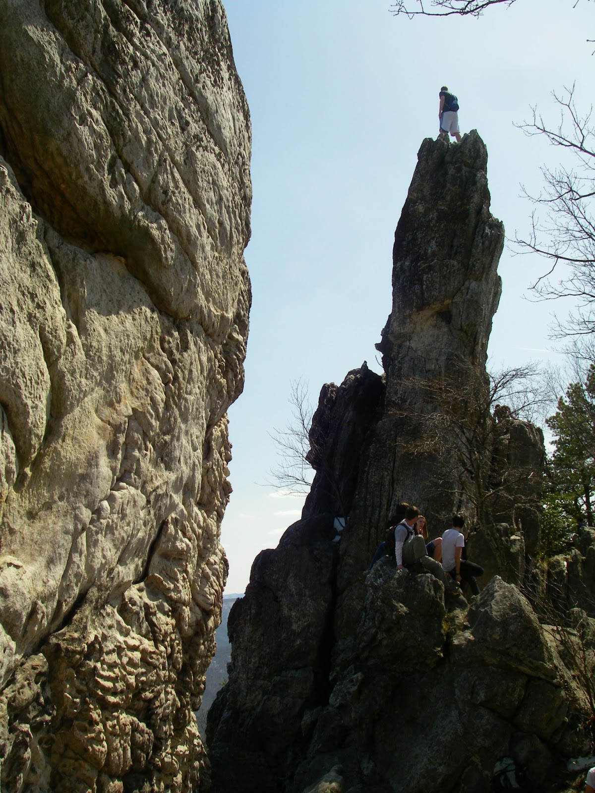
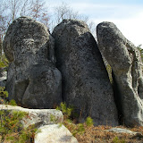
Following the short path from the base of the tower to the edge of the rocks, we turned right and downhill along their eastern edge, following the obvious route into their depths. While there are other similar outcrops spread over a larger area up here, this best, most interesting section covers probably little more than a half acre. The first corridor opens into a 50 yard long passage between forty foot high walls that vary from maybe 6-12 feet wide. But they aren’t necessarily straight up and down. In places, they curve and interlock one way or another, at times blocking the sky from view, and obviously are part of the same rock that long ago split in half and separated. Moving down the corridor, there are intersecting passages laid out like intersecting narrow alleys between buildings. Some are only a foot or two wide, and a few are too small for a person to enter, but most are of an easy size to walk through. Nearing the perimeters, the blocks become lower, and the passages lead back out into the forest, but there are enough passages to explore to occupy an hour, especially on a first visit. They may even seem a bit confusing at first, but it doesn’t take long to figure out where to go and how to get back. And it doesn’t take long after the visit to want to come back again to this enchanting maze in the sky.

The base of the tower gives some idea of how the nearby Great Channels look from above, except they are much deeper.

Despite the limited area the cover, the Great Channels have a slot-canyonesque feel to them.

The crevice is about 30'-40' deep.

Route to Middle Knob from Hayters Gap. To see a larger map click here.

Hike Stats: 6.5 miles out-and-back, 1,200' elevation gain

Pictures from this hike

Pictures from other hikes to Middle Knob and the Great Channels
August 2012
October 2011
July 2011
April 2011
November 2010
May 2009
July 2008
May 2008


Resources:
gpx files and topo maps
Virginia DCR page for The Channels Natural Area Preserve
Channels State Forest brochure and trail map (opens as pdf)
Virginia Dept. of Forestry page for Channels State Forest
TEHCC page for The Channels Natural Area Preserve
EveryTrail.com Guide to The Brumley Mountain Trail
Tri-Cities.com article about Brumley Mountain Trail


View Larger Map
Hayters Gap trailhead coordinates:
36.86468,-81.94699

Google Map for trailhead

Scan QR code to navigate to trailheads with Google Maps on your smartphone


Saturday, March 30, 2013

Dragons Tooth - The Fang of the AT


I may have walked along the dragon's back a few weeks ago, but more recently +Leanne and I climbed up to its tooth, or perhaps more accurately, its fang. This impressive little spire of upright sandstone atop Cove Mountain (actually a fin, not a spire - more on that later) is one of the so-called “Triple Crown” along this section of the Virginia Appalachian Trail. The other two are nearby McAfee Knob and Tinker Cliffs, and all three are spectacular destinations.

Cove Mountain summit and Dragons Tooth from Point 2363
The Dragons Tooth is probably the funnest and most challenging hike of the three, even though by our route it is the shortest. It ain’t Linville Gorge or Old Rag, but the 2 ½ miles to the top have some of the steepest, most scrambly terrain still traversed by the Virginia portion of the famous Georgia to Maine trail. That last sentence is a bit of a sore spot with me, because as time goes by, the Appalachian Trail gets rerouted. Sometimes this is for the better, as it has gotten the trail off of roads and into more scenic and less developed areas. But at other times, it seems the goal is to make the trail as easy as possible, and eliminate every steep bit possible, even if it means bypassing significant summits and worthwhile viewpoints. I’ve had a couple of rants about that in the past and may write a post about it here sometime. But for the time being, I think this section of the A.T. is relatively secure. At least I’m not aware of any intentions to tame it. Hopefully there never are.

This translates to "Fun Ahead!"
 Even without a view or a summit, a steep scramble is always fun and entertaining, and worth doing for its own sake. But here, on the climb up to the top of Cove Mountain, you are treated to all three. Nothing scary or difficult, at least not to most people - but hands may be needed for balance here and there, or to help get up a spot or two with a big step or a little exposure.

We started at the big parking lot for the Dragons Tooth trail on Route 311, rather than where the A.T. actually starts up the mountain on Route 624. There were already a lot of people here, but nothing like there would be later. On the way back down, we were rarely out of sight of at least one more group of people, and even had to wait our turn at a couple more restricted spots. The scene at the trailhead was then reminiscent of a popular Adirondack or White Mountains trailhead. The parking lot was full and there were cars parked up and down the shoulder of the road for a respectable distance. However, we didn’t see many people at first. Most who start here seem to go up the Dragons Tooth Trail, but we took the Scout Trail to the A.T. Not too far beyond this junction, the trail gains the crest of a ridge that leads to Lost Spectacles Gap. But before following it, we first made a short off-trail excursion to nearby Point 2363.
 

Perhaps my favorite part of this hike.
 This little unnamed, unranked summit has a rocky top with great views, and no people even though the trail comes within 250 yards. Indeed, even though I had seen it from higher above on the mountain every time I’d hiked to the Tooth, I had never been to this little crag until two years ago, when Leanne and I made the small extra effort to do so. As bushwhacks go, it’s pretty easy, with only a few briers, and a couple of easy scrambles between the trail and the top. There’s actually even a bit of a faint path part of the way. The views from the top are pretty much 360°, and surprisingly good for being only a few hundred feet above the valley floor, looking down the length of Catawba Valley and up to the Dragons Tooth atop Cove Mountain.

Back on the trail, it quickly gets more interesting as the trail steepens and moves onto a narrow rocky spine known as Rawies Rest. There are a couple of spots where a handhold is needed, at least for balance, and there are more views - though none as wide as from Point 2363. After crossing another minor summit, the trail drops off about 100 feet to Lost Spectacles Gap and the junction with the Dragons Tooth Trail’s upper end. This was one of the first really nice days of Spring, and here is where we joined the steady progression of people headed up to the same place. The trail stays mellow just a bit longer and passes the spot where the trail once headed straight up a spur ridge to the top of the mountain. I followed this route a couple years ago, and while I enjoyed its steepness, I must admit that its lack of views and scrambling makes this one of those cases where the new trail is vastly superior.
 

Typical terrain on the upper part of the trail.
 Beyond here the trail just gets better and better, steepening up and spending more and more time on rock. One of the neatest spots is a nearly vertical section of narrow, stair-stepping ledges that gains about 20 feet and offers a great view from the top. This is possibly my favorite part of the hike - it’s just exposed enough to feel a little risky, but is fun and easy. There are a few more steep sections and even a couple iron rungs placed in the rock to make it easier - though they aren’t really necessary. The trail eventually passes beneath the east side of the outcrop that forms Dragons Tooth, climbs a little more, and the fun ends, well almost. Just ahead, it tops out on the summit of 3,050’ Cove Mountain, where there is a great view east, even in spite of a little warm weather haze.

But the highlight of the hike, and its namesake, is a short distance down a sidetrail off the summit and the AT. Here, right on the very crest of the ridgeline, are a series of Silurian sandstone fins standing tilted upright at a nearly vertical orientation. They are at most ten feet thick near their tops, and the tallest of them - perhaps 50 feet high on the side you first see - is the Dragons Tooth. It drops off even more to the steep slopes below the east side, and at first it appears that the only way to get to the top is by rock climbing. It is somewhat of an illusion though, because the fin slopes down to the south. By walking around the right side, there is an easy way up to a notch in the fin and a crevice that leads back toward the top. You can either go under a chockstone wedged in this slot, then up, or stem up just before it. There is ample room and “safe” seating just above the chockstone for a great lunch and rest spot, and to take in the great 270° view that includes McAfee Knob and Tinker Cliffs - the other two-thirds of the Triple Crown. The Peaks of Otter are also visible 30 miles away and just to the right of McAfee Knob. Getting to the very top of the tooth is a different  matter. It’s only another 30’ or so away, but it gets intimidating quickly. The crest of the fin slopes upward somewhat steeply and narrows down to 4’ wide or less, and it overhangs on the west side. Few people have enough nerve to walk right up to the top. I usually sit about halfway up, and scoot the rest of the way while keeping secure handholds. I don’t go to the very top every time, and I’ve only been brave enough, (or stupid enough) to stand upright on the top once or twice and can’t say I recommend it to anyone - unless they are letting me take their picture, of course. You can probably only stand on the sharp end of a tooth so many times before it bites you. Not feeling overly brave (or stupid), I didn’t stand up today. Actually, I didn’t even go the the very tiptop, opting instead to stand and sit for a while on a narrow ledge on the east face. But there was another guy who climbed up after I had departed, who stood on top as nonchalantly as if he were standing on the ground. It made a great photo op and nobody got bit.
 

Another upright fin adjacent to Dragons Tooth.
The view of Catawba Valley with Tinker Cliffs (center) and McAfee Knob (right) above it.

Below Dragons Tooth, on the AT.
More fun trail.
Yes, this is the trail, my favorite part.


To view a larger map click here.


Hike Stats: 5.3 mile lollipop loop, 1,675' cumulative elevation gain

Pictures from this hike 

Pictures from other hikes to Dragons Tooth
April 2012
February 2011
May 2010
November 2009
April 2009
November 2008
November 2007
July 2007

Resources
gpx files and maps
Hiking Upward page 
USFS page for Dragons Tooth Trail
USFS page for Boy Scout Trail


View Larger Map
Dragons Tooth trailhead coordinates:

37.3789,-80.15606

Google map for trailhead


Scan QR code to navigate to trailheads with Google Maps on your smartphone


Saturday, January 5, 2013

Garden of the Gods, Virginia Style

"Hawk Rock"
Feeling a little cash poor after a week in New York, staying close to home for my outings for a while seemed in order. On January 1, +Leanne  and I upheld a little tradition we have that assumes that whatever you find yourself doing on the first day of the year, you will be doing all year long. So we did a short loop in the Crystal Springs Watershed, on some newly constructed trails we had only recently found out about. This is an area owned by the Town of Wytheville, and is contiguous with the 7,500 acre Big Survey Wildlife Management Area, an area I have spent much time in over the years and the location of one of my dearest places. More on that in a future post. To make a short story even shorter, the loop wasn’t anything particularly exciting, but it was new, and it wound around through pleasant, open woods in a small karst area. You can make things mean whatever you like, but what I took from this is that I would be hiking all year long and still finding new places to explore close to home. I chose to ignore any possible implications that I wouldn’t do anything exciting all year, or that I would be stuck close to home all year. I also had mixed feelings about the fact that I had worked most of the day before hiking...

Not being any richer the following weekend, and feeling unmotivated for a big day or a long drive anyway, I decided I would go up on the Big Survey and check out a couple areas off-trail that I had reason to believe I might find some new views from. This would allow me to claim another ascent of Peak 3460, just so I could get in a peak for the day. It would also take me through the “Garden of the Gods”, a neat little area of Lick Mountain where there are a number of large rock outcrops strewn along a powerline swath and throughout the adjacent woods. Several of these have rather unusual forms and I have given them my own names, completely unofficial, but descriptive and appropriate nevertheless. Not to be confused with other better known, more spectacular, and larger areas having the same name, including ones in Colorado, Utah, Illinois, and Hawaii, this “Garden of the Gods”, as far as I know, is also completely unofficial in its naming. It’s definitely not on the map, and though I had been there quite a few times over the years, I had never heard it called that before I stumbled across the name online a few years ago. That is still the only place I personally have seen it named that - in a newsletter published by the Virginia Herpetological Society. It was one of several sites on the Big Survey where they went for a field trip to study the native reptiles and amphibians, and they described it as “a ridge of large limestone outcrops and boulders bisected by a powerline right-of-way”. Actually, I think the rocks are a mixture of sandstone and quartzite, but I’m no geologist. Regardless, I’ve done enough caving that I’m fairly confident there is no limestone on this ridge.

The "Moai". Leanne scrambled atop for scale.
An easy two miles or so, including taking a couple dozen steps off-trail to bag Peak 3460 along the way, and I was in the Garden. Most of the interesting rocks are spread along and around a 3/10 long section of powerline swath from a small stream to the crest of Lick Mountain. Other people may see different things, but to me, two of the most interesting rocks are the ones I call “The Moai” and “Hawk Rock”. The former is a towering formation with a head and face on top that probably looks more like a “Rock’em Sock’em Robot” than anything, but has always made me think of the enigmatic statues on Easter Island. The latter is a 10’-12’ tall hawk perched on the ground and looking back over its shoulder. Then there is the spotted boulder of “Dalmation Rock” and the free-standing pillar that I can’t decide if I prefer to call “The Monolith” or “The Megalith”. One of the first formations you come upon is an assembly of three large upright rocks standing closely side by side. I like “The Three Gossips” as a name, based on a formation of that same name in Arches National Park, but these three rocks, on a smaller scale, probably look vaguely more like another formation there known as “Three Penguins”. Farther in the woods is “Big Rock”. It doesn’t really look like anything, but it is big, and it has a series of crevices underneath it. You can also, with caution, climb to the top of it for some limited views. Farther away still, in a disconnected area near the possible viewpoints I came here to explore, is another scattering of outcrops on the south side of the mountain. The most interesting formation here is the “Bunny Ears”, two upright pinnacles positioned side by side. Closer looking might reveal yet more rocks suggestive of a name.

"The Three Gossips"
There are some limited views north from the crest of the mountain where the powerline crosses it, but on this particular hike I wanted to explore a couple of areas farther east along the crest which I had studied on Google Earth, as well as the cluster of outcrops where “Bunny Ears” is located. The latter spot I had been to once before, and I had also explored the crest from Lots Gap west to the tiny closed contour just east of Point 3439, but not the 8/10 mile between there and here. I simply followed the top of the ridgeline as closely as possible, though there were some detours for blowdowns and briars which were quite thick in spots. I ended up finding a couple of decent views from outcrops, one to the north a short distance before Point 3439, and another to the south from the small contour east of Point 3439. They were worth getting to once, but probably not a second time.
 

Overlooking Wytheville from near Point 3439
"Bunny Ears"

Upon leaving the second view, I dropped down to the south into the other area of outcrops and got a pretty good angle on the “Bunny Ears” then made my way back to the powerline. From here I bushwhacked up to another outcrop about 100’ below the crest of the mountain and 4/10 mile east of Peak 3460. This one had some pretty good views of where I had just been, as well as a wider view to the north and northeast. Not really any good places to sit, but maybe worth an occasional return visit since it’s only about 100 yards off of the trail which I then climbed up to for the final leg of the hike. All in all, a well spent few hours close to home with something old and something new.

*Note - As of January 1, 2012 the Virginia Department of Game and Inland Fisheries requires a permit for all recreational use on state owned wildlife management areas, of which Big Survey is one. You are already covered if you possess a valid state hunting or fishing license. Otherwise you must purchase either a day ($4) or an annual ($23) access permit. You may buy these from any license agent or online from their website here.

Point 3439 and the powerline area where the "Garden of the Gods" is located. Most of the formations are out of sight under the powerline, but the outcrop directly behind it on the right is "Big Rock" and the highest rock above that is the "Bunny Ears".


The route of this hike with side trips. To view a larger map click here.


Hike Stats:
5.5 miles
1,100' cumulative elevation gain

Garden of the Gods only (out and back)
4.25 miles
860' cumulative elevation gain

Garden of the Gods, VA
Pictures from this hike

Pictures from other hikes to the Garden of the Gods
March 2012
March 2009 
There are also two scanned pics from prior to 2007 in this album

Resources and contacts:
Virginia DGIF
gpx and kml files, topo maps


Trailhead coordinates: 36.90369,-81.03585


Google map for trailhead

Scan QR code to navigate to trailheads with Google Maps on your smartphone: