 |
| Charlie Zerphey and Tom Layton making their way up one of the magnificent open ridges of Beartown Mountain. Middle Knob, home of the Great Channels of Virginia, is the next high peak in the distance. |
Beartown
Mountain is one of my favorites. At 4,689' above sea level, it is the seventh highest peak in Virginia and is comprised of a rather large plateau surrounded by steep slopes on every side that drop 2,000 feet into the valleys below. It has an impressive form and the top is one of the few places in the state that harbors a boreal forest of red spruce. It also has a reputation for being one of the tougher hikes in
Virginia, and, arguably, in the East. That status is probably well deserved if you stay on state
lands and approach it from the east from within the Clinch Mountain
Wildlife Management Area. It will likely be a minimum hike of 8 miles
with a 2,200’ elevation gain, but that’s not the problem. The difficulty
is that the large summit plateau is technically trail-less and covered
with a dense jungle of tangled rhododendron and thick spruce interspersed with many blowdowns. Throw in some briars for good measure and just accept the fact that you probably don't want to try this in the Summer unless you're not too bright.
There is,
however, a faint and intermittent path that more or less follows the
boundary line of the state land. If you can keep track of this path, you
can move. If you step off of it you will be fighting for every step in
many areas, prying back rhododendron branches to take a step. There may be crawling too. Or you may not be able to move at all. There will
likely be much colorful language, probably some blood loss, and perhaps some whimpering. It is bad enough that I never made it
to the top the first two times I tried it many years ago. The three companions I was hiking with this time never made it on their first attempt either, hitting a wall of impenetrable rhododendron near the north edge of the plateau.
 | ||
| A case of being worse than it looks, this is some of the typical vegetation obstacles on the Beartown summit plateau. |
That said, it is nevertheless possible to have a grand adventure by doing it the hard way. On my second successful hike to the top, in November 2009, accompanied by my good friends Shane Ashby and his dad Dane, we hiked up Dry Branch on a steep trail to the open crest of Rich Mountain, then headed off-trail up the rocky buttress that gains the south end of the plateau. We found the path then soon lost it. After considerable thrashing about without covering much ground, and some backtracking, we found it again and vowed not to lose it. It was still slow going, but we eventually made it to the top and continued northeast to Mutters Gap, managing to stay on what became, at times, a pretty good trail. We were in the midst of trying to be the first to visit all of Virginia's 4,000' peaks so we were also able to bag unnamed Peak 4,300 just east of the gap. We continued down Red Creek, at first on an old trail. But this eventually fizzled out and we found ourselves in a rather long stretch of forest that had suffered major damage from a windstorm. As a result, there were innumerable blowdowns to fight our way through and it was once again slow going. If I remember correctly, that hike ended up being around 17-18 miles and took all of the daylight hours but felt strangely rewarding afterwards, enough so that I would consider doing it again sometime. But I would probably skip Peak 4,300 and spend more time exploring the rock outcrops on the high eastern spur of Beartown.
But if you're lucky, knock on the right door, and ask very politely, there are a number of other possible approaches from private property that are not only shorter, but also allow doing at least part of the hike in open meadows. There is, however, no avoiding the rhododendron and spruce on top - only shortening the distance you must find your way through it. I've only explored two of these and I'm not at liberty to put that information on a public blog, nor have I been told by any landowners that they would allow other people to do so, especially if it became a habit or they started experiencing crowds. But I know a tiny handful of other people have been able to go up other routes as well, so anything is possible with some on the ground investigating and a courteous approach. Private property is a frequently encountered issue with Eastern peakbagging on obscure peaks but there are so few peakbaggers in the Southeast that many landowners are curious as to why you would want to go up there, while others may find it novel that you are interested in climbing their mountain.
With this in mind, I was lucky enough to get permission to try a potentially easier and more scenic route up Beartown with three peakbagging friends who had failed to reach the top this past Spring. John Hamann had flown in from New Mexico to give this one another try, while +Tom Layton drove up from Boone, NC and Charlie Zerphey came down from Pennsylvania. All three wanted to summit Beartown for different reasons. John likes to climb peaks that have a combination of at least 25 miles of isolation from the nearest higher peak as well as at least 1,000' of prominence, basically the most dominant peak in a particular region. Charlie is only interested in county highpoints, having completed ALL of the highpoints in ALL of the states north and east of Virginia. Beartown was the only county he lacked to complete Virginia. His completion map, as of this writing not updated to show Virginia completed, is online here. Tom is more of a generalist, like me, and works on many lists at once. He wanted Beartown for its COHP status, but also because it would complete all 13 Virginia peaks above 4,500' for him. I just wanted to do it for a fourth time and by a new route.
We couldn't have asked for a better day! Two weeks after Hurricane Sandy came through and dumped up to three feet of snow in the Southern Appalachians, a return to mild weather afterward had already melted virtually all of it. Only a few drifts could be seen on the high ridges above and under blue skies and sun it warmed up to an unseasonably warm 65° even up at 4,500'! We were able to hike comfortably in shorts and t-shirts even though it was November 11.
Though I would have preferred to stay on the open ridges both ways, the owner suggested an easier route up that climbed a drainage in the woods and we decided to try it. I think we misunderstood his directions because the woods road we followed eventually fizzled out and we had to bushwhack the rest of the way to the ridgeline. It was steep but otherwise easy because the woods were open with little brush. Once on the crest of the ridge, it was nothing but grassy meadows with wonderful views around the entire horizon excepting where Beartown itself loomed steeply above us. The ridge we were on continued up rather steeply itself until abruptly easing off a few hundred feet below the summit, at which point we re-entered the woods and began the final ascent to the plateau. We encountered some bluffs and low cliffs as the steepness resumed and then we got into a bit of snow and the infamous rhododendron thickets of the mountain. But our route was a success as it led up through the at least negotiable tangles and sidehilled up a ramp along the base of some 20' high cliffs. Then, just like that, we were on the edge of the plateau and only a quarter mile away from the summit. We thrashed around a few minutes in the chaos of rhododendron and spruce blowdowns, then found the path I knew was there and "strolled" the last few minutes to the cairn on the summit. This particular spot is more open and quite pleasant, very much like the spruce-clad summit of Mount Rogers and is one of the reasons I like it.
Charlie and Tom both finished a list as they touched the summit, with Charlie completing the highpoints of all 134 Virginia counties, something that took him several years to do and is even more impressive when you consider that some counties, especially the eastern ones, have multiple contenders for the highest point. Charles City County, for example, has 70 spots, any one of which may be the true highpoint. Charlie had to visit them all. Fortunately, Russell County has one clear cut highpoint, as do most of the other mountainous counties in the state. This was Charlie's 13th state completion! And at 4,689', Beartown was the last of Virginia's peaks above 4,500' that Tom had not been on, a noteworthy achievement in its own right.
After a few congratulatory moments and some picture taking, we moved on a few hundred more feet to a hidden overlook I knew about to eat lunch and enjoy the great views to the west while looking down on our return route. The rest was cake and I already have a great idea for my next hike here. It will probably involve some colorful language, blood loss, and whimpering.
Though I would have preferred to stay on the open ridges both ways, the owner suggested an easier route up that climbed a drainage in the woods and we decided to try it. I think we misunderstood his directions because the woods road we followed eventually fizzled out and we had to bushwhack the rest of the way to the ridgeline. It was steep but otherwise easy because the woods were open with little brush. Once on the crest of the ridge, it was nothing but grassy meadows with wonderful views around the entire horizon excepting where Beartown itself loomed steeply above us. The ridge we were on continued up rather steeply itself until abruptly easing off a few hundred feet below the summit, at which point we re-entered the woods and began the final ascent to the plateau. We encountered some bluffs and low cliffs as the steepness resumed and then we got into a bit of snow and the infamous rhododendron thickets of the mountain. But our route was a success as it led up through the at least negotiable tangles and sidehilled up a ramp along the base of some 20' high cliffs. Then, just like that, we were on the edge of the plateau and only a quarter mile away from the summit. We thrashed around a few minutes in the chaos of rhododendron and spruce blowdowns, then found the path I knew was there and "strolled" the last few minutes to the cairn on the summit. This particular spot is more open and quite pleasant, very much like the spruce-clad summit of Mount Rogers and is one of the reasons I like it.
 | ||||||||||||||||||||
| Above: Myself, John Hamann, Tom Layton, and Charlie Zerphey on the summit of Beartown Mountain. |
 |
| Charlie Zerphey completed his goal of visiting the highpoints of all 134 Virginia counties when he reached the 4,689' apex of Russell County on November 11, 2012. He is only the second person to have ever done so, the first being Don Desrosiers who, coincidentally, finished on the same summit on July 1, 2005. |
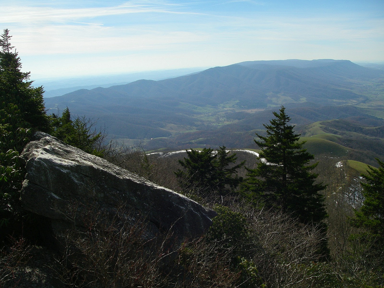 |
| The view west toward Middle Knob and Brumley Rim from near the summit of Beartown. |
More pictures from this hike
Pictures from other hikes to Beartown Mountain:
July 2011
November 2009
May 2008
Resources and Contacts:
Clinch Mountain WMA Info
Clinch Mountain WMA Map
gpx file and topo maps
Pictures from other hikes to Beartown Mountain:
July 2011
November 2009
May 2008
Resources and Contacts:
Clinch Mountain WMA Info
Clinch Mountain WMA Map
gpx file and topo maps
Hello Mr Shortt, wanted to let you know my wife and I just finished the Beartown hike up from the Clinch WMA Muck road. It was every bit as horrible as you described. We followed your gps tracks where we could and it wouldn't have been possible without them. Thanks!
ReplyDeleteAwesome! I'm glad you found out helpful. Hope you had good views from Rich Mountain and found the view near the summit as well.
DeleteWe are going to try to reach the summit at Beartown this week-end via Muck Road.
ReplyDeleteIt was years ago when we hiked to the summit from the other side.
Any suggestions from the Muck Road side? We have explored the area a couple times trying to decide the best route to take. We have encountered lots of snow, high water and fog. That seems to have changed now since we have experienced a dry spell.
Yesterday, the creeks were low and one was completely
dry.
It's not too bad if you have a GPS and/or topo map, you can see the best route to take to make it to the top of the plateau. Once you're up there you have a VERY long and arduous hike across the top, it will take forever. Stay close to the cliff edge on your left where it's rocky (and therefore less vegetation). Good luck!
Delete