 |
| Upper Plotter Kill Falls |
It was nearly dusk when my buddy +Peter Barr and I made it to the Indian Ladder trailhead in John Boyd Thatcher State Park on that trip. We had just enough time to get to the base of the spectacular 116' plunge of Mine Lot Falls while there was still enough light to see it and take a few pictures. Then we drove up the nearby high point of the eastern escarpment in the dark, mainly just to say we had been there.
That was enough of a taste to convince me that some of the other nearby places I had read about would also likely be worth getting to sometime. As luck would have it, that sometime was now, less than three months later. Leanne wanted to visit two of her cousins living near Albany. I would only have a few hours to spare, but that would be better than nothing.
 |
| The trail atop Vromans Nose hugs the edge of the cliffs. |
 |
| Overlooking the Schoharie Valley. |
 |
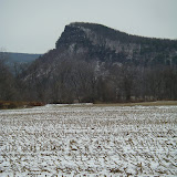
| Vromans Nose |
I started at the upper trailhead, above the larger falls and followed the icy trail downhill and across the creek to the top of the Upper Plotter Kill Falls. They were quite impressive and mostly frozen - though I was a little skeptical that they were 60’ high as claimed in the guidebook. I would have guessed 40, maybe 50 feet. Regardless of their height, they presented a scene of great beauty as the stream poured over the brink and poured into the rock walled amphitheater below. I continued down the trail along the rim until I was able to catch a glimpse of the 40’ high Lower Plotter Kill Falls and Rynex Creek Falls as well. I considered trying to descend the narrow, very steep ridge between these two falls to get a better view from below but decided against it when I found it to be quite icy and having some dropoffs lower down. I settled for backtracking a short distance and taking the trail down to the creek between the upper and lower falls. From here it was easy to continue upstream to the base of the upper falls for a better view. From this vantage it was easier to see the entire cataract and the masses of ice it had built up. The spray had also encased the trees immediately downstream, its weight bending their branches over the frozen stream like bowers. It was a scene of great beauty, mostly in black and white, that I left behind as I made my way back up the trail wishing I had time to explore a little while longer.
The route of the Vromans Nose hike. To see a larger map click here.
The route of the Plotter Kill Falls hike. To see a larger map click here.
Hike Stats:
Vromans Nose - 1.5 miles, 500' elevation gain
Plotter Kill Falls - 1.4 miles, 150' cumulative elevation gain
 |
| Vromans Nose & Plotter Kill Falls, NY |
More pictures from these hikes
Resources:
Local Hikes - Vromans Nose
Local Hikes - Plotter Kill Preserve
Hiking The Plotter Kill Preserve
Vromans Nose (gpx, kml, topos)
Plotter Kill Falls (gpx, kml, topos)
Trailhead Coordinates
Vromans Nose: 42.59474,-74.3584
Google Map for trailhead
Scan QR code to navigate to trailheads with Google Maps on your smartphone:

Plotter Kill Falls: 42.82567,-74.05187
Google map for trailhead
Scan QR code to navigate to trailheads with Google Maps on your smartphone:

It seems that you really had a great escapade. And those places were really breathtakingly beautiful. Thanks a lot for sharing this one.
ReplyDeleteTheIPSStore.com
You're welcome! Yeah, it was a good trip. Can't wait to get back to New York again.
ReplyDelete