Saturday, January 5, 2013

Garden of the Gods, Virginia Style

"Hawk Rock"
Feeling a little cash poor after a week in New York, staying close to home for my outings for a while seemed in order. On January 1, +Leanne  and I upheld a little tradition we have that assumes that whatever you find yourself doing on the first day of the year, you will be doing all year long. So we did a short loop in the Crystal Springs Watershed, on some newly constructed trails we had only recently found out about. This is an area owned by the Town of Wytheville, and is contiguous with the 7,500 acre Big Survey Wildlife Management Area, an area I have spent much time in over the years and the location of one of my dearest places. More on that in a future post. To make a short story even shorter, the loop wasn’t anything particularly exciting, but it was new, and it wound around through pleasant, open woods in a small karst area. You can make things mean whatever you like, but what I took from this is that I would be hiking all year long and still finding new places to explore close to home. I chose to ignore any possible implications that I wouldn’t do anything exciting all year, or that I would be stuck close to home all year. I also had mixed feelings about the fact that I had worked most of the day before hiking...

Not being any richer the following weekend, and feeling unmotivated for a big day or a long drive anyway, I decided I would go up on the Big Survey and check out a couple areas off-trail that I had reason to believe I might find some new views from. This would allow me to claim another ascent of Peak 3460, just so I could get in a peak for the day. It would also take me through the “Garden of the Gods”, a neat little area of Lick Mountain where there are a number of large rock outcrops strewn along a powerline swath and throughout the adjacent woods. Several of these have rather unusual forms and I have given them my own names, completely unofficial, but descriptive and appropriate nevertheless. Not to be confused with other better known, more spectacular, and larger areas having the same name, including ones in Colorado, Utah, Illinois, and Hawaii, this “Garden of the Gods”, as far as I know, is also completely unofficial in its naming. It’s definitely not on the map, and though I had been there quite a few times over the years, I had never heard it called that before I stumbled across the name online a few years ago. That is still the only place I personally have seen it named that - in a newsletter published by the Virginia Herpetological Society. It was one of several sites on the Big Survey where they went for a field trip to study the native reptiles and amphibians, and they described it as “a ridge of large limestone outcrops and boulders bisected by a powerline right-of-way”. Actually, I think the rocks are a mixture of sandstone and quartzite, but I’m no geologist. Regardless, I’ve done enough caving that I’m fairly confident there is no limestone on this ridge.

The "Moai". Leanne scrambled atop for scale.
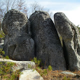
An easy two miles or so, including taking a couple dozen steps off-trail to bag Peak 3460 along the way, and I was in the Garden. Most of the interesting rocks are spread along and around a 3/10 long section of powerline swath from a small stream to the crest of Lick Mountain. Other people may see different things, but to me, two of the most interesting rocks are the ones I call “The Moai” and “Hawk Rock”. The former is a towering formation with a head and face on top that probably looks more like a “Rock’em Sock’em Robot” than anything, but has always made me think of the enigmatic statues on Easter Island. The latter is a 10’-12’ tall hawk perched on the ground and looking back over its shoulder. Then there is the spotted boulder of “Dalmation Rock” and the free-standing pillar that I can’t decide if I prefer to call “The Monolith” or “The Megalith”. One of the first formations you come upon is an assembly of three large upright rocks standing closely side by side. I like “The Three Gossips” as a name, based on a formation of that same name in Arches National Park, but these three rocks, on a smaller scale, probably look vaguely more like another formation there known as “Three Penguins”. Farther in the woods is “Big Rock”. It doesn’t really look like anything, but it is big, and it has a series of crevices underneath it. You can also, with caution, climb to the top of it for some limited views. Farther away still, in a disconnected area near the possible viewpoints I came here to explore, is another scattering of outcrops on the south side of the mountain. The most interesting formation here is the “Bunny Ears”, two upright pinnacles positioned side by side. Closer looking might reveal yet more rocks suggestive of a name.

"The Three Gossips"
There are some limited views north from the crest of the mountain where the powerline crosses it, but on this particular hike I wanted to explore a couple of areas farther east along the crest which I had studied on Google Earth, as well as the cluster of outcrops where “Bunny Ears” is located. The latter spot I had been to once before, and I had also explored the crest from Lots Gap west to the tiny closed contour just east of Point 3439, but not the 8/10 mile between there and here. I simply followed the top of the ridgeline as closely as possible, though there were some detours for blowdowns and briars which were quite thick in spots. I ended up finding a couple of decent views from outcrops, one to the north a short distance before Point 3439, and another to the south from the small contour east of Point 3439. They were worth getting to once, but probably not a second time.
 

Overlooking Wytheville from near Point 3439
"Bunny Ears"

Upon leaving the second view, I dropped down to the south into the other area of outcrops and got a pretty good angle on the “Bunny Ears” then made my way back to the powerline. From here I bushwhacked up to another outcrop about 100’ below the crest of the mountain and 4/10 mile east of Peak 3460. This one had some pretty good views of where I had just been, as well as a wider view to the north and northeast. Not really any good places to sit, but maybe worth an occasional return visit since it’s only about 100 yards off of the trail which I then climbed up to for the final leg of the hike. All in all, a well spent few hours close to home with something old and something new.

*Note - As of January 1, 2012 the Virginia Department of Game and Inland Fisheries requires a permit for all recreational use on state owned wildlife management areas, of which Big Survey is one. You are already covered if you possess a valid state hunting or fishing license. Otherwise you must purchase either a day ($4) or an annual ($23) access permit. You may buy these from any license agent or online from their website here.

Point 3439 and the powerline area where the "Garden of the Gods" is located. Most of the formations are out of sight under the powerline, but the outcrop directly behind it on the right is "Big Rock" and the highest rock above that is the "Bunny Ears".


The route of this hike with side trips. To view a larger map click here.


Hike Stats:
5.5 miles
1,100' cumulative elevation gain

Garden of the Gods only (out and back)
4.25 miles
860' cumulative elevation gain

Garden of the Gods, VA
Pictures from this hike

Pictures from other hikes to the Garden of the Gods
March 2012
March 2009 
There are also two scanned pics from prior to 2007 in this album

Resources and contacts:
Virginia DGIF
gpx and kml files, topo maps


Trailhead coordinates: 36.90369,-81.03585


Google map for trailhead

Scan QR code to navigate to trailheads with Google Maps on your smartphone:


1 comment:

  1. Great photos and good information. Thank you for sharing.

    ReplyDelete