Sunday, December 1, 2013

Comers Rock - Earning Your Views


There are often days when I am not especially motivated to go hiking, but feel like I should get out in the woods for a few hours anyway. These same days, I usually don't want to be gone all day, nor do I want to drive very far - generally no farther than thirty minutes away. While I’m lucky enough that there are a few very nice destinations that close to home, that distance nevertheless really limits the choices, and while a lot of the hikes that close are pleasant enough, most are little more than a walk in the woods. There just aren't very many spectacular destinations really close by. Some may be nice enough otherwise, but lack appeal because there is also a road to or near the final destination. That usually takes away any feeling of remoteness out wildness, and usually makes one question why they are hiking up, when they may well encounter hordes of people who drove up. And while I myself am not averse to driving up certain peaks on occasion, it’s rarely as rewarding as a good hike to the same place.

Such is the case with Comers Rock. One can drive to within a hundred yards or so of the top, a fact that often makes me discount it as a "serious" hiking goal. But I always forget just how good views actually are from up there on a clear day, and they are even better when you earn them by hiking up. And despite the proximity of a road, there are no"hordes". Besides, it's a pleasant hike anyway, if the chosen route is through the Little Dry Run Wilderness located to the north of the mountain. For the best part of the first three miles, this trail follows the namesake creek of the Wilderness (a rather grandiose term for this little 2,858 acre parcel), a tiny little stream with gorgeous hemlock lined banks, and small pools and undercut banks that harbor native brook trout, some of the prettiest freshwater fish there are. Finding their haunts was one of the original motivations for my interest in hiking. Though I don't fish for brookies any more, I still love visiting the beautiful places they live.


Tommy Bell along Little Dry Run. While not from this particular hike, it shows how pretty the area is.
The hike starts with an unbridged crossing of Dry Run. If the creek is low enough to rockhop here, then the rest of the hike is probably not an issue. If it’s really high, you might want to come back another day. The trail follows Dry Run upstream a very short distance, then sidehills back to the North and West to reach Little Dry Run. It crosses this smaller stream numerous times, and is a bit vague in a few spots, but as long as the creek is near, so is the trail until one reaches the uppermost headwaters - and if one avoids the trailless northern tributary at the 1.4 mile mark. On another note, it was near this spot a few years ago that I turned off the trail to climb Peak 3,300, the last summit I needed to have climbed all of Wythe County's 43 ranked peaks. That adds another element to my fondness of this area. As the stream dwindles to a trickle, the trail steepens and climbs to a broad saddle to intersect the Virginia Highlands Trail. This makes an appealing return route by following it back to the highway, but the way to the top avoids it and continues straight across, onward and upward from this divide that separates Little Dry Run from Jones Creek. While it is never really steep, the remaining mile-and-a-half is decidedly uphill. Very close to the end, after all one’s work to get here, the trail disappointingly deposits one onto the gravel Forest Service road going to the same place. However, after only a hundred yards, it ends and a set of rustic stone stairs lead the remaining steps.  At least the final 150 yards is foot travel only, so there is some solace in knowing that even if you share the summit with other people, you don’t have to share it with their vehicles as well. And you know they didn’t see the pretty places you were privileged to see on the way up. As it turned out on this visit, I had the top all to myself the whole time I was here.

Brumley Mountain, Middle Knob, and Beartown on the horizon.
The summit has a couple of attributes of interest to only to peakbaggers. At 4,100’ in elevation, it is one of Virginia’s 97 ranked Four-Thousand Footers, coming in as the 62nd highest peak in the state. As it is the only peak over 4,000’ in Wythe County, is also the county highpoint for my home county. For everyone else, there are the views. The top has a few rock outcroppings, as well as a deteriorating viewing platform. Even though the railings are falling off and trees have been allowed to block the view to the West, this low platform offers quite a dramatic prospect. Starting in the Northwest and turning clockwise all the way back to the Southwest, the phalanx of mountains marching around the horizon includes a distant Brumley Mountain, Middle Knob, mighty Beartown Mountain, and White Rock on the Clinch Mountain massif. Closer in is Glade Mountain and its associated ridges as well as the sixty mile long sweep of Walker Mountain. Beyond it, to the North, are cliffbound Knob Mountain and Wynne Peak, as well as Chestnut Ridge, spruce-clad Balsam Beartown (sixth highest in Virginia, and the highest that isn’t part of the Mount Rogers massif), Garden Mountain, and East River Mountain. Most of Wythe County is in sight, and notable peaks include its most prominent peak of Griffith Knob, pointy Queens Knob, Cove Mountain, and its most isolated peak of Sand Mountain and attendant High Rocks, Lick Mountain, Stuart Mountain, Swecker Mountain, and Henley Mountain. This latter range separates the Cripple Creek and Reed Creek Valleys. Draper Mountain, Peak Knob, and High Knoll are next, while much farther to the Northeast are the high peaks of Sugar Run Mountain and Bald Knob, the latter over 50 miles away and Virginia’s most isolated peak. I can’t honestly say I have ever really looked for it, or if I have even been here on a clear enough day, but some research shows me that it should also be possible, at a bearing of 61°, and about halfway between Peak Knob and High Knoll, to see Apple Orchard Mountain from here as well. This is Virginia’s most prominent peak, and is nearly 110 miles away. If indeed it is ever visible, this would probably be one of the longest line of sight views possible in Virginia, if not the entire Southeast. It was clear on this most recent visit, but definitely not that clear. Much of the Eastern end of the Iron Mountains, of which Comers Rock itself is part of, extend as far as the New River. Things flatten out a bit on the rolling Blue Ridge Plateau to the Southeast, but a couple notable exceptions jutting up are Floyd County’s and Carroll County’s respective highpoints of Buffalo Mountain and Fisher Peak. To the south rise the considerably higher Grayson County peaks of Point Lookout and Buck Mountain, the eleventh and eighth highest mountains in the state. While not exactly in your face, the most dramatic view is probably to the Southwest. This would be the compact cluster of North Carolina mountains known as the Amphibolites. Among the rugged and spectacular peaks in view are Mount Jefferson, Phoenix Mountain, Bluff Mountain, Elk Knob, ragged Three Top Mountain, Snake Mountain, and the aptly named The Peak. Farther away are the glorious balds of the Roan Highlands. Quite an amazing collection of peaks really, but still not quite everything. By moving off the platform and onto the rocks nearby, one can look to the right of nearby Bald Rock Ridge and get a pretty good look at one of my most special places - the Grayson Highlands. Rising above First, Second, and Third Peaks are Virginia’s highest terrain. Big Pinnacle, Wilburn Ridge, and Mount Rogers are all in sight, and beckon as they always do. And by walking up, you earned the views, and can appreciate them even more. If you come in the Winter after a big snow, it might not even be possible for anyone to drive up even if they wanted to.

The eastern Iron Mountains. Floyd County's Buffalo Mountain is faintly visible near the center of the horizon.
The rugged Amphibolites of North Carolina, including Phoenix Mountain, Bluff Mountain, Elk Knob, Three Top, Snake Mountain, and The Peak.
Virginia's highest and most alluring terrain - looking towards Big Pinnacle, Wilburn Ridge, and Mount Rogers.

To see the topo map for this hike larger on this site, click on the image or click here to see it on CalTopo.


Elevation profile for this hike.

Hike stats: 9.9 miles, 2,000 cumulative elevation gain


Pictures from other visits to Comers Rock

Resources:

Trailhead Coordinates:  36.78855, -81.18327 
(trail begins across road from parking area, on West side of road)

Saturday, November 2, 2013

Bluff Mountain And Hellgate Ridge - Neglect and Rediscovery


Sometimes you realize that you shouldn't have waited so long to do a hike again. Such was my case with Bluff Mountain. I had hiked the Appalachian Trail up this mountain once before, way back in 1994. I don't really remember what I thought of it then. Maybe it was hazy, or maybe I just didn't feel like writing, because my journal from that day only makes mention that I was there. But I still knew it had a view and so it seemed like it was time to rediscover it. I've been very close to it again quite a few times during the intervening years, on a number of hikes to Rocky Row, and also to several other nearby peaks like Pinnacle.

It is a very conspicuous peak from a number of more distant viewpoints throughout the region. One reason for that is that despite its modest elevation of only 3,372', it is the most prominent peak along a 26 mile stretch of the Blue Ridge and dead center between the even more prominent, but less distinctive peaks of Apple Orchard Mountain and Rocky Mountain. It is one of only 106 mountains in Virginia to have over 1,000 feet of prominence and rises to a fairly small summit. These qualities make it stand to reason that it was once a firetower peak, and should command an extensive view. It was time to refresh my memory...

My approach the first time had been on the Appalachian Trail, but several explorations of other peaks in this area had brought a potentially interesting, and more challenging option to my attention. Assuming the Forest Service map was correct and there was public access at the start, the topo showed a pipeline and attendant service road going up Bennetts Run, then making a near beeline most of the way for the summit from the northwest. Satellite imagery seemed to confirm the same and so a plan was made. My frequent hiking companion +David was free, and up for a good hike, so off we went to explore.


Looking back at Pinnacle.
We found the gated Forest Service road and began our hike at an elevation of only 900', leaving a respectable climb to the top. The route was a bit confusing at the beginning as we skirted around a large car junkyard on private property, then tried to follow a more obscure woods road to the pipeline. We lost it in brush and briars and had to just cut through the woods to find the pipeline, only to discover it too was pretty brushy, with waist high greenery still not quite knocked down by the return of cold weather. This would not be fun in the green months but nevertheless led us up Bennetts Run, and between the peaks of Pinnacle and Target Hill (both worthy destinations themselves) to the point where the small stream split into its North and South Forks. The hiking became much more interesting at this point, as the pipeline abandoned the overgrown drainage and climbed steeply straight up the fall line of the Northwest Ridge of Bluff Mountain. The route became a rocky treadway, a narrow road really, and climbed up through open woods with some occasional views behind us of Pinnacle and Target Hill, and through the “V” they create, which allowed us to see part of the fog-laden Maury River Valley and the ridges of the Alleghenies beyond. The grade eased briefly in a couple areas, but overall it remained a fine, steep ridge that was relatively narrow and scenic. I liked it a lot!


Rocky Mountain and No Business Mountain.
Finally, at about the 2,500’ level, the pipeline veers abruptly south to drop down a few hundred feet in elevation, then climb again to the shallow gap separating Bluff Mountain and Hellgate Ridge. The ridge we were on looked more appealing than ever now, and we certainly didn’t see any reason to lose elevation, so we opted to head off-trail and continue on our current course to the top, which was now only ¾ of a mile away, albeit still over a 800 feet higher. There was a bit of scrambling, some limited views, and a bit of rhodo-whacking to round things out, but all in all it was a fine little climb. A short distance from the top, we hit the old fire tower access road and followed it the remainder of the way.


The panorama West and North from Bluff Mountain looks across the Great Valley to Big Butt, Jump Mountain, and Great North Mountain in the Alleghenies as well as toward such Blue Ridge summits as Whites Peak and Adams Peak.
Though the lookout tower that would have allowed a 360° panorama is sadly now long gone, the semi-open summit did not disappoint. Between the hardwoods and a curious handful of red spruce - usually found considerably higher or farther North, there was a great view to the south of High Peak and No Business Mountains, with the vast flattening of the Piedmont extending beyond to the limits of the horizon. But the real reward was the sweeping view of mountainous country to the North and Northeast. Close at hand were many of the low, but steep, rugged, and pointy peaks that form the western front of the Central Blue Ridge in Virginia. Among these were Elephant Mountain, Garnet Peak, Silver Peak, Whites Peak, and also Adams Peak and McClung Mountain - the last two personal favorites. To the left of all those peaks was a long swath of the Great Valley, with Buena Vista and Lexington both in sight. Beyond the valley rose the long wall of the Alleghenies, with House Mountain, Big Butt, Jump Mountain, and Elliot Knob all plainly in view along with many others. I have no intention of allowing twenty years to pass again before a third visit.

A neat pinnacle on Hellgate Ridge.
Rather than backtracking on the return hike, we followed the Appalachian Trail south a short distance, then headed off-trail again to traverse Hellgate Ridge. This was rather thick in places, but we did find a neat pinnacle on the ridgeline, as well as a small clifftop overlook with views of Silas Knob and Big Rocky Row. We also found a limited, but great view of conical Peak 2310 and impressive looking Sugarloaf Mountain.

We should have continued along the ridgeline to the top of Pinnacle for more great views and another summit for the day, but instead we dropped back down to Bennetts Run from the low spot on the ridge. This required some very steep and tedious sidehilling, and dealing with a lot of fallen trees near the creek before climbing back uphill again anyway to regain the pipeline trail. From there is was easy walking on now familiar terrain, and we found and successfully followed the faint road we had lost near the beginning of the hike. It will serve me well in the not too distant future when I do this hike again. I’m not going to neglect this great peak again now that I have rediscovered its treasures.

A minor viewpoint on Hellgate Ridge, looking toward Silas Knob and Big Rocky Row.


Route of the Bluff Mountain hike. To see a larger map click here.
Note: There seems to be a problem with the default map view I have selected not showing properly. Please select the map you prefer from the drop-down menu in the upper right hand corner of the map.

Add caption
Hike stats: 9.25 miles, 3,280' cumulative elevation gain

Pictures from this hike.

Resources:
gpx, kmz, topos for this hike

Trailhead coordinates: 37.68971, -079.39118
Google Map for trailhead


Tuesday, October 8, 2013

On Becoming An Adirondack 46er! - Part 3

On October 5, 2013, Peter Barr and I became Adirondack 46ers atop the 4,150' summit of Sawteeth

We had started planning our return for this year during the drive home last year. By the time +Peter Barr  and his wife +Allison had finished their Summer visit to the Northeast a couple months earlier, he still needed eighteen peaks to my nine, but we had agreed that it might be possible for us to both finish on this year's trip. It was ambitious, and would require everything to go just right, but it was possible and sounded like a great idea to me. I had also gotten +David Socky  interested in joining us, not because he was particularly interested in the 46ers, but because it promised to be a great trip with lots of good hikes. I was quite excited when the day of our departure finally arrived, especially when the 10 day forecast looked unbelievably good.

Halfway! Dave's 25th state highpoint.

Hitting the road around 5 a.m., we drove pretty much nonstop except for gas, and made it to Port Jervis, NY early enough that I suggested we make a quick drive up to the nearby New Jersey state highpoint so that Dave could add it to his growing list of completions. Accurately, but unimaginatively named High Point, this 1,803’ foot mountain was Dave’s 25th state high point, and along with a scale replica of the Washington Monument on its summit, on a clear day it actually has surprisingly good views of the Kitattiny Ridge, Hudson Highlands, and Shawangunks, as well as the higher and more distant Catskills. We did not linger long, as we had hopes of doing a short hike in the Southern Adirondacks before dark. I had tried to fit Crane Mountain into other trips before, but it had never quite worked out. This time it did. We got to the trailhead with, as it turned out, just enough time to do a great four mile loop to the cliffy summit of this classic hike and start the trip off right. The rest of the week would be spent climbing Adirondack 46ers.


Peter on Crane Mountain. Photo by Dave Socky

Dave crossing the Hudson River.
We decided to start the remainder of the week off by "eating the frog first" and doing what would probably be two of the hardest hikes of the trip on the first two days. The pick for Day One ended up being Allen Mountain, a peak that doesn't have a reputation for being the most spectacular in the Dacks, but does have the distinction of being one of the most remote, as well as requiring possibly the longest hike to get a single peak, a near twenty miler. One can normally bag several Adirondack peaks on a hike of this length. It has the additional difficulties of two river crossings, several normally boggy areas, and the notoriously slick "red slime" on the wet rocks of the mountain proper. Much to our pleasure, we had a comparatively easy day, a theme that would be true all week thanks to dry weather. The crossings of both the Hudson and the Opalescent Rivers were relatively easy rockhops, and there was little in the way of mud and boggy areas. We did still have the algae slickened rocks and steepness of the actual climb of the peak to deal with though, so it wasn't a “gimme” by any means, and we still barely managed to finish by dark, therefore having no chance of also tacking on a side trip up Mount Adams. That firetower peak will have to wait for another time, but it had turned out that Allen had surprisingly good views of its own, particularly toward the Great Range. Sawteeth, the peak we hoped to finish the 46ers on later in the week was in plain sight too, which was pretty neat.

Sawteeth (right center) would be my and Peter's final ADK 46er peak at the end of the week. Our ascent route would follow the Scenic Trail across the "sawteeth" of the right ridgeline.

I stepped in an Adirondack booby trap on the way back from Allen.

The next morning we were on the trail shortly after it got light and soon enough we were heading up Santanoni Brook. Once we got onto the herd path at Bradley Pond, things were straight up as usual and we began the root grabbing, rock scrambling ascent to Times Square, thence to the summit of Panther Peak and its excellent views. Of course, there was also a perhaps too good view of the little bundle of joy that we were heading for next. That would be 3,792' Couchsachraga, "affectionately" known as "Cooch". Since this peak actually misses being a 4,000 Footer by over two hundred feet - and isn't even a ranked peak, I think most people are annoyed by the fact that it remains on the list. It would probably elicit less animosity if it were easy, but the simple fact of the matter is that it requires a side trip of three miles, losing and gaining several hundred feet of elevation, part of it steeply, and crossing a notorious bog in the col between it and Panther. Oh yeah - it doesn't even have a view. It turned out that the hike was actually kind of fun though, and the bog wasn't that big of an obstacle - no doubt thanks to the dry weather. A couple of older gentlemen we had passed just before the bog however, had told Dave that "I wouldn't want to be you" when they saw that he didn't have trekking poles to use for balance while crossing all the small limbs and branches that past hikers have laid out across the bog. This funny remark ended up being oft repeated the rest of the week whenever the going got really challenging, because the upper part of this"trail" is probably nearly as difficult as anything else I have ever done in the Adirondacks. 

Eyeing the long side trip to 'Coochie. While we were NOT looking forward to doing that peak, it turned out to be less difficult than anticipated.


Dave descending the extremely steep and aptly named upper section of the Santanoni Express. In a classic case of downplaying the difficulty, another hiker had very casually told us "it's not bad".

The Sawtooth Mountains and the distant pyramid of Whiteface. Photo by Dave Socky

Monday's hike was somewhat easier, a single peak trek up Seymour. This ended up being quite enjoyable, with several miles of easy walking on the relatively flat and smooth Ward Brook Truck Trail. There was also a nice display of Fall foliage all along this first part of the hike, with lots of reds and oranges. I would say that the colors were pretty much at peak here. The hike up the actual mountain was just a typical bout of going straight up, complete with occasional sections of Adirondack problem solving. Just before topping out, we got waylaid by a large outcropping just off the trail known as"See-more" Rock. The views from here were nothing less than spectacular. The summit would just have to wait because we decided to take a long lunch and picture break at this unexpectedly wonderful lookout with a sweeping view that included Seward, Ampersand, the Sawtooths, Whiteface, and a large swath of the North Country beyond. It was a few more minutes to the top, and as usual, there was still a bit more work to do than expected to get there. I had a prophetic fortune at the Chinese buffet in Saranac Lake afterwards. It said: "Your aspirations are met with success soon." I decided to keep that one.


Trail through the krumholz on Colden. Photo by Dave Socky

On Bob's namesake peak - Mount Marshall. Photo by Dave Socky

On the herd path for Cliff Mountain, another typical obstacle in the Dacks, where easy hiking is a rarity - but it's never boring! 
Even the valley trails are slow going at times. In Avalanche Pass.

We had mistakenly assumed the second day of this hike would be relatively easy. It was not. We headed up the Opalescent River to the herd path for Redfield and Cliff, thence continued climbing along Uphill Brook. Actually, Redfield wasn't unusually difficult, it just seemed longer than I was expecting. This was our first viewless peak, as we found ourselves well up into the clouds this morning. At least it wasn't raining though. Cliff turned out to be appropriately named and was considerably more difficult than I was anticipating based on its modest length and elevation gain. A lot of that gain was rather precipitous and involved a good bit of challenging, but fun scrambling up rock faces. It was also a bit more of a drop into the col between the false and true summits than I expected from a cursory glance at the map. We were still in the clouds on this one too, so we did not linger. Where we did linger for a while was at the rather spectacular spot on the Opalescent River where a decent sized waterfall plunged into a narrow slot canyon-like defile. After returning to the leanto and gathering our gear, we began the hike back out as the skies cleared. This made for a great walk through the always amazing Avalanche Pass area and its rocky ruggedness.

On top of Basin Mountain. Haystack, Skylight, and Marcy in the distance. Photo by Peter Barr

Slight exposure on Saddleback.

The first time I climbed Gothics, this cable was a lifesaver because the rock was icy and I had neglected to bring traction devices on the trip. This time it was under perfect conditions!

The massive hulk of Giant Mountain (left) and Rocky Peak Ridge. Vermont's Camels Hump is faintly visible between them. At center right is the rocky summit of Noonmark.

The cliffs of Gothics. Photo by Dave Socky

The beckoning path. This may also be the easiest spot on the Range Trail! We enjoyed all 100 feet of its brevity...

While tied with the hike up Allen at 19.4 miles as our longest, our toughest and most spectacular day by far was next, a traverse of most of the Great Range. We were on the trail by 5:30 a.m. for this six peak day with over 7,000 feet of total elevation gain. It was awesome to go up the new slide below the Gothics-Saddleback col - that wasn't there the first time I hiked that trail back in 1999. We did an out and back over Saddleback to Basin, and while definitely steep and certainly spectacular, neither peak was quite as vertical as I remembered. That was probably a good thing, as I had been at least a little apprehensive about going down the southwest side of Saddleback. Even so, one of us took a bit of a controlled fall at a particularly tricky spot. The real treat for me was the climb up Gothics. I did it with snow and ice, and no views the first time. Today was a bluebird day with perfect visibility. And with no ice, I was actually able to walk up the extremely steep but grippy slabs without really needing the cables. There were some burning calves though! We also made the short, but "interesting" and ever so worthwhile side trip to Pyramid. A lot of people think this is another contender for the best view in the Adirondacks. I can't say it is, but I also can't say it isn't. It is amazing by any standard. The remaining three peaks of Armstrong and the two Wolfjaws was somewhat easier than the first three peaks, but definitely still had their moments and were almost new to me, since it had been so long since I was last on them. I had hoped to go down the Bennie's Brook slide, but since we reached the top of Upper Wolfjaw just before sunset (a beautiful one at that), we decided it smart to descend on the trail instead to finish the last several miles in the dark. In fact, it was nearly 10 p.m. when we reached the car, and we had to settle for frozen pizzas bought at Stewart's and baked at the Keene Valley Hostel for dinner. The adventure of the day had been worth it though.


Great lunch spot - the summit of Rocky Peak Ridge. Photo by Dave Socky


On Bald Peak. Photo by Dave Socky
The Friday of this trip we had yet another spectacular hike planned. Though I had been on the two highest peaks once before, we had a shuttle set up so that we could do a one way traverse of Rocky Peak Ridge and Giant. A large portion of this hike is out in the open with continuous views, and many think it is one of the finest hikes in the range. We also made a new friend. I had asked about shuttle possibilities on the Adirondack High Peaks forum before the trip, and as a result, we were contacted by Kevin Sullivan, a fellow Dacks enthusiast. He was interested in joining us if we didn't mind. We didn't, and it was great hiking with him. I already have tentative plans to hike with him again around Christmas when I should be in the Catskills. Anyway, the hike was indeed great, though also somewhat mellow compared to the Great Range - at least to Rocky Peak Ridge. We had a lot of wonderful views from the open ridgeline up to that point, but by the time we made the steep descent to the col beyond and then climbed up to Giant, it had started raining lightly, and the views were much diminished, though not completely obliterated. The wet rock did make much of the descent a little tricky though. The peaks of the last two days had been repeats for me, but they had allowed Peter to catch up to me, and now we both stood at 45 peaks completed. Tomorrow, if all went as hoped, we would become Adirondack 46ers!


Yet another ladder...


...and another scramble...
...and another ladder...


...and another scramble...


...then the goal is near.


Feeling good on the summit of Sawteeth, the final peak in our rewarding quest. Photo by Peter Barr


Mission accomplished! Photo by Peter barr


Our final peak for this long sought after quest started out with a road walk on the property of the Ausable Club. This gated gravel road actually makes for rather pleasant, fast hiking after a week of mostly rough footing and got us to the start of the loop over Sawteeth. It was another cloudy morning, but it wasn't raining so we were still excited about what we were about to do. Soon we were headed up the Scenic Trail and began encountering a series of viewpoints overlooking the fiord-like Lower Ausable Lake and the cloud-shrouded Colvin Range above it. We would have been disappointed if the going didn't get tough. We were not disappointed. The only disappointment was that we eventually walked up into the clouds. That alone could not quell our excitement when we got to the sign starting that the summit was only a tenth of a mile away. We did our best to all three step onto the summit rock at the same time, Peter and I at that moment becoming two more among the distinguished ranks of the 46ers and Dave having caught the bug.

It had been a sometimes hard, always challenging, mostly fun pursuit and the memories of it all will be with me for the rest of my life. But I am far from finished with exploring the Adirondacks and have every intention of returning many more times in the years to come. But first there are those two peaks I need in New Hampshire to complete the Northeast 115...

More pics from this trip:

On Becoming An Adirondack 46er! - Part 2


My first trip to the Adirondacks in 1999 was an eye-opener for sure. As far as Northeastern mountains were concerned, I had read much more about, and seen many more pictures of the White Mountains in New Hampshire and the mountains of Maine. I had also already hiked in both those areas, albeit only once each. I found the Adirondacks to be of a slightly different flavor, somewhat more primitive, but just as awesome. Though I now know there are plenty of exceptions, I learned that Adirondack peaks have a tendency toward long, relatively gentle approaches before finally reaching the base and then going straight up. Certainly New England has some of this too, but my feeling there is more that hikes start closer to the peaks and start out steep, foregoing the long approaches altogether. The result is that Adirondack hikes tend toward being longer. Though trails in both regions are steep, rocky, and rugged, my feeling in general has been that in New England they are more manicured and maintained. Many Adirondack trails seems more primitive and muddier. Then there are the slides, the wonderful slides. Certainly New England has slides too, lots of them - but there, in general, the geology seems to be more of broken rock and talus. When stable, this gives great footing but is tedious after some time. When unstable, the footing can be treacherous. My feeling is that the Adirondacks tend more toward smooth slabs of continuous rock, though it is certainly broken in many places too. When dry, and not overly steep, these slabs too give great footing and are a joy to walk on compared to broken rock. But when they get steep or wet, they have a treacherous quality all their own. These slides are a signature trademark of the Adirondacks, with many peaks having their slopes scarred by distinctive long stripes of bare granite that could no longer hold the forest growing atop them, and they are still occurring on a regular basis, especially in overly rainy years.


Slides on Mount Colden. The Trap Dike is obvious on the left.
The year 1999 was one of those years. Hurricane Floyd had passed over the Adirondacks a couple weeks before Tommy Bell and I arrived, resulting in several new slides and many downed trees due to the combination of rain and wind. Especially dramatic was a huge new slide on Mount Colden that left trees sticking in the ground upside down in Avalanche Pass. We climbed Wright Peak and Algonquin the first day we were there. I was in love with the Adirondacks from that first hike, especially once we set foot on the alpine summit of 5,114’ Algonquin, the second highest peak in New York. The views were amazing as we looked out over a sea of peaks, higher than all around us except for nearby Mount Marcy rising as a dramatic cone only four miles away as the crow flies. We somehow missed the herd path to Iroquois and were well down the side before realizing it, so we skipped it. But we soon had the pleasure of going through the dramatic cliffbound defile of Avalanche Pass, walking across the hitch up Matilda bridges bolted to the cliffside above the lake and gazing up the slot canyon like Trap Dike to the bare granite slopes of mount Colden. A good meal and a night’s sleep at the rustic Adirondack Loj prepared us for the next day. Plus I read something in the Loj that made me aware of the legendary Bob Marshall, something that would lead to much enjoyment on later visits. But more on that later...

Wright Peak from Algonquin. Whiteface, Pitchoff, and Cascade are in the distance.
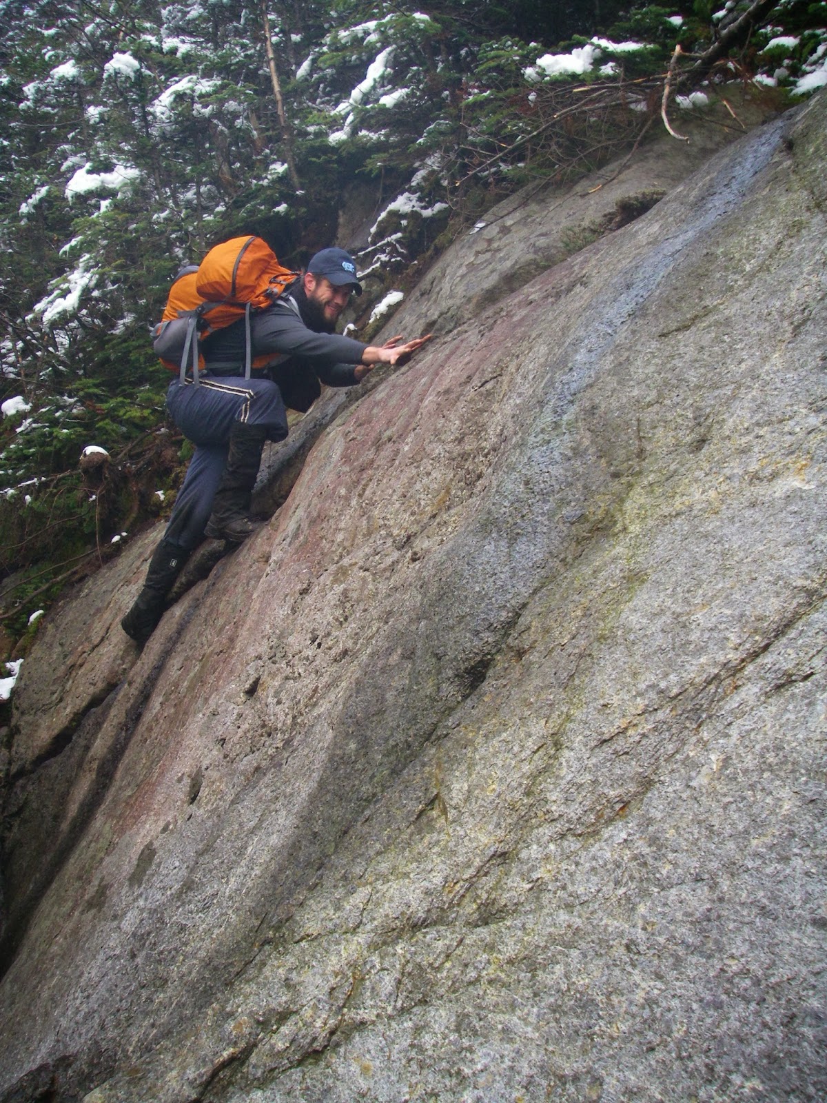
We shouldered overnight packs and headed up Johns Brook with a couple more days of adventure ahead of us. A few miles in, we dropped off extra gear at a leanto then began the long climb up to Basin. I remember that despite thinking I was in good shape, this climb really kicked my butt. Near the top it was seemingly a nonstop series of scrambles and waist high step-ups. But we rested on the summit and drank in the views, perhaps even more dramatic than those from Algonquin, and I already had a second favorite peak in the range! After lunch was the dramatic scramble up the open rock of Saddleback, supposedly one of the steepest bits of maintained trail in these mountains. The upper part isn’t really so much a trail though, as it is a scramble up bare rock with paint blazes showing the best way to go. As is often the case, I had built it up in my mind before the trip to be worse than it actually was, but that is better than the opposite. I would find that I had done the same thing on this year’s trip when we would be going down it. At any rate, it requires some care to travel and could be very interesting in bad conditions! More great views followed and soon we had our first really good views of Gothics. Gothics! What a great name for a peak, and quite possibly the best name for one in the East. It is certainly deserving of its name too, a hulking mountain ringed by great slides and cliffs, and from our perspective a steep-sided pyramid that beckoned for us to climb it. But it was getting late in the day, our progress had been slow, and we had spent too much time (or was it not enough?) on the summits of Basin and Saddleback. I hadn’t expected it to take 7 ½ hours to cover 10 miles! Discretion demanded that we leave it for another time.

Saddleback and Gothics from Basin.

Tommy Bell descending a tricky slab on Basin.

Climbing up Saddleback. Photo by Tommy Bell
On Day 3, we hit the trail from the leanto, earlier this time, and headed up again, bound for the highest peak in these parts. Though not without its challenges, this climb was less grueling than the last couple of days and we hit the top with perfect weather. We spent well over an hour on the 5,344’ summit of “Tahawus”, or the Cloud Splitter, as the Indians called it. If Marcy wasn’t especially difficult, the dramatic climb up the rocky crag of Haystack let us know that the norm was harder, not easier. But what a summit! Many consider this the be the best view in the Adirondacks. I was in no position to disagree then, nor am I sure I am now. The next morning we hiked out from the leanto and headed for Vermont and New Hampshire. I knew I would be back.

The awesome view of Basin, Gothics, and Pyramid from Haystack.

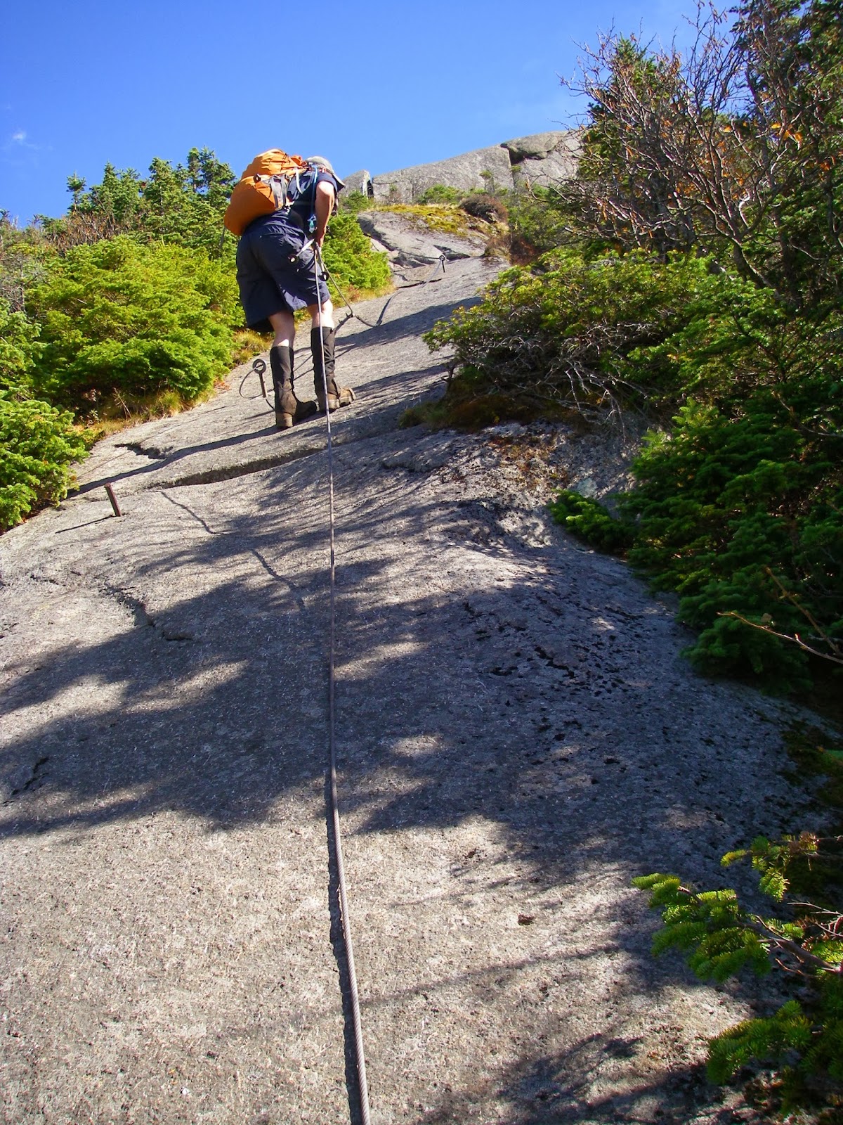
And so I was the next year. I had a couple vacation days left, so a cheap flight to Albany gave me most of four days to hike in the Dacks again. The first afternoon and the last morning I climbed the non-46er peaks of Pharoah Mountain and Noonmark respectively, both leaving me favorably impressed - especially the spectacular landmark summit of the latter. The two full days in the middle I filled with snowy, icy hikes of higher peaks. The first was a challenging loop over my remaining Great Range peaks. I had not been expecting snow and ice, and so I had not brought any traction devices with me. Once it got icy, I considered turning back, but kept easing higher and higher. Needless to say, the steep, bare rock of Gothics West Ridge was a bit intimidating with ice on it and me without crampons of any sort. I basically hauled myself up the cables anchored to the upper part, all the while desperately hoping I was not making a grave error and that the other side - without cables - would not be as  steep. Fortunately for me, it was not. I was in the clouds here, regrettably missing the views from this spectacular peak. I fared a little better on Armstrong and had some views of the summit I had just been on appearing and disappearing in the blowing clouds. From Upper Wolf Jaw I had some great views of the huge, barren slides on Giant and the Dix Range, then reached the col with time for a quick climb up Lower Wolfjaw as well, before heading down to the comforts of the valley. The next day was a cold hike to the marvelous summits of Giant Mountain and Rocky Peak Ridge. It started snowing pretty heavily by the time I headed down, and my descent was less than graceful, but it had been another grand adventure. With twelve of the Adirondack Forty-Sixers under my belt now, there was no question I wanted more!

On Armstrong.

Nippletop through the clouds, from Armstrong.

The Dix Range from Rocky Peak Ridge.

I returned again in 2004, when I had allotted four days of a larger two week trip to my now beloved Northeast, during which I did hikes in the Whites, Greens and Adirondacks, as well as in the waterfall country of the Finger Lakes Region. First up was an excruciatingly steep climb up to the open ledges of mighty Dix Mountain and its supremely dramatic subpeak of The Beck-horn, a craggy pinnacle of rock. It was simply a magnificent place to be, with blue sky and sun, and no wind - and stunning, exciting views in every direction, especially towards the Great Range. The next day was one of the harder hikes routinely done in the Adirondacks, that being up the narrow defile of the Trap Dike on Mount Colden. I chickened out at the crux twice, a narrow chimney where the route (no trail here) climbs almost vertically beside a waterfall, before encountering a group of four coming up. Two of them had done this before and were familiar with the route. They were generous enough to let me join them, and as it turned out, I had no trouble with the spot I kept turning back on. We ended up leaving the Dike for the slide too late, rather than too soon where it is dangerously steep. But instead, we ended up having to bushwhack through the trees part of the way to the summit. There was a bitter wind on top, but we found a sheltered spot to enjoy the jaw-dropping view across Avalanche Pass to Algonquin and the rest of the McIntyre Range. In the wind was a great view of Giant, Gothics, Basin, and Marcy. Day Three was a quick hike up the classic little Mount Jo before heading for the 46er peaks of Cascade and Porter. These are one of the exceptions to the long, gentle approach common to the Dacks and start out steep right away, making for a shorter, “easier” hike. It was a cold day and the high peaks, including these, were white with rime. Porter had great views, but they paled in comparison to those from Cascade. Cascade is one of those peaks like South Turner in Maine, that despite not being exceptional in its own form, brought so much majestic grandeur into view that I never wanted to leave. In fact, I sat up here in the sun, on a perfect little bench of rock sheltered from the wind for close to two hours, unwilling to avert my gaze from the hallowed peaks around me. It was like looking out the window of Heaven as I sat up here spellbound by the sublime beauty all around me in every direction, especially so looking South toward the giants of the range, Marcy and Algonquin looming above all else, the exhilarating climbs of Saddleback, Basin, and Colden, fearsome Gothics, and the peerless summit perches of Haystack and Dix. I would be on this summit again. And again! I had intended to finish this leg of the trip off with Whiteface and Esther, but opted instead for a shorter hike up the non 46er peak of Ampersand. It did not disappoint with its views of both big lakes and high peaks that I had yet to climb, including the Sewards.


The rugged Great Range seen from Dix Mountain.

Looking down at Avalanche Lake from partway up the Trap Dike.
Two years passed before my next visit in 2006, but this time I was back in the Northeast for a whole three weeks of blissful hiking and peakbagging in New York, Vermont, New Hampshire, and Maine. This time I had five days in the plans for the Dacks. The first day I did the lower non 46er peaks of Hopkins and Pitchoff, both wonderful hikes in their own right, but then it was more 4,000 Footers! First on the list was Whiteface, one of the most singular peaks in the range, looking like a steep-sided but pointy volcano from most perspectives. After a long stay on top enjoying the spectacular 360° views, I also bagged Esther on the way back down. This was followed with a rainy day hike of Phelps and Table Top. I was in the clouds atop the nice ledge on Phelps and may try it again one day. I feel no such compunction about Table Top which I wrote in my journal to be “Muddy, brushy, and not a fun climb at all to a wooded summit”. I decided against continuing on to Marcy for a second visit on such a nasty day. The next day, despite being overcast, was a glorious traverse of The Brothers with their nearly nonstop succession of views, ruining any chance of making good time. This culminated with a calf-burning climb to the top of Big Slide where I lingered for a decadent three hours in the very heart of the High Peaks, surrounded by their most impressive, most imposing peaks, smitten by their allure. And yet, it got even better! The last day was one of those magical days that I remember as one of my finest days in the mountains. Everything just clicked and fell into place. Great route, great mountains, great scenery, great weather, feeling strong and fast, no problems - just a great trek. I climbed the Macomb Slide to its namesake peak and made my way through the progression of South Dix, East Dix, and Hough. None of these are among the most dramatic in the Adirondacks, but all are rugged and steep and they all have their fair share of slides, open ledges, views, and challenging scrambles. I stayed on each briefly and relished the high ridges between. But it was from the summit of Hough, gazing up at the spectacularly sharp spire of The Beck-horn, that I decided to up the ante and turn a really good day into a really great day. I had been apprehensive about this hike from the start, wondering if I was biting off more than I could chew with its slide climb and herd paths. The urge to go UP THERE again, to what was already another favorite, was irresistible and I decided to take another bite. I was glad I did.


A rugged ridge just below the summit of Whiteface.

I couldn't resist climbing Dix again when I saw its subpeak, the Beck-horn from this angle!

The Beck-horn from above, on Dix, easily one of my favorite Adirondack peaks.
Only a year went by before I was in the Dacks again, this time with +Leanne. New York is her home state, she having grew up in Kingston at the edge of the Catskills, another range I have come to love. It was great to do some hiking here with her. The first day was in the Catskills and the last day in Vermont, but that left five more great days in the Adirondacks. Not all of our days were together, nor were all of them 46ers, but I still picked up five new ones for the list. We did a great hike up Hurricane Mountain, then the next day I got my ass kicked doing a near 20 miler for Colvin, Blake, Nippletop, and Dial. Unfortunately, I was mostly in the clouds and would like to someday do Colvin and Nippletop again. Day Three had Leanne and I going up Cascade and Porter, her first time and my second - but not my last up this great duo. I also went up pointy little Owls Head afterwards, something Leanne would do on her own the next day while I climbed Algonquin once again and also made it to the top of Iroquois. I don’t know how Tommy and I missed the herd path on that first visit, because it was pretty obvious. The top of this one made my 30th peak for the list, meaning I was two-thirds of the way done. I think this is when I really started to believe I might actually finish them in a few more years. After enjoying the awesome views for an hour-and-a-half, I headed down to Lake Colden and out, the initial descent so steep I had to laugh out loud in places. Our last day was another non-46er hike, again up the superb peak of Noonmark, one of the finest sub-4,000 foot peaks in the Northeast by my reckoning.


Upper and Lower Wolf Jaw from Nippletop.

Pitchoff Mountain from Cascade.

On top of Iroquois, Number 30 in the pursuit of the 46ers!
By now it should be obvious that I have a tendency to visit several areas in the Northeast on a trip if possible. Such was again the case in 2009 when I went to New Hampshire and Vermont with +David Socky  and Tommy Bell. I think it rained (or snowed) every day of the trip except for two or three, or at the very least, the summits were in the clouds most of the time. We even had several inches of rime and high winds on Mount Washington. Regardless, we spent the last two days in the Adirondacks. Less than stellar weather made us decide to do a couple of lower peaks the first day, and we actually ended up having a great day scrambling up Catamount, and seeing some of the most amazing Fall colors I have ever seen on our hike up little 2,427’ Baxter Mountain. The next morning saw us hiking in rain, sleet, and snow as we headed for Feldspar Brook and Lake Tear of the Clouds. Luck was on our side though, and as we neared the top of the cliff and mudhole-ridden herd path up Gray Peak, we could see patches of blue sky overhead. I hadn’t expected much in the way of views from this “summit”, yet here they were, and quite good to boot. Skylight followed, and it was glorious as we looked out upon a sea of Adirondack peaks from this open, alpine summit. Then, once again, I was atop Marcy, ecstatic, like a kid in a candy store as I excitedly pointed out this peak and that peak to Dave, by now quite a few that I had been on, but many, many more that I hadn’t and someday hoped to stand atop.


Adirondack mud.

Dave nearing the top of Mount Marcy.
It would be three years before I made it back once again, this time with my good peakbagging buddy +Peter Barr . This was a varied trip, one where we were after a number of other peaks besides 46ers, including peaks that were notable for their prominence or county highpoint status. I also did a number of peaks that would be repeats for myself, but that Peter needed for his just begun quest for the 46ers. He did have a start on them though, as he had managed to spend one day here only a month or so earlier and climbed Wright, Algonquin, and Iroquois. 

On our first day, we hiked the upper part of Gore Mountain after taking the gondola part way, then drove up Whiteface just so Peter could say he had been on top. He would return to hike it and several other key peaks the next Summer. We topped off the day with a great hike up Lyon Mountain. Both Gore and Lyon were county highpoints and firetower peaks we wanted, and Lyon was also a P2K. The next day was a spectacular repeat for me - all five of the Dixes. But this time the traverse was by a new route as we hiked up the Boquet River and then up the Great Slide on East Dix, an especially fun climb. It was a rewarding, but challenging day as we got caught by sleet and darkness on the descent from Dix, with the last several miles being in a cold rain that left several inches of snow on the higher peaks. The next day was my third time up Porter and Cascade and was perhaps even more beautiful than the previous trips as we encountered both snow and rime on top while gazing down on a kaleidoscope of Fall colors in the valleys below. After getting back down, we even squeezed in a quick trip to the firetower on little Belfry Mountain. We left Peter’s truck at the Rooster Comb trailhead and got a shuttle to the trailhead at South Meadow that night in preparation for an, as it turned out, overly ambitious beast of a day. We were going to attempt a one day traverse of the entire Great Range, including Gray and Skylight along with Marcy, Haystack, Basin, Saddleback, Gothics, Armstrong, and both of the Wolfjaws - a variation of one of the great Northeast “Death Marches”. 

To do this 26 plus mile day with over 10,000 feet of cumulative elevation gain, we were on the trail a few minutes after 2 am., truly an alpine start in the hopes of reaching the summit of Gray by sunrise to maximize our daylight hours on the peaks. We set a modest pace with the intention of conserving energy, but even so we started falling behind schedule early, missing our goal for Gray by about a half hour. By the time we climbed Skylight and Marcy, we were even farther behind but still hopeful. A bright note was that as soon as we stepped onto the cold, windy, cloud-shrouded summit of Marcy, Peter completed all of the Highest 100 Eastern Peaks as well as all of the Eastern Fivers! By the time we reached Haystack, it was starting to clear up a little, but I was pretty sure we were not going to make it. The hardest peaks of the day were still ahead and we were way behind schedule. The back story is that Peter had broken his ankle a few months earlier in Colorado but continued to hike on it. This particular trek was taking a major toll on him and he was in excruciating pain, especially if he stepped on anything wrong. He was committed to trying to finish, but by the time we reached the junction to continue up Basin I convinced him that it was in our best interest to bail. So down to Johns Brook and out we went. Despite saving another 3,000 feet of steep climbs and descents over six or seven more peaks, we still ended up doing a 23 mile day with some 7,200 feet of climbing! Despite his taking the next rainy day off while I did a short hike up Big Crow Mountain, Peter and I ended up still doing three more days of not at all easy hiking. Day Six was a challenging hike in the Seward Range to climb Donaldson, Emmons, and the namesake of the range. Seward also happens to be a county highpoint, and not just any county highpoint, but one of the Eastern 50 Highest county highpoints. And as it turned out, it happened to be the last one I needed to complete that list. So we had another mini celebration, just as we had on Mount Marcy for Peter’s completion. Day Seven was a bit of a kick in the teeth as we made adjustments for bad weather and snow. Instead of a long, hard day for the Santanonis, we decided for a short, easy day to do Street and Nye. The hike, though only about nine miles, turned out to be anything but easy in the freshly fallen 6-8 inches of snow. It was steep, slick, and wet and took a disproportionate amount of time and effort. Our last day was a spectacular finale up the non-46er peaks of Blue and Snowy Mountains, but I had picked up five new ones and Peter had gained sixteen, not counting Whiteface which we drove up. This left me needing nine peaks to finish the 46ers, while Peter still needed twenty-seven. He would knock out nine of those on a visit this past summer, including Whiteface, Esther, Phelps, Table Top, Big Slide, Colvin, Blake, Nippletop, and Dial. Bob Marshall, a man who was well known for having done 50 mile day hikes, and up to 14 Adirondack peaks in one day had also figured prominently in this trip, as we made repeated exaggerations of his prowess as a hiker - and as a man, sometimes even getting quite ribald. Disregarding the latter out of politeness, we joked about how he had once done a Great Range Traverse with a broken leg. And about how he had a bearskin rug in his cabin. The bear wasn’t dead. It was just afraid to move!


Peter Barr climbing the Great Slide on East Dix.

A ledge with a view on East Dix. Photo by Peter Barr

Seasons collide on Cascade Mountain.

Peter Barr on a typical herd path problem in the Dacks, this on the way up Gray Peak.

A few other lists were completed along the way while doing the 46ers. Among them, Peter Barr completed the Eastern Highest 100 Peaks atop Mount Marcy. I finished the Eastern 50 Highest County Highpoints on Seward and the New York P2Ks on Santanoni.

Naturally this way the way we went to climb the three peaks of the Seward Range!
Not all Adirondack peaks have great viewpoints, but with a little extra effort...

...they are usually worth climbing anyway - the Sawtooth Mountains seen with a tree assist.

Part 3 will describe the most recent trip, where Peter and I both completed our quest for the Adirondack 46ers. Until then, below are more pics from the trips described here:


Northeast 2004 (coming soon)

Northeast 2006 (coming soon)