Showing posts with label Best Unknown Hikes of Southwest Virginia. Show all posts

Saturday, January 4, 2014

Griffith Knob and Peak 3681 - Unknown And Unnamed Isn't A Bad Thing


Griffith Knob and Peak 3681
All of the best hikes are not documented. Sometimes I think about writing a small booklet titled “The Best Unknown Hikes of Southwest Virginia”, or something similar to that, and having a listing and descriptions of local favorites, close to home but worthwhile outings, and obscure but great locales that may be either on or off trail. They might be long or short, difficult or easy, but the one thing most would have in common is that while some may be well known locally, they have been rarely or perhaps even never documented on anything other than a limited scale. Regionally well known hikes like Mount Rogers and The Cascades would not be included in this category unless they were incidental to a lesser known nearby spot, though it might be somewhat subjective on my part as to what is well known and what is not - and what is worthwhile. Most might not make it onto a list of the best hikes in the Southern Appalachians (though some could), but all would be worthwhile and of interest to someone in the area who didn’t want to drive several hours to a good place to hike, or didn’t want to be gone all day. Most of the hikes would be on public land, but if I knew that a landowner welcomed hikers, then some destinations could be on private property. Whether or not such a book ever comes to fruition, it occurred to me that I can pursue that idea in this blog from time to time. One such hike would be Peak 3681 and 3,782’ Griffith Knob in Wythe County, a half day (or less) hike little more than 20 minutes away from my home in Wytheville.

These two peaks are on Brushy Mountain, located in the northern part of the county only a few minutes from U.S. Highway 52, and are within Jefferson National Forest. Respectively, they are the seventh and fifth highest peaks in the county, and the higher Griffith Knob is also the most prominent peak in Wythe County. It should be pointed out that part of this hike is quite steep and on very faint trails, and part of it is completely off-trail, albeit in relatively open woods. As such, it is probably best done in cooler and less vegetated months. The views will also be better then. It is also easy to do only Peak 3681 for a round trip of only around two miles, though because of the route, there is little reason to not include the short side trip to the top of this one even if the primary goal is only Griffith Knob.

Mount Rogers and Whitetop from Peak 3681.
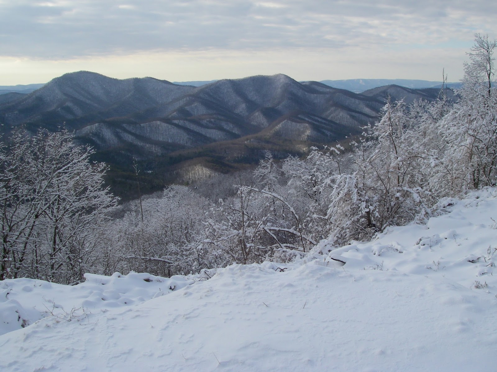
The hike begins at an unmarked pullout on FS 221 only a couple miles from Deer Trail Park. There is an obvious but unmarked path at first, perhaps made by hunters, that starts at the upper end of the parking area, and immediately begins a moderately steep 700’ climb up one of the northeastern ridges of Peak 3681 to the main crest between the two peaks but high on the shoulder of Peak 3681. The path becomes increasingly difficult to see as you climb higher, something to be well aware of for the return trip when it will be surprisingly easy to veer off onto the wrong ridge, but as long as you stay on the crest of this spur ridge going up, you will get to the right spot, hitting the main crest at about the 3,500’ elevation. Take special care to remember this exact spot. From here, turn west and continue upwards less steeply for another 3/10 mile to the top of Peak 3681. There are no wide open views here, but there are at least three spots with limited but pleasant views in different directions. From very nearly right on the summit, there is an outlook to the northwest of Walker Mountain, and peeking above its spine are the more distant and higher peaks of 4,409’ Chestnut Knob and 4,710’ Balsam Beartown, both on the rim of Burkes Garden. A few yards down the northern ridge is an outlook to the east that takes in the valley of Stony Creek between Big Walker and Little Walker Mountains. To wrap things up, one can wander perhaps 50 yards down the southern ridge and find a couple of decent sized openings in the canopy that allow some nice views of Mount Rogers and Whitetop, as well as a swath of the Iron Mountains. Again, none of these views are wide open, and they will be better when the leaves are off the trees - but they are all pretty pleasant scenes and ones that I find quite appealing.

Admiring the view of Stony Fork Valley and Little Walker Mountain from Griffith Knob.

After taking in the views, simply return back to the spot where the crest of the ridge was attained on the first leg of the hike - and again, remember it well, as it is easy to miss. At this point, you should head downhill about 1/10 mile along the southeastern ridge, losing a couple hundred feet of elevation, then regaining it to the top of the next unnamed knob at 3,640'. At this point, continue eastward on an old woods road, losing only about 50' before making a final 200' climb up Griffith Knob. It should be mentioned that the rest of the route is on the boundary between National Forest and private property, so don't please don't wander off the ridge crest to the south or east. There is no view from the top, but this is the most prominent peak in Wythe County and knowing that gives a certain satisfaction of its own if one cares about such things. Incidentally, when viewed from several miles away to the east, especially when the leaves are off and there is a bit of snow on the ground, the broad top surrounded by steep slopes and horizontal rock banding give this mountain a very “Catskillian” look that is quite impressive.

The conspicuous peak of Floyd County's Buffalo Mountain seen from Griffith Knob.


One might as well have the views too though. About ¼ mile down the north ridge, where it begins to narrow and then drop off more abruptly, there is a small clifftop opening a few yards off to the right. This is easily the best view of the hike, with an open arc of the landscape to the east and southeast. Little Walker Mountain, Queens Knob, and Sand Mountain are all in plain view and the solitary volcano-like and symmetrical form of Floyd County's Buffalo Mountain is very conspicuous to the southeast on a clear day, despite its being 44 miles away. This is a great spot to hang out for a while and enjoy what will almost certainly be complete solitude. On the return trip, hope you were paying enough attention to your route to avoid going down the wrong ridge anywhere, something that would be very easy to do in at least four different areas. A recorded track on a GPS could be much appreciated now, but it is still better if you made a mental note of key direction changes on your way here.
This hike is not going to attract crowds of people from all over the Southeast, or even the state. However, if you live within an hour or so, and are looking for something new and different, but not without some rewards, this is one of those little known hikes that can fit the bill. There are many more...


To see the topo map larger on this site, click on the map. Or click here to see it on CalTopo.


Elevation profile for this hike.

Hike stats: 4.2 miles, 1,950' cumulative elevation gain

More pics:

Resources:

Trailhead coordinates: 37.0120, -81.2283


created with Chrome OS

Sunday, December 1, 2013

Comers Rock - Earning Your Views


There are often days when I am not especially motivated to go hiking, but feel like I should get out in the woods for a few hours anyway. These same days, I usually don't want to be gone all day, nor do I want to drive very far - generally no farther than thirty minutes away. While I’m lucky enough that there are a few very nice destinations that close to home, that distance nevertheless really limits the choices, and while a lot of the hikes that close are pleasant enough, most are little more than a walk in the woods. There just aren't very many spectacular destinations really close by. Some may be nice enough otherwise, but lack appeal because there is also a road to or near the final destination. That usually takes away any feeling of remoteness out wildness, and usually makes one question why they are hiking up, when they may well encounter hordes of people who drove up. And while I myself am not averse to driving up certain peaks on occasion, it’s rarely as rewarding as a good hike to the same place.

Such is the case with Comers Rock. One can drive to within a hundred yards or so of the top, a fact that often makes me discount it as a "serious" hiking goal. But I always forget just how good views actually are from up there on a clear day, and they are even better when you earn them by hiking up. And despite the proximity of a road, there are no"hordes". Besides, it's a pleasant hike anyway, if the chosen route is through the Little Dry Run Wilderness located to the north of the mountain. For the best part of the first three miles, this trail follows the namesake creek of the Wilderness (a rather grandiose term for this little 2,858 acre parcel), a tiny little stream with gorgeous hemlock lined banks, and small pools and undercut banks that harbor native brook trout, some of the prettiest freshwater fish there are. Finding their haunts was one of the original motivations for my interest in hiking. Though I don't fish for brookies any more, I still love visiting the beautiful places they live.


Tommy Bell along Little Dry Run. While not from this particular hike, it shows how pretty the area is.
The hike starts with an unbridged crossing of Dry Run. If the creek is low enough to rockhop here, then the rest of the hike is probably not an issue. If it’s really high, you might want to come back another day. The trail follows Dry Run upstream a very short distance, then sidehills back to the North and West to reach Little Dry Run. It crosses this smaller stream numerous times, and is a bit vague in a few spots, but as long as the creek is near, so is the trail until one reaches the uppermost headwaters - and if one avoids the trailless northern tributary at the 1.4 mile mark. On another note, it was near this spot a few years ago that I turned off the trail to climb Peak 3,300, the last summit I needed to have climbed all of Wythe County's 43 ranked peaks. That adds another element to my fondness of this area. As the stream dwindles to a trickle, the trail steepens and climbs to a broad saddle to intersect the Virginia Highlands Trail. This makes an appealing return route by following it back to the highway, but the way to the top avoids it and continues straight across, onward and upward from this divide that separates Little Dry Run from Jones Creek. While it is never really steep, the remaining mile-and-a-half is decidedly uphill. Very close to the end, after all one’s work to get here, the trail disappointingly deposits one onto the gravel Forest Service road going to the same place. However, after only a hundred yards, it ends and a set of rustic stone stairs lead the remaining steps.  At least the final 150 yards is foot travel only, so there is some solace in knowing that even if you share the summit with other people, you don’t have to share it with their vehicles as well. And you know they didn’t see the pretty places you were privileged to see on the way up. As it turned out on this visit, I had the top all to myself the whole time I was here.

Brumley Mountain, Middle Knob, and Beartown on the horizon.
The summit has a couple of attributes of interest to only to peakbaggers. At 4,100’ in elevation, it is one of Virginia’s 97 ranked Four-Thousand Footers, coming in as the 62nd highest peak in the state. As it is the only peak over 4,000’ in Wythe County, is also the county highpoint for my home county. For everyone else, there are the views. The top has a few rock outcroppings, as well as a deteriorating viewing platform. Even though the railings are falling off and trees have been allowed to block the view to the West, this low platform offers quite a dramatic prospect. Starting in the Northwest and turning clockwise all the way back to the Southwest, the phalanx of mountains marching around the horizon includes a distant Brumley Mountain, Middle Knob, mighty Beartown Mountain, and White Rock on the Clinch Mountain massif. Closer in is Glade Mountain and its associated ridges as well as the sixty mile long sweep of Walker Mountain. Beyond it, to the North, are cliffbound Knob Mountain and Wynne Peak, as well as Chestnut Ridge, spruce-clad Balsam Beartown (sixth highest in Virginia, and the highest that isn’t part of the Mount Rogers massif), Garden Mountain, and East River Mountain. Most of Wythe County is in sight, and notable peaks include its most prominent peak of Griffith Knob, pointy Queens Knob, Cove Mountain, and its most isolated peak of Sand Mountain and attendant High Rocks, Lick Mountain, Stuart Mountain, Swecker Mountain, and Henley Mountain. This latter range separates the Cripple Creek and Reed Creek Valleys. Draper Mountain, Peak Knob, and High Knoll are next, while much farther to the Northeast are the high peaks of Sugar Run Mountain and Bald Knob, the latter over 50 miles away and Virginia’s most isolated peak. I can’t honestly say I have ever really looked for it, or if I have even been here on a clear enough day, but some research shows me that it should also be possible, at a bearing of 61°, and about halfway between Peak Knob and High Knoll, to see Apple Orchard Mountain from here as well. This is Virginia’s most prominent peak, and is nearly 110 miles away. If indeed it is ever visible, this would probably be one of the longest line of sight views possible in Virginia, if not the entire Southeast. It was clear on this most recent visit, but definitely not that clear. Much of the Eastern end of the Iron Mountains, of which Comers Rock itself is part of, extend as far as the New River. Things flatten out a bit on the rolling Blue Ridge Plateau to the Southeast, but a couple notable exceptions jutting up are Floyd County’s and Carroll County’s respective highpoints of Buffalo Mountain and Fisher Peak. To the south rise the considerably higher Grayson County peaks of Point Lookout and Buck Mountain, the eleventh and eighth highest mountains in the state. While not exactly in your face, the most dramatic view is probably to the Southwest. This would be the compact cluster of North Carolina mountains known as the Amphibolites. Among the rugged and spectacular peaks in view are Mount Jefferson, Phoenix Mountain, Bluff Mountain, Elk Knob, ragged Three Top Mountain, Snake Mountain, and the aptly named The Peak. Farther away are the glorious balds of the Roan Highlands. Quite an amazing collection of peaks really, but still not quite everything. By moving off the platform and onto the rocks nearby, one can look to the right of nearby Bald Rock Ridge and get a pretty good look at one of my most special places - the Grayson Highlands. Rising above First, Second, and Third Peaks are Virginia’s highest terrain. Big Pinnacle, Wilburn Ridge, and Mount Rogers are all in sight, and beckon as they always do. And by walking up, you earned the views, and can appreciate them even more. If you come in the Winter after a big snow, it might not even be possible for anyone to drive up even if they wanted to.

The eastern Iron Mountains. Floyd County's Buffalo Mountain is faintly visible near the center of the horizon.
The rugged Amphibolites of North Carolina, including Phoenix Mountain, Bluff Mountain, Elk Knob, Three Top, Snake Mountain, and The Peak.
Virginia's highest and most alluring terrain - looking towards Big Pinnacle, Wilburn Ridge, and Mount Rogers.

To see the topo map for this hike larger on this site, click on the image or click here to see it on CalTopo.


Elevation profile for this hike.

Hike stats: 9.9 miles, 2,000 cumulative elevation gain


Pictures from other visits to Comers Rock

Resources:

Trailhead Coordinates:  36.78855, -81.18327 
(trail begins across road from parking area, on West side of road)

Sunday, April 14, 2013

Middle Knob And The Great Channels - Maze In The Sky


I knew about the existence of one of the neatest places in Virginia for a long time before I was able to actually go there, despite the fact the trailhead was only an hour away. The Great Channels are a maze-like system of 20-40 feet deep interconnected crevices between huge sandstone blocks on top of the Clinch Mountain peak of Middle Knob. They have somewhat of the feel, on a small scale, of a cross between a Utah slot canyon and a cave. The moss on the walls, and the way the light filters down between the rock walls, sometimes coloring them red, adds a distinct enchantment to this small but rather unique area.

I first learned about this wonderful place sometime after the Nature Conservancy bought the five thousand acre tract containing it in 2004. Even then, with TNC wanting to preserve its pristine nature, it was not open to the public until 2008, when they sold it to the State of Virginia. Information on the best way to get to the Channels was sketchy at first, and required for some exploratory hiking on my part to get to them from the one public access point in Poor Valley - and it required a 10 mile hike with 2,600 feet of elevation gain. I wasn’t even sure of just exactly where they were even located on Middle Knob.


I've now been up there several times since that first visit, and it has become yet another favorite place of mine, well worth far more effort to get to - but the last few hikes have been much easier since the opening of a second trailhead on Route 80 at Hayters Gap, on the crest of Clinch Mountain at 3,017 feet. That’s the way +Leanne and I went today. It only requires a six-and-a-half mile hike with 1,200 feet of elevation gain from here, a small price to pay for such a big reward. The new, easy route starts out on a gated right-of-way that crosses private property for the first mile or so, but then enters into Channels State Forest for the rest of the way to the top of 4,208’ high Middle Knob.  The hike follows an old jeep road, presumably once used as the means of access to the still standing firetower on top of Middle Knob.


Beartown Mountain and Corn Valley from Middle Knob.
We were a little too early for Spring wildflowers this time, so the hike up was rather uneventful until we reached the top. But there is plenty to enjoy once there. First, we clambered up onto the large rock that forms the true summit and ate lunch in the sunshine and pleasant breeze of this perfect spring day, all while enjoying the great view of mighty Beartown Mountain just a few miles to the east. This hulking mountain is Virginia’s sixth highest at 4,689’ above sea level, and its large, balsam-capped plateau is, depending on the route used, one of the more difficult peaks in Virginia to get to, or arguably even in the Eastern US for that matter. It took me three tries to first reach the top, which I have now been to four times. Obviously, it has its rewards...

Virginia's two highest peaks in the distance.
The next attraction is the retired, but still standing firetower. It is in desperate need of refurbishing to be safe, and hopefully that will eventually happen, rather than it being dismantled - a fate that has befallen far, far too many of these magical houses in the sky. I can’t recommend climbing the tower, as the lower flight of stairs has been removed, and the rest look none too safe. That said though, I must admit that I couldn’t resist the urge to carefully make my way up above the trees to take in the jaw-dropping 360° panorama that it allows. On a clear day, the number of peaks in view is staggering. Besides the aforementioned Beartown Mountain and other peaks on the crest of Clinch Mountain, there are also notable prospects of Big A Mountain, River Mountain, House and Barn Mountain, numerous peaks in the rugged Amphibolite Range of North Carolina, as well as distant Grandfather Mountain and the Roan Highlands. The eye is also drawn towards the broad balsam-capped domes of Mount Rogers and Whitetop, towering over a thousand feet higher than anything else in the Old Dominion. After studying the horizon for a suitable period of time, I then looked down onto the top of the Great Channels only a hundred yards from the tower, their hidden passages not readily apparent from this perspective, but still beckoning for exploration.

Looking down on the Great Channels
Following the short path from the base of the tower to the edge of the rocks, we turned right and downhill along their eastern edge, following the obvious route into their depths. While there are other similar outcrops spread over a larger area up here, this best, most interesting section covers probably little more than a half acre. The first corridor opens into a 50 yard long passage between forty foot high walls that vary from maybe 6-12 feet wide. But they aren’t necessarily straight up and down. In places, they curve and interlock one way or another, at times blocking the sky from view, and obviously are part of the same rock that long ago split in half and separated. Moving down the corridor, there are intersecting passages laid out like intersecting narrow alleys between buildings. Some are only a foot or two wide, and a few are too small for a person to enter, but most are of an easy size to walk through. Nearing the perimeters, the blocks become lower, and the passages lead back out into the forest, but there are enough passages to explore to occupy an hour, especially on a first visit. They may even seem a bit confusing at first, but it doesn’t take long to figure out where to go and how to get back. And it doesn’t take long after the visit to want to come back again to this enchanting maze in the sky.

The base of the tower gives some idea of how the nearby Great Channels look from above, except they are much deeper.

Despite the limited area the cover, the Great Channels have a slot-canyonesque feel to them.

The crevice is about 30'-40' deep.

Route to Middle Knob from Hayters Gap. To see a larger map click here.

Hike Stats: 6.5 miles out-and-back, 1,200' elevation gain

Pictures from this hike

Pictures from other hikes to Middle Knob and the Great Channels
August 2012
October 2011
July 2011
April 2011
November 2010
May 2009
July 2008
May 2008


Resources:
gpx files and topo maps
Virginia DCR page for The Channels Natural Area Preserve
Channels State Forest brochure and trail map (opens as pdf)
Virginia Dept. of Forestry page for Channels State Forest
TEHCC page for The Channels Natural Area Preserve
EveryTrail.com Guide to The Brumley Mountain Trail
Tri-Cities.com article about Brumley Mountain Trail


View Larger Map
Hayters Gap trailhead coordinates:
36.86468,-81.94699

Google Map for trailhead

Scan QR code to navigate to trailheads with Google Maps on your smartphone


Saturday, April 13, 2013

Chestnut Ridge - Lonely Mountain Meadows


It’s hard to believe that such a nice spot on the Appalachian Trail as Chestnut Ridge is so lonely - not that I mind though. I kind of like it that way. I’ve been up there well over 60 times now, yes 60, but outside the peak of thru-hiker traffic I’ve rarely seen more than one or two people up there, and often-times no one else at all.

Besides comparatively little publicity, part of the reason for this lack of people is undoubtedly that it is relatively remote. The trailheads from the north (actually east) are on the rim of Burkes Garden, which isn’t exactly convenient from most of the main roads in the region. And one of the roads in to the Poor Valley trailhead on the south side has a hint of a third world feel to it, thanks a narrow dirt road with hairpin turns on a steep mountainside, with no guard rails and little room to pass another vehicle. For a while, a section of it had even slid away a few years ago, and that only added to the feeling. Even now, I’m always glad to get that section behind me. But this is also my favorite place to start the hike from, as I did today.

The trail starts off steep, eases up, steepens again, then moderates for the first 2 ½ miles to the ridgeline. This is a woods walk and is the price of admission to the great hiking above. Right before that second steep section is also one of my pet peeves about Appalachian Trail reroutes. There was a spot here where the level trail then climbed uphill at a modest grade to gain maybe 10 feet in elevation over a distance of perhaps 35 yards, before dropping off 6 feet of that gain over about 20 yards. It was a minor bump by any standard and insignificant compared to the steep section immediately ahead. But a 100 yard long section of brand new trail was built to sidehill around this tiny bump to end up at the same spot, saving a mere 6 feet of climbing. In the big scheme of things, it probably didn’t cost much, but there was labor and money for this while other trails go unmaintained or abandoned. I follow the new trail on the way down, but never on the way up, not that it makes any difference to anyone but me.

Once the crest of Chestnut Ridge is gained, the trail immediately comes out into a small meadow, and two more miles of easy strolling follow. The views are limited here, but hint at what lies ahead. After briefly re-entering the woods, the trail comes out in the open again near a small pond. As the trail climbs, there are good views to the south and west near here, but the best is still ahead. The trail goes into the woods once again, then emerges into a long, beautiful meadow with magnificent views, and the trail traverses its entire length. The scenery is great all the way through this clearing, but my favorite spot is about 300 yards before it enters the woods again, atop a small rise I like to refer to as “The Grassy Knoll”. The panorama here is more or less a 270° arc not counting the remainder of the still rising ridgeline, which, of course limits the view in that direction. To the south is the long ridgeline of Walker Mountain, with Glade Mountain, the Iron Mountains, and the Mount Rogers High Country beyond. More to the southeast, Sand Mountain is visible, which lets me know where home is. Southwest and west are Brushy Mountain, other high peaks on Clinch Mountain, and the cliffbound crest of Morris Knob. Finally, to the north, and much closer, is the spruce-capped top of Garden Mountain, a.k.a. Balsam Beartown. After the high peaks on the Mount Rogers massif, this 4,710’ peak is the sixth highest ranked summit in the state. Getting to it can be difficult if you don’t know the best approaches, but also an adventure with a high elevation bog and some great views nearby.

Looking south towards Mount Rogers and Whitetop, looming over a thousand feet higher than anything else in Virginia.

Peaks on Clinch and Knob Mountains.
The AT shelter atop Chestnut Knob
The high elevation bowl of Burkes Garden.
The long upper meadow on Chestnut Ridge.

I usually hate to leave this spot for the top, but always go there anyway because it has its own rewards. After another ¾ mile in the woods, the trail pops out in the open again and quickly reaches the top of the 4,409’ former lookout site. Unfortunately, the tower is long gone, but the lookout’s cabin still remains and has been converted to an Appalachian Trail shelter. If it’s cold and windy, or raining, the four walls and roof are always welcome. There are some views south and southwest here, though not as expansive as those from the Grassy Knoll. But there is one view here that the knoll does not have, and that is into the tremendous bowl of Burkes Garden. This 4 mile by 8 mile cove is called “God’s Thumbprint” and from above, or on a map, looks like a huge caldera or crater, though in actuality, it is not. Completely surrounded by Garden Mountain, and lying anywhere from 600 - 1,600 feet below it, its surprisingly flat floor is one of the highest inhabited valleys in Virginia, all of it above 3,000 feet in elevation. Were it not for the one small break in Garden Mountain that allows Burkes Garden Creek to drain out, it would not be a valley at all, but a huge lake. It is a curious place, to be sure. On this visit, the view of the Garden was actually something of a surprise. In the 20+ years I’ve been coming here, the viewpoint has slowly grown up with small trees and severely limited the view. But since my last visit, the Forest Service or PATH club that maintains this section of the AT has reopened the vista considerably. While it still isn’t a wide-open view, it should be good for several more years, especially in the brown months. Despite my disapproval of some reroutes, I am always grateful when something like this gets done. Keeping the views from these mountain meadows open keeps them special - though it may not continue to keep them lonely forever.


Route to Chestnut Knob from Poor Valley. To view a larger map click here.


Hike Stats: 9 miles, 2,000' elevation gain

Pictures from this hike 

Pictures from other hikes to Chestnut Ridge:
October 2011
April 2011
August 2009
May 2009
August 2008
October 2007
July 2007


Resources:

gpx files and topo maps 
Happy Trails article about Chestnut Ridge 
Blue Ridge Outdoors article mentioning Chestnut Ridge 
EveryTrail.com page for Chestnut Knob 


View Larger Map
Poor Valley trailhead coordinates:
37.02273,-81.4249

Google map for trailhead


Scan QR code to navigate to trailheads with Google Maps on your smartphone


Saturday, February 9, 2013

Clinch Mountain - The Back Of The Dragon


As I turned onto Route 16 North in the town of Marion, Virginia recently, I noticed a sign I hadn’t seen before proclaiming the road “The Back Of The Dragon”. While perhaps an appropriate moniker for this very curvy road that very nearly makes a complete loop at one point, I couldn’t help but think it was a knock-off on the section of US Highway 129 that winds around the western end of Great Smoky Mountains National Park. That is another exceptionally curvy road that has long been referred to as “The Dragon” or “The Dragon’s Back”. As it turned out though, the name seemed like a great way to describe the hike I was about to do. After a slow two dozen miles across Walker and Brushy Mountains, then up Clinch Mountain, I parked on the crest of the latter and stepped out into an icy wind to begin the day’s adventure. 

I had done the first two miles of this hike before, years ago, so I knew there were some good views, but I had forgotten just how spectacular this route was, and knew nothing about what lay beyond where I had turned around last time. Almost immediately the ridgeline narrowed down to a few feet wide, and soon thereafter small drop-offs began to appear on one side or the other. The crest became increasingly narrow, until it was literally a sharp spine of bare rock, usually with a cliff on the north side and a steep slope on the south. While the cliffs were nothing like you would expect on an alpine arete on a major mountain, they were certainly high enough in many places to demand respect and sure-footedness. Without trees, it would have felt a great deal more exposed in many spots, and a fall would likely be fatal in several of these. Occasionally it would widen out a little, but rarely for more than a few yards. There were bits and pieces of either game or hunter paths, but for all practical purposes this hike was, and is, a bushwhack. Briers were quite abundant, but rarely so thick that I couldn’t pick my way through them. Usually, I found I was able to walk right on the knife edge, but at times there were overly thick briers, or the exposure became too great for comfort. Almost without exception I was able to bypass such difficulties on the south side by dropping down a few feet or yards, often still on the steeply sloping slabs of sandstone, many of which extended a considerable distance downhill.

Much of the first four miles along the crest of Clinch Mountain varied from narrow...
...to narrower...
...to even narrower.
Can you say knife-edge ridge?

A natural arch.
 After about a mile, some limited views begin to appear, and a little farther there is even a small natural arch which is perhaps four feet high and fifteen feet long right on top of the ridgeline. Then the real views begin to appear in steady succession, and the route becomes even more interesting, literally like walking along the back of a dragon.  At various points there are views in nearly every direction, a couple of them essentially 360° panoramas. There is also one particularly notable overhang at one point, which looks like the famous overhang on McAfee Knob tilted upward at a crazy angle. It begged for a person standing on it in the picture, but alas, I was alone.

A crazy overhang ahead needed a person on it.
There were lots of nasty thorns!
Ease through some briers, walk a knife edge, drop down the south side a few yards to bypass a difficult section, climb back up, enjoy an awesome view. Repeat. This was the process for much of the first four miles. The views included such sights as Mount Rogers and Whitetop, Chestnut Ridge, Knob Mountain, and Thompson Valley among others. Eventually the crest starts to broaden and the last good view is at around the 4 ½ mile mark. This would normally be a good turnaround point, but I had another goal in mind.

Ever since my buddy Shane Ashby and I finished bagging all the ranked (300’ prominence) Virginia 4,000 Footers three years ago, and actually, all the 4,000’ peaks down to 200’ prominence, I have slowly been knocking off the few remaining named, but unranked 4,000 Footers as well, just to say I’ve been on them. One of the eight remaining was just over a mile ahead now. Redoak Ridge is 4,580’ above sea level, but it is certainly no peak, only a bump with 80’ of prominence on the ridge extending southwest from the state’s sixth highest peak of 4,710’ Garden Mountain, a.k.a. Balsam Beartown - a major Virginia summit with over 2,000’ of prominence. It has a name on the map though, so I wanted it. It also didn’t hurt my desire that the top was white with rime, and I could see that there was some snow up there. I started getting into snow just a little higher up, around the 4,000’ elevation. A little higher still and the rime started to appear in the trees, always a beautiful sight. Then, near the top, red spruce started to appear and I was again in my favorite type of forest - the boreal. No views, but a beautiful spot nevertheless. ( Actually, in hindsight, there may be more views nearby after all. Upon studying satellite imagery while writing this, I noticed that there appear to be more cliffs just to the north of my route, which could look into the head of Thompson Valley and beyond.)


Great view west of Thompson Valley, Peak 4150, Short Mountain, and Morris Knob.
 Half of the next ½ mile was pure Hell, as I dropped down to the headwaters of Cove Creek and climbed back up to Beartown Ridge. The rhododendron near the creek was pretty hideous. I don’t think I had to crawl anywhere or take my pack off, but there were a few places where it took me most of a minute to take one step. Pry back the interwoven branches, tuck them behind my back, grab a couple more, climb up into the bush and take a jerky step forward, then repeat. It was slow going, with a few choice words uttered aloud. Much to my relief, it eventually thinned out into more open woods and I reached the top of 4,689’ Beartown Ridge, another unranked bump, but one I had been on several times before.
Looking toward Virginia's two highest peaks, Mount Rogers and Whitetop.
Rime on top of Redoak Ridge.


A little snow and rime up high.
This hike would actually make for an adventurous route to get to Balsam Beartown (less than 1 mile away now) and even Hutchinson Rock, but certainly not the easiest one. I decided to forego it this time though, and bushwhacked down to Roaring Fork and back up onto the south end of Chestnut Ridge. Then I made my way down into Poor Valley and began the long roadwalk back to my vehicle, though I was lucky enough to catch a ride the last mile or two. I can’t say I would recommend the latter part of this hike to anyone unless they went to the effort to have a second vehicle waiting at the Appalachian Trail parking lot in Poor Valley. In that case, it could make for a long but awesome trek, potentially including Balsam Beartown, Hutchinson Rock, The Swag, and the section of the A.T. on Chestnut Ridge. Regardless of the longer option though, I am already looking forward to eventually returning here with a friend to once again walk the “Back of the Dragon”.

The route of this hike. To view a larger map click here.
  
Hike Stats:
My hike - 14.2 miles, 2,940' cumulative elevation gain
To last good view (#29) and back -  4.6 miles, 1,560' cumulative elevation gain

Pictures from this hike

Resources:
gpx files and topos 


View Larger Map
Trailhead coordinates:
37.04104, -81.51839

Google map for trailhead

Scan QR code to navigate to trailheads with Google Maps on your smartphone