Saturday, March 30, 2013

Dragons Tooth - The Fang of the AT


I may have walked along the dragon's back a few weeks ago, but more recently +Leanne and I climbed up to its tooth, or perhaps more accurately, its fang. This impressive little spire of upright sandstone atop Cove Mountain (actually a fin, not a spire - more on that later) is one of the so-called “Triple Crown” along this section of the Virginia Appalachian Trail. The other two are nearby McAfee Knob and Tinker Cliffs, and all three are spectacular destinations.

Cove Mountain summit and Dragons Tooth from Point 2363
The Dragons Tooth is probably the funnest and most challenging hike of the three, even though by our route it is the shortest. It ain’t Linville Gorge or Old Rag, but the 2 ½ miles to the top have some of the steepest, most scrambly terrain still traversed by the Virginia portion of the famous Georgia to Maine trail. That last sentence is a bit of a sore spot with me, because as time goes by, the Appalachian Trail gets rerouted. Sometimes this is for the better, as it has gotten the trail off of roads and into more scenic and less developed areas. But at other times, it seems the goal is to make the trail as easy as possible, and eliminate every steep bit possible, even if it means bypassing significant summits and worthwhile viewpoints. I’ve had a couple of rants about that in the past and may write a post about it here sometime. But for the time being, I think this section of the A.T. is relatively secure. At least I’m not aware of any intentions to tame it. Hopefully there never are.

This translates to "Fun Ahead!"
 Even without a view or a summit, a steep scramble is always fun and entertaining, and worth doing for its own sake. But here, on the climb up to the top of Cove Mountain, you are treated to all three. Nothing scary or difficult, at least not to most people - but hands may be needed for balance here and there, or to help get up a spot or two with a big step or a little exposure.

We started at the big parking lot for the Dragons Tooth trail on Route 311, rather than where the A.T. actually starts up the mountain on Route 624. There were already a lot of people here, but nothing like there would be later. On the way back down, we were rarely out of sight of at least one more group of people, and even had to wait our turn at a couple more restricted spots. The scene at the trailhead was then reminiscent of a popular Adirondack or White Mountains trailhead. The parking lot was full and there were cars parked up and down the shoulder of the road for a respectable distance. However, we didn’t see many people at first. Most who start here seem to go up the Dragons Tooth Trail, but we took the Scout Trail to the A.T. Not too far beyond this junction, the trail gains the crest of a ridge that leads to Lost Spectacles Gap. But before following it, we first made a short off-trail excursion to nearby Point 2363.
 

Perhaps my favorite part of this hike.
 This little unnamed, unranked summit has a rocky top with great views, and no people even though the trail comes within 250 yards. Indeed, even though I had seen it from higher above on the mountain every time I’d hiked to the Tooth, I had never been to this little crag until two years ago, when Leanne and I made the small extra effort to do so. As bushwhacks go, it’s pretty easy, with only a few briers, and a couple of easy scrambles between the trail and the top. There’s actually even a bit of a faint path part of the way. The views from the top are pretty much 360°, and surprisingly good for being only a few hundred feet above the valley floor, looking down the length of Catawba Valley and up to the Dragons Tooth atop Cove Mountain.

Back on the trail, it quickly gets more interesting as the trail steepens and moves onto a narrow rocky spine known as Rawies Rest. There are a couple of spots where a handhold is needed, at least for balance, and there are more views - though none as wide as from Point 2363. After crossing another minor summit, the trail drops off about 100 feet to Lost Spectacles Gap and the junction with the Dragons Tooth Trail’s upper end. This was one of the first really nice days of Spring, and here is where we joined the steady progression of people headed up to the same place. The trail stays mellow just a bit longer and passes the spot where the trail once headed straight up a spur ridge to the top of the mountain. I followed this route a couple years ago, and while I enjoyed its steepness, I must admit that its lack of views and scrambling makes this one of those cases where the new trail is vastly superior.
 

Typical terrain on the upper part of the trail.
 Beyond here the trail just gets better and better, steepening up and spending more and more time on rock. One of the neatest spots is a nearly vertical section of narrow, stair-stepping ledges that gains about 20 feet and offers a great view from the top. This is possibly my favorite part of the hike - it’s just exposed enough to feel a little risky, but is fun and easy. There are a few more steep sections and even a couple iron rungs placed in the rock to make it easier - though they aren’t really necessary. The trail eventually passes beneath the east side of the outcrop that forms Dragons Tooth, climbs a little more, and the fun ends, well almost. Just ahead, it tops out on the summit of 3,050’ Cove Mountain, where there is a great view east, even in spite of a little warm weather haze.

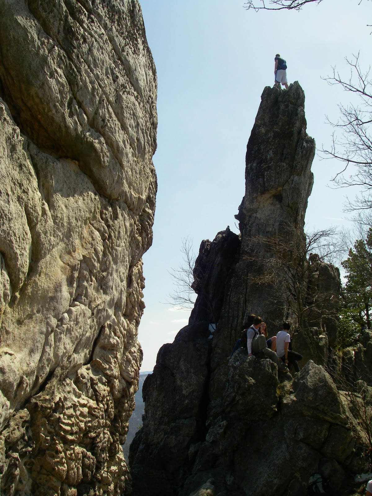
But the highlight of the hike, and its namesake, is a short distance down a sidetrail off the summit and the AT. Here, right on the very crest of the ridgeline, are a series of Silurian sandstone fins standing tilted upright at a nearly vertical orientation. They are at most ten feet thick near their tops, and the tallest of them - perhaps 50 feet high on the side you first see - is the Dragons Tooth. It drops off even more to the steep slopes below the east side, and at first it appears that the only way to get to the top is by rock climbing. It is somewhat of an illusion though, because the fin slopes down to the south. By walking around the right side, there is an easy way up to a notch in the fin and a crevice that leads back toward the top. You can either go under a chockstone wedged in this slot, then up, or stem up just before it. There is ample room and “safe” seating just above the chockstone for a great lunch and rest spot, and to take in the great 270° view that includes McAfee Knob and Tinker Cliffs - the other two-thirds of the Triple Crown. The Peaks of Otter are also visible 30 miles away and just to the right of McAfee Knob. Getting to the very top of the tooth is a different  matter. It’s only another 30’ or so away, but it gets intimidating quickly. The crest of the fin slopes upward somewhat steeply and narrows down to 4’ wide or less, and it overhangs on the west side. Few people have enough nerve to walk right up to the top. I usually sit about halfway up, and scoot the rest of the way while keeping secure handholds. I don’t go to the very top every time, and I’ve only been brave enough, (or stupid enough) to stand upright on the top once or twice and can’t say I recommend it to anyone - unless they are letting me take their picture, of course. You can probably only stand on the sharp end of a tooth so many times before it bites you. Not feeling overly brave (or stupid), I didn’t stand up today. Actually, I didn’t even go the the very tiptop, opting instead to stand and sit for a while on a narrow ledge on the east face. But there was another guy who climbed up after I had departed, who stood on top as nonchalantly as if he were standing on the ground. It made a great photo op and nobody got bit.
 

Another upright fin adjacent to Dragons Tooth.
The view of Catawba Valley with Tinker Cliffs (center) and McAfee Knob (right) above it.

Below Dragons Tooth, on the AT.
More fun trail.
Yes, this is the trail, my favorite part.


To view a larger map click here.


Hike Stats: 5.3 mile lollipop loop, 1,675' cumulative elevation gain

Pictures from this hike 

Pictures from other hikes to Dragons Tooth
April 2012
February 2011
May 2010
November 2009
April 2009
November 2008
November 2007
July 2007

Resources
gpx files and maps
Hiking Upward page 
USFS page for Dragons Tooth Trail
USFS page for Boy Scout Trail


View Larger Map
Dragons Tooth trailhead coordinates:

37.3789,-80.15606

Google map for trailhead


Scan QR code to navigate to trailheads with Google Maps on your smartphone


Saturday, March 23, 2013

Anthony Knobs and North Mountain - Caves and Cliffs

Near Pete's Cave. Photo by Dave Socky

I had another great day exploring new peaks and new views in the mountains of Virginia, and enjoying some old views again to share them with friends. Today I joined up with Tommy Bell and +David Socky to hike up Anthony Knobs in the Allegheny Highlands, then doing a second hike nearby.

Wanting to hike a loop over Anthony Knobs first, we found the road to the trailhead at the Longdale Recreation Area to still be gated and closed for the season. This would have necessitated an extra two miles or so of hiking on the road, but by driving a few more miles, we were able to start at an alternate trailhead farther south, along Sinking Creek.

Looking over the Cowpasture River Valley towards Rough, Mill, and Brushy Mountains from Anthony Knobs.
Only problem was that we couldn’t find the trail we were looking for which the map showed heading straight for the top of the mountain. We did find a trail, but it was a hideous tangle of blowdowns and we quickly decided we weren’t going that way. Back at the trailhead, we found what was apparently the other leg of the loop, heading back toward the first trailhead. We decided we would follow it and see where it went, and make any adjustments or bushwhacks that might be required to do the loop I had in mind. We soon turned uphill on an old woods road and seemed to be moving onto the shorter of the two possible loops here. It eventually turned into a footpath and didn’t seem to exactly match the map I had, nor had it been maintained in some time - but it generally went the right way, and I tend to enjoy following faint and abandoned trails, and seeing where they go. Sure enough we eventually gained the crest of the mountain and a trail sign.
 
Dave on a steep slope.
 The continuation towards the Longdale area was obvious, but thanks to a blowdown, it took a little looking to spot where it headed toward the top. After a short distance, it became a sidehill trail on a steep slope, not a ridgeline trail as the map showed. It kept going the right way though, and eventually ran onto another old woods road. This took us to the edge of the National Forest boundary and private property, but there are some views to the southwest from here, as this is the edge of an old clearcut. The steep-sided summit cone of the 2,460’ peak is also in view, but is just off of the National Forest. It is possible, however, to bushwhack up to the ridgeline along the boundary line and also get some good views to the north, towards Iron Gate, Griffith Knob, and the mountains around Douthat State Park.

The next challenge was finding a reasonable way down. There was absolutely no trace of a trail where the map showed one descending easterly along the boundary line, and we didn’t want to end up in the tangled mess we had attempted to start the hike in. Fortunately, Dave had noticed that his gps showed a trail a little farther northeast, which descended back to the valley. Incidentally, this trail is not on the USGS topo, the USFS topo, nor the Trails Illustrated map of this area. But, lo and behold, after spreading out across the hillside where it supposedly started, we actually found it.
Tonka getting a drink.
The upper part was faint, had a number of blowdowns across it, and varied a bit from what the gps showed, but it was there and even had some faded old blazes. It got a little more distinct farther down and eventually merged onto the trail shown on the paper maps - of which there was no sign of it continuing up the mountain. Surprisingly, and a bit embarrassingly, it came out right at the spot we had hoped to start the hike from, in the one spot we hadn’t looked at closely enough because there was a large mud puddle there. It even had a piece of flagging at the start which we had all three somehow missed seeing! But all’s well that ends well, and we headed for the next hike.
Tommy and I atop the cliffs of North Mountain. Photo by Dave Socky
I had done most of this hike once before with my girlfriend +Leanne, and Tommy had also been on the first half mile or so of it with me last year. But there is more to see, and farther to go. Big rewards come quick, as there are several spectacular cliff-top views south and east in the first 3/10 mile that include Big Butt, Big House and Little House Mountains, and many peaks in the Central Blue Ridge. This is followed by 2 ½ more miles of easy hiking on a nice ridgeline trail to an area of massive sandstone blocks that provide more great views, one of House Mountain from a different perspective, as well as great views north that include Anthony Knobs and many of the same mountains we could see from there. There are also a couple of large talus/fissure caves just off the trail in this same area. One is more of a narrow corridor between two blocks, open to the sky at first, with the back half under a roof and more cave-like, with a total length of perhaps 150’. The larger one, which we didn’t actually climb down into because of wet, muddy rock above a 10’ drop (I know, that’s a pretty lame excuse) - and assuming it is indeed the correct one - is known as Pete’s Cave, and supposedly has around 400’ of passage.
Dave in the fissure passage of "Not Pete's Cave".

We continued a few tenths of a mile farther and made a short off-trail jaunt to the top of Peak 3260, something I hadn’t done on my first hike here with Leanne. This is a so-called soft ranked peak, because based on the contours of the topo map it has an interpolated, or average, prominence of less than 300’, but whose same unknown true summit and saddle elevations could very well give it an optimistic or “dirty” prominence of over 300’. The number of such peaks is not insignificant. Virginia has a total of 1,554 ranked peaks, based on having a minimum of 300’ of average prominence. That is to say that if you wanted to compile a list of every true peak in Virginia ranked from highest to lowest, you would have a list that started with 5,729’ Mount Rogers in the #1 spot and 791’ Mount Pony at the end of the list at #1554. Wilburn Ridge, at 5,540’ is ostensibly the #3 peak , but it only has 160’ of prominence - a minor bump, not a peak - so it doesn’t count. However, there are an additional 169 of these “soft” ranked peaks that don’t fall within those rankings - but quite possibly belong there. If you’re working on completing a peaklist based on elevation, these are often nagging peaks that you wonder if you need to do “just in case”. Ah, the things peakbaggers worry about...
Dave in the jumble of talus near Pete's Cave.

But just because a summit isn’t ranked, that doesn’t mean it isn’t worth visiting. Not at all. Wilburn Ridge is arguably the most spectacular spot in Virginia, certainly one of them. Likewise, while Peak 3260 doesn’t deserve any such accolades, there was nevertheless a small outcrop at the very top that had some good views to the south, and a rather spectacular view of Big House and Little House Mountains, justification enough for climbing it in my book.

On the outcrops near Pete's Cave, with Anthony Knobs, Rich Patch Mountain, and Nicholls Knob in the distance.
 
Big Butt, Big House Mountain, Little House Mountain, and the distant Blue Ridge from Peak 3260.

The route of the Anthony Knobs loop. To view a larger map click here.

The route of the North Mountain hike. To view a larger map click here.

Hike Stats:
Anthony Knobs loop - 6.25 miles, 1,600' cumulative elevation gain
North Mountain and Peak 3260 -  8.3 miles, 1,360' cumulative elevation gain

Pictures from these hikes

More pictures from North Mountain
April 2012
October 2009

Resources:
gpx files and maps for Anthony Knobs
gpx files and maps for North Mountain
USFS page for the Anthony Knob Trail
USFS page for the Blue Suck Run Trail
USFS page for North Mountain Trail
Hiking Near Lexington


View Larger Map
Anthony Knobs trailhead coordinates:
37.75941,-79.71785
Google Map for trailhead

Scan QR code to navigate to trailheads with Google Maps on your smartphone:


View Larger Map
North Mountain trailhead coordinates:
37.819,-79.63468
Google Map for trailhead

Scan QR code to navigate to trailheads with Google Maps on your smartphone:


Saturday, March 9, 2013

Big Bald - A Commanding Prominence


Wow, where does the time go?! I can’t believe it’s been five years since my last visit to Big Bald - too awesome a spot to visit that infrequently. Big Bald, at 5,516', is one of the better peaks in the Southeast, making both the Southeast Highest 100 list at #59, and the Southeast 50 Most Prominent at #10. But on top of that, the summit is a grassy bald with spectacular views in every direction. This was another great hike with my buddy Tommy Bell, and we couldn’t have picked a better day for it.

 We started seeing snow along the side of the road a couple miles before reaching the trailhead near 3,252’ Spivey Gap. The snow cover was continuous there, and only got deeper as we gained elevation. It was a fairly tough 15 miles, with up to as much as 18" of snow up high, except on the bald, where the wind had scoured it clean. There were some older tracks, but we still had to do quite a bit of postholing and I regretted not having brought my snowshoes.

We had some good views from High Rocks, the first peak the AT goes over on the way, and also found a nice, if limited view from Little Bald (which is not bald). But the big reward comes at the very top of Big Bald. This open summit is every bit as exposed as the alpine summits of the Northeast and can be dangerous in bad weather, but not today. This was a crystal clear day with blue sky and 80+ mile views that dictated spending over an hour on top identifying peaks all around the horizon and getting sunburned in the process. Though the wind had at some time scoured the top mostly clean of snow, there was little or no wind today, the temperature was above freezing, and we were able to lounge in the grass while soaking up the sun and taking in some of the best panoramic views in the Southern mountains.
The Bald Mountains from High Rocks
 
 
The dominant feature is probably the nearby crest of the Black Mountains, with its line of peaks above 6,000’ that culminates at Mount Mitchell, the highest peak for 1,200 miles. The rest of the horizon is like a who’s who of the Southern Appalachians. Just a few among the visible sights include the Great Craggies, the steep cone of Mount Pisgah, the Great Balsams, the Plott Balsams, the Newfound Mountains, the Great Smokies (with 6,621’ Mount Guyot very obvious), the Bald Mountains, the Iron Mountains, Unaka Mountain, Mount Rogers, part of the Amphibolite Range, the Roan Highlands, Grandfather Mountain, and Hawksbill and Table Rock on the eastern rim of Linville Gorge. One can also see across the Tennessee Valley to the Cumberland Plateau, Bays and Chimneytop Mountains in Tennessee, as well as Virginia’s Powell Mountain, Clinch Mountain, and even Big A Mountain some 78 miles away. I didn’t try to pick it out, but another hiking buddy, Tom Layton, pointed out that even Cumberland Gap is visible from this amazing vantage point. That would be a little over 70 miles to the northwest on the Virginia and Kentucky border. Also, it would seem that Black Mountain, the highpoint of Kentucky, is also in sight 68 miles away at a bearing of 340°. Not only that, but according to Peakfinder.org, several South Carolina peaks, including Caesars Head (62 miles), Pinnacle Mountain (68 miles), and Sassafras Mountain (66 miles) are also visible to the south. If so, that means that five states are visible from this commanding prominence. In all likelihood, some of the most distant landforms we could see on the horizon were pushing the 100 mile mark. With a spotting scope, and a day like this, it seems quite likely that one could even pick out some of the tall buildings in Charlotte by looking immediately to the left of Celo Knob. That would be 104 miles or so away! I’ll have to try to confirm that if I’m ever lucky enough to be here on another equally good day.

Tonka and Tommy taking it easy on Big Bald.
Looking northeast towards Unaka Mountain. Mount Rogers was just visible over Unaka's shoulder, some 70 miles away.
The Roan Highlands
A two shot panorama of the Black Mountains and the Great Craggy Mountains from Big Bald. Click to view larger or go to the album.
The view to the southwest from Big Bald takes in the Eastern Smokies, including Mount Guyot. The obvious snow-covered bald is Max Patch Mountain.

The route of this hike. To view a larger map click here.

Hike Stats: 14.8 miles, 4,200' cumulative elevation gain

Pictures from this hike

Other pictures from hikes to Big Bald
March 2008

Resources
gpx files and maps


View Larger Map
Trailhead coordinates: 36.03169,-82.42004

Google map for trailhead

Scan QR code to navigate to trailhead with Google Maps on your smartphone