Showing posts with label North Carolina. Show all posts

Saturday, April 20, 2013

Gentry Falls, Rogers Ridge, and Glenn Bald


The Gentry Creek Trail is one of the lesser known gems in the Tri-State area where Virginia, Tennessee, and North Carolina all meet. When combined with Rogers Ridge and Glenn Bald, it makes a great, little known hike of 14+ miles with lots of creekside walking, wildflowers in the right season, a great little two-tiered waterfall, and great views from a near 5,000' peak.

Though I've now done this hike several times, the one time I tried it with Tommy, we came in the Winter. The creek was frozen over and we gingerly walked across the ice at every one of the many crossings enroute to the waterfall, hoping not to fall through. It started snowing, and we decided against going up on Rogers Ridge that time. We were back for unfinished business today.


One of many crossings of Gentry Creek.
Gentry Creek was running pretty full, and some of the many unbridged crossings that came in fast succession were a bit challenging to keep dry feet on, but for the most part, we somehow managed to do so. Well, at least Tommy and I did. Tonka got wet , but being a dog, she didn't seem to mind. I think there were 23 crossings of Gentry Creek in all, plus a couple of smaller tributaries!

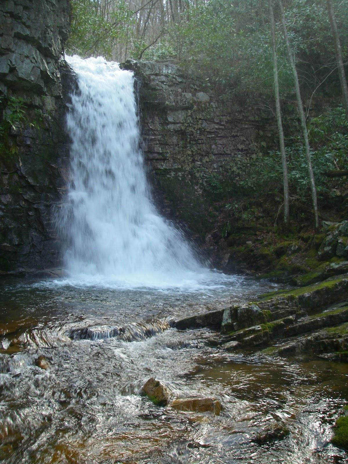
Along with the beauty of the stream, we were also treated to the sight of lots of Dutchman's breeches and erect trilliums in bloom. Then, after about three miles, we finally reached the reward of Gentry Falls. This two-tiered beauty is always a nice sight, although getting a good picture showing just how neat it is proves difficult. It is impossible to get both falls in without a lot of foreground clutter and the crazy tilt of the rock strata always makes the picture look crooked even though it isn't. At any rate, there are two vertical plunges here. Both are around 20 feet high and separated by about 50 feet of horizontal stream. Actually, with the creek as full as it was today, the lower falls spill over the cliff's edge as two parallel cataracts of whitewater. This may be the first time I’ve seen more than a trickle coming off the left side, and it was quite pretty.


Dutchmen's breeches
The route for getting past the falls is fun too, especially the ledge/ramp that climbs above the upper falls. It is not obvious, but one has to cross the creek again right below the lower falls, then follow the base of the cliffs steeply uphill for maybe 50 yards, until reaching a notch in the clifftop that can be stepped up into. This leads back down to the creek between the two falls. The rock is sloping here, moss-covered, and very slick, so care is in order if you go down to the water's edge. It would only take one wrong step to end up going over the lower falls, and it would most certainly leave a mark. There is a great view of the upper falls from this hidden  enclave though. By going uphill to the right, along the base of the cliffs at the upper falls, one comes to a narrow ledge that traverses up and back to the top of the falls, allowing them to be passed - but this is another spot you wouldn’t want to fall.


Upper Gentry Falls
Above the falls, the trail is less obvious, and apparently less travelled. But after about a mile, and several more creek crossings, it finally veers to the left and climbs away from Gentry Creek and up to the crest of Rogers Ridge. The trail there is an old woods road, and at least one section of it climbs quite steeply along the spine of the ridge, eventually coming out in open meadows with a view of the final destination still a mile ahead ahead. That destination is the 4,980’ summit of Glenn Bald, the highest point on the Stone Mountain/Pond Mountain massif. Before getting there, we climbed to the top of Rogers Ridge, only 100’ lower, and with views nearly as good, though somewhat lacking to the north. We didn’t bother going to the outcrops on nearby Catface Ridge, but there are some views there that add to what can’t be seen from Rogers Ridge. However, as good as the views are from here, there is little, if anything, that can’t be seen from the higher summit of Glenn Bald. This high peak just barely misses being another Southern Fiver, with it and nearby Pond Mountain being the only two peaks between Mount Rogers/Whitetop and the Amphibolite Range of North Carolina that are even close.
Whitetop and Mount Rogers from the top of 4,980' Glenn Bald

Until recently, Glenn Bald’s top was private property, but it has now been bought by the State of North Carolina, and is public land. There is still a house on top, once very nice, but now badly vandalized by idiots. I have been told that one potential use for the house may be as some sort of outdoor education center. Today though, it was very windy and cold up here at nearly 5,000’, so the house made a great place to get out of the wind and eat lunch, all the while looking out the upstairs window at Mount Rogers and Whitetop. Back outside, the open top provides about a 270° panorama around the horizon, sweeping from Pond Mountain in the southeast, to Mount Rogers and Whitetop, the Iron Mountains, the distant crest of Clinch Mountain’s many peaks, then swinging southwest to include the Bald Mountains, the Roan Highlands, Grandfather Mountain, and several peaks in the Amphibolites, the most obvious being The Peak, Elk Knob, and Snake Mountain.


Our return route was to simply stay on the Rogers Ridge trail, parallelling the route we had followed up Gentry Creek, but several hundred feet higher until reaching the south end of the ridge, where the trail then descends back to the valley for one final crossing of the creek and the end of another great day in the Southern mountains.

Rogers Ridge (left) and Clinch Mountain (horizon) from Glenn Bald.
Heading back down the open crest of Rogers Ridge. Gentry Creek lies in the valley to the left.


Gentry Falls-Rogers Ridge-Glenn Bald Loop. To view a larger map click here
Note: There seems to be a problem with the default map view I have selected not working. Please select the map you prefer from the drop-down menu in the upper right corner of the map.


Hike Stats: 14.3 miles, 2,800' cumulative elevation gain 

Pictures from this hike

Pictures from other hikes to Gentry Falls, Rogers Ridge, and Glen Bald
October 2011
March 2011
April 2008

Resources:
gpx, kmz, and topos
Appalachian Treks blog
Blue Ridge NC Guide
Sherpa Guides page
Johnson County Trails Association


View Larger Map

Gentry Falls - Rogers Ridge Trailhead Coordinates:
36.54491,-81.73866

Scan QR code to navigate to trailheads with Google Maps on your smartphone

Saturday, April 6, 2013

Grassy Ridge and the Roan Highlands - Fellwalking, Southern Appalachian Style

The grassy balds of the Southern Appalachians have sometimes been given the moniker of “Southern-Fried Tundra”, a name I rather like, but one that is also a bit misleading. While these open crests and summits can indeed have a somewhat alpine tundra-like appearance, they certainly are not alpine, and are often very near even higher peaks and ridges that are totally forested. Another term that might be justifiably used is fell. Fell is a term used in Great Britain, especially England, for an open, grassy mountain. While it is used as a blanket term to include their higher mountains, which are indeed alpine, it does not imply such, and includes lower hills that may have been tree-covered at one time, but are now open due to the effects of clearing and grazing over the centuries of habitation. The English are also a nation of walkers, and one of the terms they use for hiking in the mountains is fellwalking. I like that word too.

There is no better place to go fellwalking in the Southern Appalachians than than the crest of the Roan Highlands. There are literally miles of wide-open grassy balds and meadows here, including Hump Mountain, Little Hump Mountain, Big Yellow Mountain, Grassy Ridge, Jane Bald, and Round Bald. Spectacular views in every direction abound and my buddy Tommy and I recently started at 5,500’ Carvers Gap and hiked up the Appalachian Trail, which was still a ribbon of ice in the shade of the spruce trees on the west side of Round Bald. After coming back out into the open a couple hundred feet higher, we found only intermittent patches of snow and ice on the trail and surrounding meadows, the direct sun having melted it all away. Apparently the summits had been in the clouds the day or night before though, because the trees had a modest coating of rime. Though it soon started falling off as the morning warmed up, for a while it added a magical touch to the already wonderful scenery. We had views in every direction as we wandered over the 5,820’ summit of Round Bald, down into Engine Gap, and up again to the top of equally high Jane Bald.

Though we spent the day wandering along several more miles of scenic ridgeline, with some big ups and downs along the way, the high point of the day, literally, was the wide open top of 6,180’ Grassy Ridge Bald and its slightly lower, but more rugged southeastern subpeak. It’s an easy hike to here, and we probably spent well over an hour up here gazing around the horizon at the sea of peaks rising up from the lowlands. With the rest of the Roan Highlands all around and close up, even though it wasn’t as clear as it had been on nearby Big Bald a few weeks ago, we could also see part of the Bald Mountains, the high peaks of the Black Mountains and Great Craggies, Hawksbill and Table Rock on the rim of Linville Gorge, Grandfather Mountain’s ragged crest, Beech Mountain, and some of the peaks in the Amphibolite Range among others.

On Round Bald, looking at Little Yellow, Hawk, and Lightwood Mountains with Spear Tops, Big Bald, and Little Bald farther back.

Standing tall on Round Bald, looking at Roan High Knob.

6,180' Grassy Ridge ahead.

On Grassy Ridge, looking at Little Yellow and Hawk Mountains, with Spear Tops, Big Bald, and Little Bald farther back.

Rime-plastered tree on Grassy Ridge.

The Southeast summit of Grassy Ridge.

Balds of the Roan Highlands.

Heading back to Round Bald.

Route to Grassy Ridge. To see a larger map click here.

Hike Stats: 11.1 miles, 3,550' cumulative elevation gain
To Grassy Ridge and back only: 5.5 miles, 1,320' cumulative elevation gain

Pictures from this hike

Pictures from other hikes to the Roan Highlands:
Hump and Big Yellow Mountains - June 2011
Grassy Ridge - February 2009
Roan Mountain - June 2009
Hump Mountain - June 2008
Hump Mountain - October 2007

Resources
gpx files and maps
SummitPost page for the Roan Highlands
SummitPost page for Round Bald
SummitPost page for Jane Bald
SummitPost page for Grassy Bald
Roan Highlands Wikipedia page
Roan Highlands Nature Conservancy page

View Larger Map
Carver's Gap trailhead coordinates:
36.10645,-82.11033

Google map for trailhead


Scan QR code to navigate to trailheads with Google Maps on your smartphone


Saturday, March 9, 2013

Big Bald - A Commanding Prominence


Wow, where does the time go?! I can’t believe it’s been five years since my last visit to Big Bald - too awesome a spot to visit that infrequently. Big Bald, at 5,516', is one of the better peaks in the Southeast, making both the Southeast Highest 100 list at #59, and the Southeast 50 Most Prominent at #10. But on top of that, the summit is a grassy bald with spectacular views in every direction. This was another great hike with my buddy Tommy Bell, and we couldn’t have picked a better day for it.

 We started seeing snow along the side of the road a couple miles before reaching the trailhead near 3,252’ Spivey Gap. The snow cover was continuous there, and only got deeper as we gained elevation. It was a fairly tough 15 miles, with up to as much as 18" of snow up high, except on the bald, where the wind had scoured it clean. There were some older tracks, but we still had to do quite a bit of postholing and I regretted not having brought my snowshoes.

We had some good views from High Rocks, the first peak the AT goes over on the way, and also found a nice, if limited view from Little Bald (which is not bald). But the big reward comes at the very top of Big Bald. This open summit is every bit as exposed as the alpine summits of the Northeast and can be dangerous in bad weather, but not today. This was a crystal clear day with blue sky and 80+ mile views that dictated spending over an hour on top identifying peaks all around the horizon and getting sunburned in the process. Though the wind had at some time scoured the top mostly clean of snow, there was little or no wind today, the temperature was above freezing, and we were able to lounge in the grass while soaking up the sun and taking in some of the best panoramic views in the Southern mountains.
The Bald Mountains from High Rocks
 
 
The dominant feature is probably the nearby crest of the Black Mountains, with its line of peaks above 6,000’ that culminates at Mount Mitchell, the highest peak for 1,200 miles. The rest of the horizon is like a who’s who of the Southern Appalachians. Just a few among the visible sights include the Great Craggies, the steep cone of Mount Pisgah, the Great Balsams, the Plott Balsams, the Newfound Mountains, the Great Smokies (with 6,621’ Mount Guyot very obvious), the Bald Mountains, the Iron Mountains, Unaka Mountain, Mount Rogers, part of the Amphibolite Range, the Roan Highlands, Grandfather Mountain, and Hawksbill and Table Rock on the eastern rim of Linville Gorge. One can also see across the Tennessee Valley to the Cumberland Plateau, Bays and Chimneytop Mountains in Tennessee, as well as Virginia’s Powell Mountain, Clinch Mountain, and even Big A Mountain some 78 miles away. I didn’t try to pick it out, but another hiking buddy, Tom Layton, pointed out that even Cumberland Gap is visible from this amazing vantage point. That would be a little over 70 miles to the northwest on the Virginia and Kentucky border. Also, it would seem that Black Mountain, the highpoint of Kentucky, is also in sight 68 miles away at a bearing of 340°. Not only that, but according to Peakfinder.org, several South Carolina peaks, including Caesars Head (62 miles), Pinnacle Mountain (68 miles), and Sassafras Mountain (66 miles) are also visible to the south. If so, that means that five states are visible from this commanding prominence. In all likelihood, some of the most distant landforms we could see on the horizon were pushing the 100 mile mark. With a spotting scope, and a day like this, it seems quite likely that one could even pick out some of the tall buildings in Charlotte by looking immediately to the left of Celo Knob. That would be 104 miles or so away! I’ll have to try to confirm that if I’m ever lucky enough to be here on another equally good day.

Tonka and Tommy taking it easy on Big Bald.
Looking northeast towards Unaka Mountain. Mount Rogers was just visible over Unaka's shoulder, some 70 miles away.
The Roan Highlands
A two shot panorama of the Black Mountains and the Great Craggy Mountains from Big Bald. Click to view larger or go to the album.
The view to the southwest from Big Bald takes in the Eastern Smokies, including Mount Guyot. The obvious snow-covered bald is Max Patch Mountain.

The route of this hike. To view a larger map click here.

Hike Stats: 14.8 miles, 4,200' cumulative elevation gain

Pictures from this hike

Other pictures from hikes to Big Bald
March 2008

Resources
gpx files and maps


View Larger Map
Trailhead coordinates: 36.03169,-82.42004

Google map for trailhead

Scan QR code to navigate to trailhead with Google Maps on your smartphone

Sunday, February 24, 2013

Grandfather Mountain - Trail Of Ice


Grandfather Mountain is one of my favorite places, and always has been since my first visit over 20 years ago. Its high balsam forest, wild weather, and ragged, rocky crest with ladders and cables have always been a mental transport to another favorite region the best part of a thousand miles away, where such things are commonplace. It is arguably the most rugged mountain in the Southeast, but agree or not, it would make most anyone’s short list of contenders for the distinction. I can’t get enough of the place, and try to visit, on average, once a year. After missing my more or less annual hike on Grandfather Mountain last year, I was determined to get there sometime this year.

Not a problem. Photo by Tommy Bell
Before this hike, I was thinking Winter was winding down. I was kind of bummed about that, not because I love cold weather, but because I hate hot, humid weather, and also partly because I had just had the good luck to win a pair of crampons from the writer of another hiking blog I follow, Section Hiker, whose owner regularly tests and gives away gear. I figured it was going to be at least December before I would have a chance to try them out, on my usual Christmas visit to the Catskills. But, lo and behold, we had another wave of cold and snow, and I found out that the higher trails of Grandfather Mountain were supposedly very icy! My buddy Tommy had been wanting to return there as well, so it ended up being a no-brainer where to hike this weekend. I wasn’t really expecting to need full crampons for the hike, only my usual microspikes, but I figured I would at least have a chance to put them on and try them out somewhere. Well, there turned out to be far more ice than I would have ever imagined. 

We started up the Profile Trail on dry ground, and I had doubts about just how much ice there was going to be. But around the 4,500’ elevation, a little snow started to appear and the trail slowly became more and more icy as it climbed higher and higher. We passed below the cliffs that form The Profile, and the spectacular off-trail pinnacle of Haystack Rock - a spot I have long wanted to visit. Since off-trail hiking is frowned upon in the park, going there would be ill-advised, though I’m certain a few people have found the appeal to get off the beaten path too great, and have done so, especially when the reward is so obvious.

On Calloway Peak
By the time we reached the crest, traction devices were definitely a good idea. The trail was mostly a ribbon of hard ice, with only intermittent sections of dry or snow-only covered footbed. Even though I had microspikes, I decided that I wouldn’t look like an idiot wearing full crampons after all. Especially on the many of the steep, rocky sections, the ice was heavy and treacherous enough that it was probably pushing the limit for microspikes anyway. With my new footgear though, I could feel the 10 steel points on each boot bite into the ice, and felt remarkably sure-footed. I was able to walk on the ice in most places as though it were dry ground, a liberating feeling.

Looking toward Attic Window Peak
After gaining a little more elevation and climbing a couple of short ladders we made it to the 5,964’ summit of Grandfather Mountain, a.k.a. Calloway Peak. The views from this highest point in the Blue Ridge are always great on a clear day, as this was, and include the crest of the even higher Black Mountains, the apex of these Eastern states. We took it all in for a few minutes, then reversed our route back down into the gap to the southwest to continue our icy trek.
 
The terrain flattens out briefly beyond here, but soon enough we were back on steep, ice-covered rock. There are definitely spots here where you would not want to fall in Summer conditions, but that number increases exponentially with ice because of the possibility of falling, then sliding over something that you do not want to slide over. A good many of the cliff faces up here are well over 100 feet high. Even if you don’t go over a cliff, there is still the hazard of gaining momentum and sliding into something, like another rock. Today it seemed that many of the places you would least want ice had the most. But we were careful, and had no real issues, only awe and great joy at being here on this spectacular ridgeline of crags and wind and views.


Tommy below Attic Window Peak.
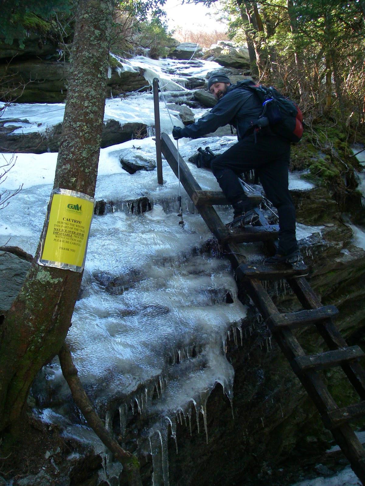
After reaching the top of Attic Window Peak, we headed down the Class 2 chute (maybe Class 3 with ice) on its west side, then through the short underground section where the trail goes beneath a huge jumble of room-sized boulders that have fallen off the cliffs over the millennia. The most formidable section of trail turned out to be just ahead, on the climb up MacRae Peak, a.k.a. Raven Rocks. Just above the gap, a short ladder scales a low cliff at the bottom of a steep slab of bare rock. There is a rubber-covered steel cable with knots in it, anchored on both ends, to act as a handrail of sorts on this, an appropriate safeguard for when the rock is wet. It seemed totally inadequate, even laughable, for the several inch thick layer of clear ice that plastered the rock today. You wouldn’t fall to your death here, but it wouldn’t feel good either. But we were game, and again had no problems. Amazing what you can do with the right gear! We were careful nevertheless. We actually met a guy coming down this with no spikes, but he certainly was envious of ours, and we didn’t envy him. I have no idea how the guys we later saw in tennis shoes fared on this, but it couldn’t have been pretty or graceful.


Heading underground temporarily. Photo by Tommy Bell
Minutes later we were climbing the ladder onto the overhanging summit block of this spectacular peak, one that would probably be a short, but technical and exposed climb without the ladder. It has an airy feeling to it for sure, and the violently gusting wind only exacerbated that feeling, tending to make one avoid the edges. But the views are simply superb, with the wild cliffs of Attic Window Peak close by on one side, and the almost exotic forms of Hawksbill and Table Rock off in the distance to the other direction. Of course, you have to take the good with the bad. This summit also gives one of the closest views of that monstrosity of a condominium on nearby Sugar Mountain that blights so many other summit views in this part of North Carolina, an eyesore that, in my opinion, should never have been built. But what’s done is done, and I find I can usually ignore it. Actually, I am often amazed at how far away it can be seen from, and sometimes use it as a very distinguishable landmark when trying to identify other nearby peaks.

Icy trail up MacRae Peak. Photo by Tommy Bell

Topping out on MacRae Peak. Photo by Tommy Bell
Attic Window Peak from MacRae peak.
Tommy on an overhanging outcrop on MacRae Peak
We had one final view of MacRae Peak.
We decided to skip the high ladders and more cables that descend the south side of the peak, followed by looping back around the west side on the Undercliff Trail. No doubt it would have been spectacular, maybe even scary, but we opted to simply backtrack from here, satisfied with the day. Headed back down the Profile Trail, we stopped briefly at Shanty Spring to admire the large icefall there and poke around at the nearly invisible beginning of the long abandoned Shanty Spring Trail, the route I used on my very first visit here back in 1991. A little farther and the trail of ice began to disappear.
The Profile, Haystack Rock, and Calloway Peak.
Even as I write this a month later (way behind on my blogging), similar conditions still persist on this amazing mountain. As of March 23, the state park website offers these warnings, tempting me to head there again, to the trail of ice, before Winter really is gone:
> 3/24/13 Fresh snow and ice. Trails remain slick.
> Please be advised: even with warmer weather, higher elevation trails will still have slick conditions for some time. There is still snow and ice below Calloway Peak and to Grandfather Mountain Attraction with intermittent deep snow drifts along the ridge line. Proper gear and clothing, adequate food/water and winter hiking experience are necessary for hiking at higher elevations. Caution: Ice traction is essential. Be alert to ice, snow and possible downed tree limbs on the park's trails.

Some of the trails on Grandfather Mountain. To view a larger map click here.

Hike Stats:
7.7 miles, 3,050' cumulative elevation gain via profile trail and back

Pictures from this hike
Pictures from other hikes to Grandfather Mountain
July 2011
July 2008
June 2007

Resources:
gpx files and maps
North Carolina State Parks Grandfather Mountain site
Grandfather Mountain State Park maps and directions
Grandfather Mountain private attraction site
SummitPost page - has additional links for each peak and routes


View Larger Map
Profile Trailhead coordinates:
36.12175,-81.83009

Google map for trailhead

Scan QR code to navigate to trailheads with Google Maps on your smartphone

Saturday, December 1, 2012

Elk Knob and Snake Mountain - Plus A Few More

A spectacular overhanging outcrop on Snake Mountain.
I had considered going to Grandfather Mountain on my next hike but quickly changed my mind when I got a text the night before from my peakbagging buddy Peter Barr. He was in the final stages of writing his second book, a guide to the Highest 100 peaks in the Southeast, and needed to get some up to date info on Elk Knob and Snake Mountain in Northwestern North Carolina. He also wanted to try bagging a few new peaks in the area and wondered if I would be interested in joining him. Since we live three hours apart and don't get to hike together very often - and the peaks he mentioned were even closer to me than Grandfather, it was a no-brainer to accept.

I first met +Peter only three years ago, though I knew of him for somewhat longer as being the second person to complete the list of 136 Southern Fivers (the peaks in the Southeast over 5,000' in elevation and having at least 300' of prominence - and he also did the remaining 64 peaks with 200' of prominence that is the standard in the Northeast), and through his first book, Hiking North Carolina's Lookout Towers. That led to some correspondence with him about a couple of the towers, as well as about a couple other peaks I was interested in that I knew he had been up. One thing led to another and we eventually met up for a hike when we realized how much of an obsession with mountains we had in common. Now we share a friendly competition trying to stay ahead of each other in the number of peaks we have visited in our respective states of Virginia and North Carolina, and get together for a hike whenever possible. In fact, we recently spent a week in the Adirondacks of New York and he also completed the Northeastern Fivers on Mount Marcy while we were there.

Three Top Mountain and The Peak.
Back to the hiking now. Before we got to the priorities at hand, we spent a few hours getting to the top of five other peaks first. I'm not going to go into detail about them because of access issues but will simply say that they were all over 4,000', new to both of us, and two of them had great views. One gave us a spectacular early morning scene of ragged Three Top Mountain and The Peak, while the other had amazing close up views of the sharp crest of Snake Mountain looming dauntingly above us. And to get a bit geeky and reveal the depth of our obsession, I should mention that four of the five peaks are among the Highest 500 in North Carolina, while the other one would have been were it not entirely in Tennessee. The lowest one was 4,100' and ranks as only the 413th highest in North Carolina. If it were in Virginia, it would be tied with six other peaks for the Number 61 spot. By the time we finished climbing these peaks, Peter's tally stood at 298 of the North Carolina Highest 500 climbed. For some reason I can't resist getting in a little jab and mentioning that I have been on 307 of Virginia's Highest 500....a lead that probably won't last long after Peter reads this. ;-)

Snake Mountain looming above.
By now, I was beginning to question whether or not we had enough time left for both of the remaining two hikes but we headed for Elk Knob State Park, leaving my vehicle near the north end of Snake Mountain for later. Elk Knob is a hulking, steep-sided dome in the heart of the Amphibolite Mountains, an often spectacularly rugged subrange of the North Carolina Appalachians that also includes Snake Mountain and such other particularly noteworthy mountains as Three Top and The Peak - a name that does not seem at all pretentious when the mountain is viewed from certain angles. In fact, several of these mountains are so impressive that they rate among the most rugged and dramatic in the Southeast, giving such places as Grandfather Mountain and Linville Gorge some serious competition. Yet, with the exception of the two state parks here (the other being Mount Jefferson), they are relatively unknown to most hikers. Most are privately owned but there are also some state game lands and a Nature Conservancy Preserve.

I would have preferred to gone up the old jeep trail that leads to the summit, a steep and direct route that is quite a grind to climb, but there is a new trail that was still under construction the last time either of us was here. Peter needed to be able to describe that trail accurately from the perspective of someone going up it, so that is the way we went. While I thought the old trail was more than adequate and even have a certain affection for it (that whole steep trails thing), I must admit the new trail is very nicely laid out, aesthetically appealing, and has a very moderate grade while still not milling around too much to get to the top - though its two mile length is about twice as long as the old route. But it also is not as much "fun".

Looking north from Elk Knob at The Peak, Three Top, and Bluff Mountain.
The 5,540' summit of Elk Knob is semi-open with only scraggly beech trees and small grassy areas and the views are wonderful. Close by are the rest of the Amphibolites which surround Elk Knob, including Rich Mountain Bald, Snake Mountain, The Peak, Three Top Mountain, Bluff Mountain, Phoenix Mountain, Mount Jefferson, and more. The high elevation Long Hope Valley lies directly below, a hanging valley of sorts, or about as close as the Southern Appalachians have to one. The more distant views include Grandfather Mountain, the Roan Highlands, Mount Rogers - and even the Blacks and Pilot Mountain on very clear days. It's a really great spot but it was getting late in the day so we didn't have time to linger properly.

We hiked back down the short, steep way on the old jeep trail and hopped in Peter's truck to go the last few miles to Rich Mountain Gap. From here it's only about 3/4 of a mile to the 5,580' summit of Snake Mountain and about a 1,160' climb. But it's more interesting than that. There is no trail, at least in the constructed sense. A faint path leads, Northeast style, straight up the fall line of the South Ridge. And 1,000' of that gain takes place in the first half mile. It is steep! And fun! And slow. Near the top of the climb, the route breaks out into the open on a narrow spine of rock that requires some mild scrambling and leads to ever wider views. Rich Mountain Bald is just to the south and Elk Knob is less than two miles to the east.
Elk Knob from the south shoulder of Snake Mountain.
The climb reaches a shoulder and the grade eases off dramatically for the last 1/4 mile to the top, but the views and drama just keep getting better for the next mile and then some. Though there are usually trees around blocking the view to one side or the other, much of the high crest is semi-open with frequent rock outcrops and panoramas. The ridgeline also gets quite narrow in many places, at times being a knife-edge only a couple feet wide with a steep slope on one side and a cliff on the other. While there isn't anything difficult about this section, there are a few spots where you want to pay attention to where you are walking. There is a path on the crest beyond the south shoulder and it occasionally avoids difficult bits of the ridge by dropping down a few yards to one side or the other but always goes back to the scenic top. As far as peakbagging goes, the summit is a P2K with 2,280' of prominence - one of only 25 peaks in the entire Southeast to break this threshold. This highpoint is entirely in North Carolina, but the state line follows the crest just to the north. There is a minor rise along that section to a narrow, pointy summit that is the Johnson County, Tennessee highpoint. The approach to that area,


Narrow ridge on Snake Mountain.


and especially the descent off the other side, is the most spectacular section of the hike and though it may not be quite as gnarly as the best part of Three Top, it is stunningly scenic and certainly one of my favorite places in the Southeast, quite possibly in my Top 10. And something that made it even better this time was the fact that Peter had never been beyond the county highpoint. It was a kick just seeing him be wowed by this section for the first time.

There are some abrupt dropoffs and the trail is forced to skirt around a couple of them, very steeply so at times. It quickly becomes wide open just below the north shoulder and the route moves onto bare rock and grass for the remainder of the descent. There are "wow" views behind at what we just came down and more "wow" views of the route ahead, not to mention great views of The Peak, Three Top, and lots more. It's a trek to savor and we made the final descent to my waiting vehicle in twilight, having made full use of the day.

The north summit of Snake Mountain and it's rocky spine.

The route of this hike. To see a larger map click here.

Hike Stats:

Elk Knob
3 miles
940' elevation gain

Snake Mountain
2.75 miles
1,400' cumulative elevation gain

More pictures from this hike

Pictures from other hikes to Elk Knob and Snake Mountain:
November 2009
February 2009
May 2008

Resources and contacts:
Elk Knob State Park
Elk Knob State Park Map & Directions
Elk Knob SummitPost page
Snake Mountain SummitPost page
gpx file and topo maps

Trailhead Coordinates:

Elk Knob 36.33206,-81.68962

Snake Mountain (North) 36.34283,-81.69667

Snake Mountain (South) 36.32096,-81.71037

Google map for trailheads:
http://goo.gl/maps/jf4mD

Scan QR code to navigate to trailhead with Google maps on your smartphone: