Friday, December 28, 2012

Balsam Cap & Friday Mountain - Snowshoeing In The Bushwhack Range

 
The Devils Path peaks from Balsam Cap
The Bushwhack Range! The name alone evokes thoughts of adventure, and maybe also of difficulty and a little apprehension. I had thoughts of all three running through my head as I pulled into the parking area on Moonhaw Road, much later than I should have the day after a significant storm had moved through the region. There were some low clouds lingering on my peaks of choice and nowhere else, of course, but it seemed likely they would dissipate. This unofficially named subrange of the Catskills contains four of the fourteen trail-less peaks required for the Catskill 3500 list, and they are among the most difficult ones.  Even though I do a lot of off-trail hiking at home, I have unintentionally, or perhaps subconsciously, left most of the trail-less Adirondack 46ers (8 of 9 remaining) and Catskill 3500 peaks for last in my quest to complete those two peakbagging goals. Of the twenty peaks on that particular Catskill list I had done so far, sixteen have been trailed and two more have unmaintained trails. With still twelve trail-less peaks to go and only three trailed ones, I figured I had better get cracking on the former. Deciding I may as well do the hard ones first, I came here.

There are many ways to get these four peaks. One very challenging hike I would love to try sometime in the future would be a big 17 mile loop from Neversink Valley, up the trail to Table Mountain, then traversing across the four trail-less peaks to Cornell, to complete the loop on the Wittenberg-Cornell-Slide, Curtis-Ormsbee, and East Branch trails. This would be an AWESOME seven peak day. If things were going well, it would be great to also add side trips to Peekamoose and, especially, Wittenberg for a twenty miler that might rival doing the Devils Path in a day, even though it would be fewer miles and less elevation gain. But I was not arrogant enough to think I could do this in the snow during the short days of Winter, solo, and with no familiarity of the off-trail sections. Actually, I was probably pushing things a little by starting the hike up Balsam Cap and Friday at noon, but that was the earliest I could get here and it was the last day I had with a good weather forecast. Besides, the round trip is only around seven miles - how hard could it be? Harder than anticipated, that’s how hard. I knew it would be steep, partly trail-less and thick, have nearly 3,000’ of cumulative elevation gain, route-finding issues, and snow to deal with. But I’m a reasonably strong and experienced hiker - surely I could do it in five hours, right? Wrong.

Given my late start, I had kind of hoped that there would be a group ahead of me to break trail, but no such luck. There was about a foot of fresh, untracked snow on the ground as I started up the steep woods road that eventually gains Friday’s eastern ridge. At first, it seemed quite powdery and easy, but after gaining a couple hundred feet in elevation it became obvious that I needed to stop and put on snowshoes. Things had just gotten slower. I was unfamiliar with the route, but a couple of times it seemed like the old road was going the wrong way, or too far out of the way, and I would simply head straight uphill and soon hit it or another road again. Eventually I wearied of sidehilling and guessing whether to stay on the road or not, so I just beelined it for the ridge crest and another road which I followed most of the way to the hunting cabin before I skirted left of the private inholding.  Once around the cabin property and back on the ridgeline, I continued my upward tromp, eventually encountering vertical ledges. At this point, I started angling off the ridge and sidehilling upward toward the Balsam Cap-Friday col, at times on what appeared to be a path - though it was very indistinct and hard to be sure of since it was buried under 18-24” of untrammeled snow. At times, both on this sidehill traverse, and on steep slopes higher up on Friday, the firm snow would fracture several feet away from me as I stepped on it, letting out an audible “whoomf” and sliding down the hillside several feet or yards, occasionally taking me with it for a couple of feet. If I had been on an open slope, I think I might have even been a little worried about causing an avalanche. Here though, the trees pretty quickly stopped it. Regardless, in places I was essentially wallowing as drifted snow kept sliding out from under me. Progress slowed again.


Just beneath the col, I wandered back and forth a bit before finally finding a reasonable, though still not easy way through more ledges. No doubt I missed the preferred route, if there is one. I was happy to finally reach this gentle saddle and have most of the climbing behind me. But it had taken far longer than 2 ½ miles normally should. That was o.k. because I would surely make up for it now as I headed for Balsam Cap. Wrong again.

Now I got to deal with the thick balsams that these peaks are known for. While I didn’t think they were hideous, certainly nowhere nearly as bad as the worst I’ve been in, they were indeed dense and with their fair share of downfall to negotiate. I found no sign of a herd path as I forced a sinuous route southward. Several times on these two peaks my showshoes caught branches under the snow and tripped me up. Also, the spruce were plastered with snow and it was nearly impossible to get through them without knocking it off the low hanging boughs and dumping it on myself. It didn’t take long to get quite wet, especially since I didn’t want to shred my rain gear on the sharp branches and was only wearing a polypro top. While I had plenty of extra clothing, putting it on while in the spruce would have only gotten it wet too. This meant I needed to keep moving to stay warm.  More slow going and some growing concern about the rapidly advancing time had another undesirable effect as well. It meant I couldn’t spare a lot of time searching for the canisters on the summits.

Ticeteneyck Mountain and Ashokan Reservoir from Balsam Cap
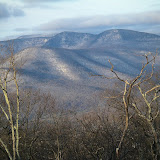
The great view northeast from Balsam Cap.
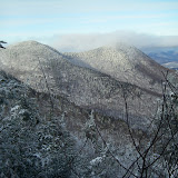
A snowy Cornell and Wittenberg from Balsam Cap
A couple hundred yards northwest of the summit, I found the viewpoint, or at least a viewpoint. Though limited in scope, it was quite nice and I was impressed by the great view of the eastern Devils Path peaks, as well as the ridge of my ascent, Ashokan Reservoir, and the Hudson Valley. I also thought the view of Ticeteneyck, which I had climbed a few days earlier, was pretty interesting. Lingering longer would have been great, but I restrained myself to enjoying the spot for a few minutes then pushed on to the summit. After milling around a few minutes I found the canister, signed it, and headed for Friday Mountain with 3 p.m. fast approaching.


Canister on Balsam Cap
 Back across the col and starting up Friday Mountain, I realized I had lost a snowshoe. This required backtracking a couple hundred yards to find it, and more time lost. I was unsure of the best way up Friday, but I knew it had cliff bands to contend with. No doubt, my route left a lot to be desired and was not the best way. After gaining perhaps 200’ of elevation above the col, I hit the base of some pretty high overhanging rock faces covered with ice. Unsure of the best way to go, I headed east, being forced to lose a little elevation in the process and losing more time to boot. After a few hundred feet I found a spot where it looked like it might be possible to get up a gully through the cliffs. It was very steep and there were a couple of somewhat exposed ledges, made a little sketchier by the sliding snow I encountered once again, but there were also just enough trees to be helpful and my route did, in fact work to get me above the cliffs. I wasn’t particularly looking forward to the descent though.


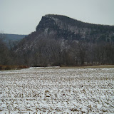
Formidable cliffs on Friday Mountain
 It was getting uncomfortably close to 4 p.m. as I topped out on the summit plateau. I had already accepted the fact that I would be finishing in the dark, but I wanted very badly to have the cliffs, spruce, and the col behind me before darkness fell. I had an old waypoint for the canister location, which was not the true summit. I seemed to remember having read somewhere that it had been moved to the actual summit but I decided to quickly visit the old site first. I hit the high ground there but didn’t see any sign of the canister, so I headed for the 3,694’ spot elevation in the center of the highest contour on the topo map. There was an obvious rock a few yards north of this spot that appeared higher, so I touched that and didn’t see anything that looked higher nearby. I didn’t see the canister though, so I did a little semi-circle around the spot elevation and touched any spot that seemed like a contender for the summit. I feel I had to have come within yards, if not steps, of the canister, but judgement overcame desire and I turned around and headed down at about 4:15 p.m. - with sunset  approaching and at least an hour later than I would have liked.

The descent from Friday was actually pretty easy excepting for one or two spots, and I was able to sort of glissade off several small ledges and steep sections with the snowshoes adding both flotation and braking. Escaping the col was even easier, and I made it across the sidehill traverse back to the east ridge in rapidly fading light. Following my own tracks, routefinding was no longer an issue, at least not until it got darker. I had stubbornly resisted stopping to get my headlamp out, but eventually my tracks became very difficult to see and I started worrying about getting a branch in the face or worse. I turned on the light about a mile from the end and suddenly my tracks were glaringly obvious, even more so than they had been while it was still light. I think I was able to actually go faster and made it back to the trailhead from the summit of Friday in just over 1 ½ hours compared to the 3 hours and 10 minutes it had taken me to get to Balsam Cap. The day hadn’t gone quite the way I would have liked it to have, but I was still pretty satisfied with it and the feeling that most of the remaining peaks for the Catskill 3500 will probably be easier - unless I try that big loop to get Lone and Rocky.


The route of my hike (not necessarily the best route) to Balsam Cap and Friday Mountain. To see a larger map click here.


Hike Stats:
7.4 miles
2,800' cumulative elevation gain


Balsam Cap & Friday Mountain, NY
Pictures from this hike

Resources:

gpx files and topos
Balsam Cap - Catskill 3500 Club
Friday Mountain - Catskill 3500 Club 
Catskill Hiker
Catskill Mountaineer

Trailhead Coordinates:
41.98373,-74.32693

Google map for trailhead 

Scan QR code to navigate to trailheads with Google Maps on your smartphone
:


Wednesday, December 26, 2012

Vromans Nose and Plotter Kill Falls - A Few Hours In The Helderbergs And Mohawk Valley


Upper Plotter Kill Falls
After having known for several years that there were some interesting areas on the Helderberg Escarpment of New York, I finally had a chance to briefly check out a couple of them this past October while enroute to the Adirondacks from Virginia.

It was nearly dusk when my buddy +Peter Barr  and I made it to the Indian Ladder trailhead in John Boyd Thatcher State Park on that trip. We had just enough time to get to the base of the spectacular 116' plunge of Mine Lot Falls while there was still enough light to see it and take a few pictures. Then we drove up the nearby high point of the eastern escarpment in the dark, mainly just to say we had been there.

That was enough of a taste to convince me that some of the other nearby places I had read about would also likely be worth getting to sometime. As luck would have it, that sometime was now, less than three months later. Leanne wanted to visit two of her cousins living near Albany. I would only have a few hours to spare, but that would be better than nothing.


The trail atop Vromans Nose hugs the edge of the cliffs.
Overlooking the Schoharie Valley.
After dropping Leanne off, I headed west to Middleburgh and Vromans Nose. This is a small but very impressive peak that rises abruptly 600’ above the flat valley of Schoharie Creek. Less than a mile up an icy trail and I was atop the dramatic cliffs that line its south side. While the local landscape here generally may not be as breathtaking as the Adirondacks or the Catskills, the scene is a pleasing one as it looks down precipitously to the broad, flat rural valley below. In turn, the valley winds its way southward into the surrounding hills of the Helderbergs. Off in the distance are visible a couple peaks in the Moresville Range of the Catskills. Supposedly Windham High Peak and the magnificent Blackhead Range are also visible from here, but haze and cloudiness prevented that today. The trail itself is right on the top of the cliffline, disconcertingly so in a few spots when it is snowy and icy like it was today, and it stays there with continuous views for about 3/10 of a mile. I’m not sure how high they are, but 150’-200' or more wouldn’t surprise me in a couple of areas, and the edge is a straight plunge - no ledges a few feet down. In fact, it almost seems that you would land on the road 600’ below if you jumped. The clifftop is also wide and flat, especially near the western end, which is known as the Dance Floor. Apparently, there actually were dances here back in the Prohibition era. Hopefully no alcohol was involved because there are no barriers whatsoever to the cliff edge.

Vromans Nose
 After completing the short loop, I drove several miles north to near the Mohawk River and a few miles west of Schenectady. Here, the waters of Plotter Kill and Rynex Creek have carved a two mile long gorge that drops several hundred feet. The result is more than a dozen waterfalls. Most are small, but there are three large falls near the upper end of the gorge.

I started at the upper trailhead, above the larger falls and followed the icy trail downhill and across the creek to the top of the Upper Plotter Kill Falls. They were quite impressive and mostly frozen - though I was a little skeptical that they were 60’ high as claimed in the guidebook. I would have guessed 40, maybe 50 feet. Regardless of their height, they presented a scene of great beauty as the stream poured over the brink and poured into the rock walled amphitheater below. I continued down the trail along the rim until I was able to catch a glimpse of the 40’ high Lower Plotter Kill Falls and Rynex Creek Falls as well. I considered trying to descend the narrow, very steep ridge between these two falls to get a better view from below but decided against it when I found it to be quite icy and having some dropoffs lower down. I settled for backtracking a short distance and taking the trail down to the creek between the upper and lower falls. From here it was easy to continue upstream to the base of the upper falls for a better view. From this vantage it was easier to see the entire cataract and the masses of ice it had built up. The spray had also encased the trees immediately downstream, its weight bending their branches over the frozen stream like bowers. It was a scene of great beauty, mostly in black and white, that I left behind as I made my way back up the trail wishing I had time to explore a little while longer.


The route of the Vromans Nose hike. To see a larger map click here.


The route of the Plotter Kill Falls hike. To see a larger map click here


Hike Stats:
Vromans Nose - 1.5 miles, 500' elevation gain
Plotter Kill Falls - 1.4 miles, 150' cumulative elevation gain


Vromans Nose & Plotter Kill Falls, NY

More pictures from these hikes


Resources:
Local Hikes - Vromans Nose
Local Hikes - Plotter Kill Preserve
Hiking The Plotter Kill Preserve
Vromans Nose (gpx, kml, topos)
Plotter Kill Falls (gpx, kml, topos)

Trailhead Coordinates

Vromans Nose: 42.59474,-74.3584
Google Map for trailhead

Scan QR code to navigate to trailheads with Google Maps on your smartphone:


Plotter Kill Falls: 42.82567,-74.05187
Google map for trailhead

Scan QR code to navigate to trailheads with Google Maps on your smartphone:


Monday, December 24, 2012

Ticeteneyck Mountain and Carl Mountain - Pursuing the Catskill "35 Finest"


Whenever I’m lucky enough to be in the great state of New York, I feel like I have to get out and explore the mountains every chance I possibly can, both because they are so awesome and because I have so few opportunities. That’s not too hard, since the only times I’m likely to be there are on a hiking vacation or at Christmas. During Christmas visits, excepting for really bad weather, there are usually only one or two days I can’t get out for at least a short hike, if not all day. No matter where Leanne needs to go on a certain day to visit family, I’m likely going to be close to the Catskills, the Gunks, the South Taconics, the Hudson Highlands, or even the Helderbergs or the southernmost Adirondacks. This year on Christmas Eve, I was free until mid-afternoon, more than enough time to go bag a peak or two from Kingston.

One peak that caught my eye a few years ago was Ticetonyk Mountain, as seen from the causeway across Ashokan Reservoir, a rather remarkable spot for mountain views. The shape of the peak was pleasing and the curious name had a certain appeal as well. I assumed it was a Native American name at the time, but had no idea what it meant or how to pronounce it. At an elevation of only 2,510’, it’s no high peak, even in the Catskills. But it has 1,640’ of prominence, which is more than all but six of the Catskill 3500 peaks. That means it towers above its immediate surroundings quite a bit and is a very significant peak in its own right. In fact, it is the eighth most prominent peak in the whole range. A nice complimentary list to the Catskill 3500 is known as the Catskill 35 Finest, with “Finest” being an accepted moniker among peakbaggers for “most prominent”. On that list of 35 Catskill peaks, only 19 are P1Ks, having at least 1,000’ of prominence. Ticetonyk seemed like a good way to make progress on that list with my limited time, and there was another nearby peak that would allow for even more if all went well.


I had been unable to find much information about this peak before the trip, but I knew from the Trails Illustrated map of the Catskills that the summit area was on state lands and there appeared to be a narrow, convoluted corridor or right-of-way for access. A bit of time beforehand on the Ulster County GIS site and Google Earth let me work out an accurate route to keep my access legal. I also made note of a potential viewpoint from the aerial imagery. Having done a quick drive-by of the access point a year earlier, and talking to a couple of the locals, I felt confident that I wouldn’t have any trouble with access, despite the very abundant “No Trespassing” signs along Peck Road. Sure enough, there was even a sign that I hadn’t noticed last year at the small parking area., It proclaimed that these were state lands for “Ticeteneyck Mountain”. I was pleased to see that there were frequent markers for the corridor, as well as a faint path. The route came quite close to a couple of houses or other structures a short distance in but there were no vicious dogs or other warnings against wandering out of the corridor, which I in fact did at the point where I needed to start going up, mainly to simply avoid getting any closer to one of the houses. Nevertheless, the corridor would seem to be open to public access.

After gaining a couple hundred feet of elevation, I hit an old woods road going uphill in an acceptable direction toward the crest of the South Ridge. I followed it, wandering a very short distance outside the boundary line, then back to it right on the ridgeline. At this point the road seemed like it was going to continue sidehilling to the northwest, so I left it and began heading straight up the ridge in open woods. It was somewhat steep at first but eased up until around 2,250’, at which point it climbed steeply once again. Like before, this was short lived and I hit a terrace at 2,400’. I had a suspicion about the steep contours at this elevation on the Southeast Ridge, and so I wandered the short distance there to find a wonderful reward. There is a small, open ledge here with grassy slopes around it and it allows a beautiful view over nearby Tonshi Mountain and Ashokan Reservoir to the wide Hudson Valley and the Shawangunk Mountains. Skytop is very obvious, like from countless other places in this part of Southern New York. In the far distance the South Taconics and Hudson Highlands were also visible. Through the trees I could also see Overlook Mountain and Ashokan High Point.

Curiously, despite the lack of info I had found about this mountain, its unclear access, and being trail-less and unmentioned in practically all the trail guides I own, the ledge had literally dozens of initials carved into it. Apparently, this is a well known and well visited spot, at least among some group of people - or it was at some time in the past.

It was only a short, easy stroll to the summit from here and I had no trouble finding the benchmark on one of the two large rocks there. It was plainly stamped “Ticetonyk”, just like the USGS topo says. Perhaps this is a corruption of the name “Ticeteneyck”, which itself may be a simplification.

Getting a bit ahead of myself here, but after getting back to Virginia at trip’s end, I spent some time online and made a couple of phone calls back to New York as well. As best I can determine, Ten Eyck is a local family name, Dutch in origin, and pronounced Ten●Ike (10●Ike). Tice (or Tys) was a member of that family. So I believe that Ticeteneyck is more likely correct and therefore pronounced Tice●Ten●Ike. Apparently the DEC agrees, based on the sign at the trailhead. Perhaps Ticetonyk is a variation on that and might be pronounced Tice●Tun●Ike?

Leaving the summit, I then headed a short distance west to investigate the potential viewpoint I had noticed on Google Earth. Sure enough, there was a rather large ledge here, perhaps 30’ high. It was partially screened by trees, but by moving around a little it was possible to get some great views of all the peaks from Panther Mountain to Peekamoose, including Giant Ledge, Wittenberg, Cornell, Slide, Friday, Balsam Cap, and the tiptop of Table Mountain. I don’t think Lone or Rocky were visible however.

Friday, Slide (background), Cornell, and Wittenberg from the west ledge on Ticeteneyck.


Above: Peekamoose, Table, Balsam Cap, and Friday from Ticeteneyck.
Right: Giant Ledge and Panther from Ticeteneyck.

After a few minutes of enjoying this second great spot and taking a few pictures, I backtracked down the mountain and decided I had just enough time for one more peak. It was only a few more miles to Carl Mountain, which is just north of Tremper Mountain. Since most of the hike would be on the 1.6 mile long Willow Trail, I figured I could blaze up that and then only have a modest bushwhack to the summit to slow me down. Carl is yet another P1K, the 19th most prominent peak in the Catskills and the least of the P1Ks with 1,020’ of rise above the ridgeline saddle that connects it to Plateau Mountain, which is its line parent.

I encountered a sign near, but before, the trailhead warning that it was a private road, so I was unsure where to park. Thinking I might have missed it, and that a roadwalk was required to reach the actual beginning, I drove back to the previous intersection where there was a DEC sign showing the distance and direction to the trailhead. Sure enough, I had been in the right place but couldn’t go far enough without driving past the warning sign. A woman who lived beyond the sign happened to be coming down the road, and after I talked to her, she told me that she regularly sees strange cars parked along the shoulder of the road before the sign and assumed they were hikers. She then, nevertheless, gave me permission to park near her house just beyond the sign. I misunderstood where she told me to park and ended up at the trail’s beginning, so I simply pulled up into a small meadow there beside the trail and just off the road.

Peak 2,830 from Carl Mountain
The trail was a little icy, but it was indeed a fast walk to the Long Path at the gap between Peak 2,830 and Carl Mountain. I left the trail and headed northeast directly for the summit. The woods were a little brushy, but not enough so to cause any real trouble. There was also some crusty snow that I kept breaking through, but it wasn’t bad enough to make me regret not carrying snowshoes. Actually, I didn’t think it would be an issue because there was only a inch or so of snow on top of Ticeteneyck, and even that was spotty. A little perseverance and the 500’ climb from the saddle put me on top. I didn’t linger, but I was curious about the steep terrain on the Southeast Ridge, so I made my way there hoping to find some open ledges. Not finding much at the likely spot, I then sidehilled back to the west at around 2,700’. There was one small opening atop a cliff that had a screened view of Peak 2,830 but not much else. Not having time to do a more thorough exploration that would have combed the eastern face of the peak, I called it a day happy to now have 13 of the 19 Catskill P1Ks checked off (though only 37 of 123 in New York as a whole). But there was yet one more minor peak to the northeast that definitely caught my eye...

The route of the Ticeteneyck Mountain hike. To see a larger map click here.
For even more viewing options, including aerial with contours, click here.

The route of the Carl Mountain hike. To see a larger map click here.

Hike Stats:
Ticeteneyck Mountain: 4 miles, 1,450' cumulative elevation gain
Carl Mountain: 4.4 miles, 1,600' elevation gain

Ticeteneyck (Ticetonyk) and Carl Mountains, NY
More pictures from these hikes

Resources:
Ticeteneyck Mountain (gpx, kml, and kmz files, topo maps)
Carl Mountain (gpx, kml, and kmz files, topo maps)
Catskill Mountaineer post for Ticeteneyck Mountain

Catskill 35 Finest list, maps,and info on Lists of John:
List
Notes
Location and Completion Map
Lists of John Member Progress

New York State Prominence Info

Trailhead Coordinates

Ticeteneyck Mountain: 41.99062,-74.21409
Google Map for Trailhead
Scan QR code to navigate to trailheads with Google Maps on your smartphone:


Carl Mountain: 42.07797,-74.24318
Google Map for Trailhead
Scan QR code to navigate to trailheads with Google Maps on your smartphone:

Sunday, December 23, 2012

Giant Ledge & Panther Mountain

Looking Northeast from Panther Mountain.
Yesterday’s hikes up the Beacons and The Taurus in the Hudson Highlands were indisputably great and rewarding, but they also only reached a maximum elevation nearly 1,000 feet lower than home. I had aspirations to get higher than that on this trip, so some outings in the Catskills were also priorities. The weather forecast looked great, so today seemed like an ideal time to get a little more elevation. Since I am working on the Catskill 3500 list, that is climbing the 35 peaks in the range above 3,500’, anything over that elevation I hadn’t already been on would be a plus. Since it was a clear day, anything with good views would be another plus.
 

+Leanne was also free today, and wanted to get out for at least one hike during our week in New York. She wanted a good hike but didn’t want to do anything overly difficult, so I ruled out the remaining trail-less peaks which I had not yet been on. And since I’ve been considering leaving trailed Windham High Peak for last, that let me narrow it down to a very small handful of the trailed peaks I had not yet been on. Since views were highly desired - and I knew from a previous visit that Giant Ledge was spectacular, as well as along the route to Panther - it became a no-brainer as to where to go. Furthermore, Panther is one of four peaks that the Catskill 3500 Club requires to be climbed a second time, in Winter, to qualify for membership. Today was December 23, two days into Winter. Another plus! Not only that, but it would possibly be Leanne's first Catskill 3500 peak. Even though she grew up in Kingston, she only did a limited amount of hiking in the area. She may have done a hike up Slide with friends in her college days, but can't remember for sure. If not, this would indeed be her first 3500er, though we had done some other peaks like Tremper and Red Hill together.

We left the parking lot in upper Big Indian Hollow on an icy, snowy trail and began the 500’ climb up to the Slide-Giant Ledge col. The snow was shallow enough, and the ice sporadic enough, that barebooting it worked fine for this section, and indeed for the whole hike, with a couple of exceptions where perhaps microspikes would have been better put on than carried in the pack.

On the horizon, some of the Devil's Path peaks rising above Tremper Mountain.
The hiking was easy for a short stretch after reaching the col, but steepened considerably on the uppermost 300’ of Giant Ledge. I thought some of the snowy ledges to be great fun clambering up, and wished there had been a lot more of them. But the trail flattens out as it reaches the top of the long cliffline the peak is named for. Over the next couple thousand feet there are a number of great views to the east and northeast, but the very best is probably the first one. The top of the ledge is nice and wide here, and flat - with great places to just hang out and take in the wonderful views. Slide Mountain, the monarch of the Catskills as the range highpoint, is visible far to the right,  just through the trees, towering 1,000’ higher. Slide is the second most prominent peak in New York, with 3,295’ of prominence. Only the Adirondack’s Mount Marcy, with 4,925’ of prominence beats it. But Slide beats out Marcy to be the peak with the most isolation in New York, there not being a higher peak within 136 miles.  Then, in clear view, are Friday’s summit, and the entirety of Cornell and Wittenberg. Far to the left is the summit of Panther some 500’ higher. But my eye was drawn more to the northeast and the challenging up-and-down crest of the Devils Path peaks. West Kill, Hunter, Plateau, Sugarloaf, Twin, and Indian Head were all visible on the horizon, sharp-cut in the clear Winter air. A big goal of mine is to sometime hike the entire Devil’s Path over all these peaks in one day, a distance of some 22 miles and a cumulative elevation gain of 8,000’. This is one of three classic Northeast “Death Marches” (though still not the hardest that are done with some regularity by the hardcore hikers of the Northeast). The other two are White Mountain’s Presidential Traverse in a day, and the Adirondacks Great Range Traverse in a day. I did the former with my buddies Shane Ashby and Tommy Bell in a tough 18 hour day in 2010. My buddy Peter Barr and I attempted a variation of the Great Range Traverse last October but nagging problems from a prior injury forced us to bail out early. These latter two are longer and have more climbing than the Devil’s Path, but I’m not entirely certain they are any harder. I’d like to find out.

Fun ledges enroute to Panther Mountain.
Continuing on, we descended steeply into the Giant Ledge-Panther col then quickly started up again even steeper. I came close to pulling the microspikes out a couple of times, but the really icy sections were short and had enough firm snow adjacent to them that we were able to find sufficient footing. As the grade eased, it became less and less of a concern and we soon found ourselves in the beautiful snowy balsams the rest of the way to the summit.

Based on the criteria used by the Catskill 3500 Club, Panther Mountain, at 3,720’ elevation, is the 18th highest peak in the Catskills. Club lists are great, and I like them for specific ranges or regions, but that is only one possible way of looking at it. If one uses an interpolated elevation of 3,730’ and considers only peaks with at least 300’ of prominence, it is tied with Balsam Lake Mountain for 12th highest in the Catskills and tied with Balsam Lake and Lewey Mountains for 65th highest in New York. Regardless of its ranking or elevation, or any other stat, it is a great summit with a couple of nice viewpoints. Not as open or expansive as those from Giant Ledge, they add the perspective of increased elevation, as well as extend it farther northwest to include peaks such as Sherrill and North Dome, two more I have yet to climb.

On the return hike up Giant Ledge.
After another enjoyable summit stay, we headed back the same way we came from, excepting a brief detour off-trail to tag the true summit of Giant Ledge, a viewless rock in the woods. Nevertheless, using the same criteria as for the Catskill 3500 peaks, this 3,200’ summit is one of the Catskill Highest 100 peaks and could not be passed up, especially since I can’t remember if I went to the actual summit on my 2005 visit. Peaks must be bagged!

One last view from Giant Ledge.

The route of the Giant Ledge and Panther hike. To see a larger map click here.

Hike Stats:
6.9 miles
1,900' cumulative elevation gain

Pictures from this hike

Resources:
gpx file and topos
Catskill 3500 Club
SummitPost
Catskill Hiker
Catskill Mountaineer

Trailhead coordinates:
42.02650,-74.40399

Google Map for trailhead

Scan QR code to navigate to trailheads with Google Maps on your smartphone: