
The Gentry Creek Trail is one of the lesser known gems in the Tri-State area where Virginia, Tennessee, and North Carolina all meet. When combined with Rogers Ridge and Glenn Bald, it makes a great, little known hike of 14+ miles with lots of creekside walking, wildflowers in the right season, a great little two-tiered waterfall, and great views from a near 5,000' peak.
Though I've now done this hike several times, the one time I tried it with Tommy, we came in the Winter. The creek was frozen over and we gingerly walked across the ice at every one of the many crossings enroute to the waterfall, hoping not to fall through. It started snowing, and we decided against going up on Rogers Ridge that time. We were back for unfinished business today.
 |
| One of many crossings of Gentry Creek. |
Along with the beauty of the stream, we were also treated to the sight of lots of Dutchman's breeches and erect trilliums in bloom. Then, after about three miles, we finally reached the reward of Gentry Falls. This two-tiered beauty is always a nice sight, although getting a good picture showing just how neat it is proves difficult. It is impossible to get both falls in without a lot of foreground clutter and the crazy tilt of the rock strata always makes the picture look crooked even though it isn't. At any rate, there are two vertical plunges here. Both are around 20 feet high and separated by about 50 feet of horizontal stream. Actually, with the creek as full as it was today, the lower falls spill over the cliff's edge as two parallel cataracts of whitewater. This may be the first time I’ve seen more than a trickle coming off the left side, and it was quite pretty.
 |
| Dutchmen's breeches |
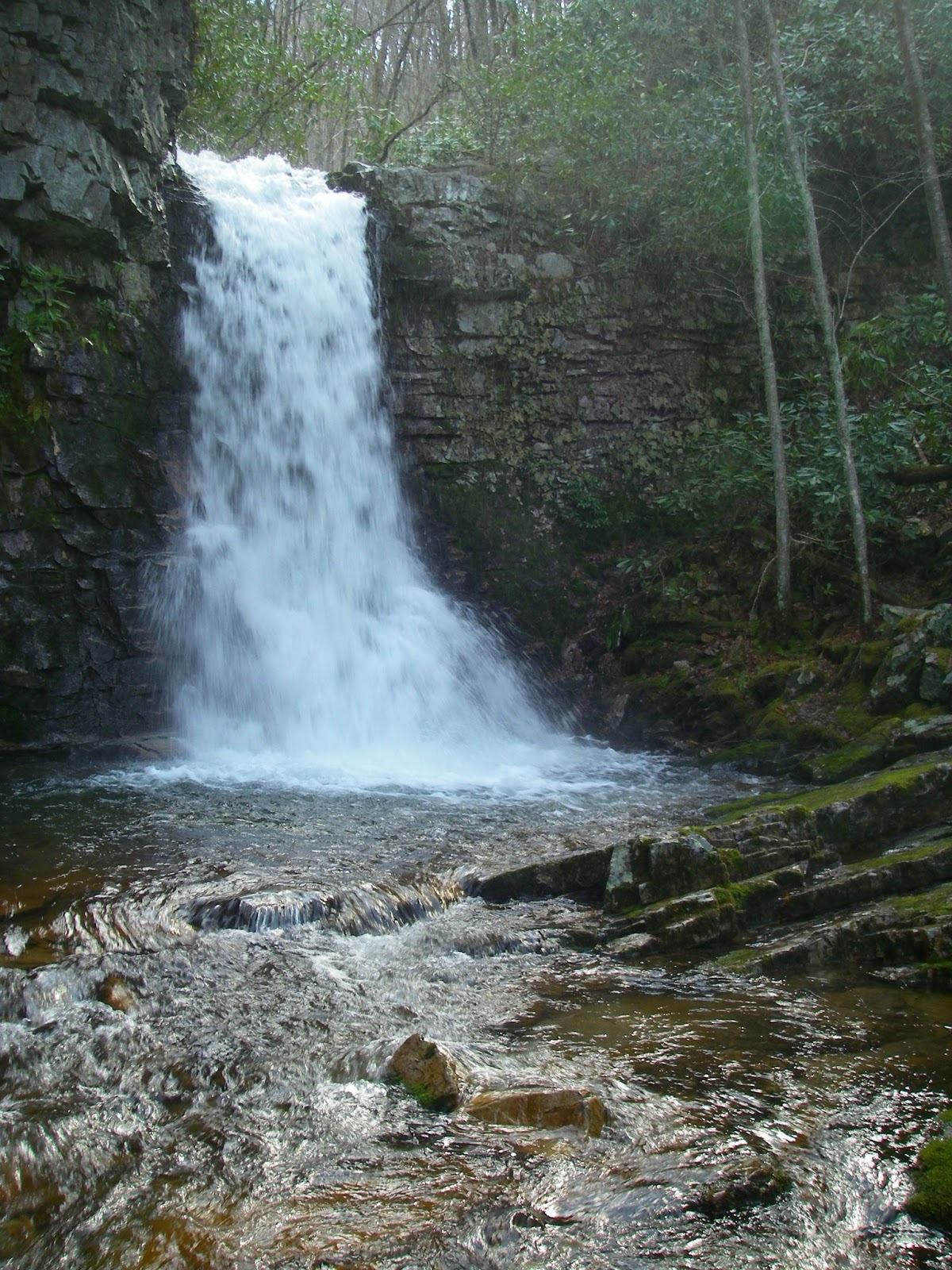 |
| Upper Gentry Falls |
 |
| Whitetop and Mount Rogers from the top of 4,980' Glenn Bald
Until recently, Glenn Bald’s top was private property, but it has now been bought by the State of North Carolina, and is public land. There is still a house on top, once very nice, but now badly vandalized by idiots. I have been told that one potential use for the house may be as some sort of outdoor education center. Today though, it was very windy and cold up here at nearly 5,000’, so the house made a great place to get out of the wind and eat lunch, all the while looking out the upstairs window at Mount Rogers and Whitetop. Back outside, the open top provides about a 270° panorama around the horizon, sweeping from Pond Mountain in the southeast, to Mount Rogers and Whitetop, the Iron Mountains, the distant crest of Clinch Mountain’s many peaks, then swinging southwest to include the Bald Mountains, the Roan Highlands, Grandfather Mountain, and several peaks in the Amphibolites, the most obvious being The Peak, Elk Knob, and Snake Mountain.
Our return route was to simply stay on the Rogers Ridge trail, parallelling the route we had followed up Gentry Creek, but several hundred feet higher until reaching the south end of the ridge, where the trail then descends back to the valley for one final crossing of the creek and the end of another great day in the Southern mountains.
|
 |
| Rogers Ridge (left) and Clinch Mountain (horizon) from Glenn Bald. |
 |
| Heading back down the open crest of Rogers Ridge. Gentry Creek lies in the valley to the left.
Gentry Falls-Rogers Ridge-Glenn Bald Loop. To view a larger map click here
Note: There seems to be a problem with the default map view I have selected not working. Please select the map you prefer from the drop-down menu in the upper right corner of the map.  Hike Stats: 14.3 miles, 2,800' cumulative elevation gain Pictures from this hike Pictures from other hikes to Gentry Falls, Rogers Ridge, and Glen Bald October 2011 March 2011 April 2008 Resources: gpx, kmz, and topos Appalachian Treks blog Blue Ridge NC Guide Sherpa Guides page Johnson County Trails Association |
View Larger Map
Gentry Falls - Rogers Ridge Trailhead Coordinates:
36.54491,-81.73866
Scan QR code to navigate to trailheads with Google Maps on your smartphone

This one's on the list...might be a good weekend for me and Brog. Anywhere to camp near halfway?
ReplyDeleteAnd what is it with idiots vandalizing stuff like this?
This comment has been removed by the author.
ReplyDeleteHi Bradley,
DeleteSorry I didn't respond sooner, but I was on a hiking vacation in the Adirondacks and White Mountains up North. To get to the upper falls from the lower, you cross the creek just below the lower falls and follow the base of the cliffline uphill until you come to a break in it. This will allow you to continue upstream, b ut just be aware that the rocks below the upper falls are slick and sloped in the wrong direction if you go down to the waters edge. To continue upstream, you can do a slightly exposed climb up ledges a few yards right of the upper falls that angles back toward them, or you can once again go uphill to the right a little ways and find an easier way past the cliffs.
As for the top of the trail, click on the gpx, kmz, and topos link above and under the Resources header. There you can look at or download either a jpeg or pdf of a map as well as a gpx file for a gps or a kml or kmz file for Google Maps/Google Earth.
Hope this helps!
This comment has been removed by a blog administrator.
ReplyDelete