Grandfather
Mountain is one of my favorite places, and always has been since my
first visit over 20 years ago. Its high balsam forest, wild weather, and
ragged, rocky crest with ladders and cables have always been a mental
transport to another favorite region the best part of a thousand miles
away, where such things are commonplace. It is arguably the most rugged
mountain in the Southeast, but agree or not, it would make most anyone’s
short list of contenders for the distinction. I can’t get enough of the
place, and try to visit, on average, once a year. After missing my more
or less annual hike on Grandfather Mountain last year, I was determined
to get there sometime this year.
 |
| Not a problem. Photo by Tommy Bell |
Before this hike, I was thinking Winter was winding down. I was kind of bummed about that, not because I love cold weather, but because I hate hot, humid weather, and also partly because I had just had the good luck to win a pair of crampons from the writer of another hiking blog I follow, Section Hiker, whose owner regularly tests and gives away gear. I figured it was going to be at least December before I would have a chance to try them out, on my usual Christmas visit to the Catskills. But, lo and behold, we had another wave of cold and snow, and I found out that the higher trails of Grandfather Mountain were supposedly very icy! My buddy Tommy had been wanting to return there as well, so it ended up being a no-brainer where to hike this weekend. I wasn’t really expecting to need full crampons for the hike, only my usual microspikes, but I figured I would at least have a chance to put them on and try them out somewhere. Well, there turned out to be far more ice than I would have ever imagined.
We
started up the Profile Trail on dry ground, and I had doubts about just
how much ice there was going to be. But around the 4,500’ elevation, a
little snow started to appear and the trail slowly became more and more
icy as it climbed higher and higher. We passed below the cliffs that
form The Profile, and the spectacular off-trail pinnacle of Haystack
Rock - a spot I have long wanted to visit. Since off-trail hiking is
frowned upon in the park, going there would be ill-advised, though I’m
certain a few people have found the appeal to get off the beaten path
too great, and have done so, especially when the reward is so obvious.
 |
| On Calloway Peak |
By
the time we reached the crest, traction devices were definitely a good
idea. The trail was mostly a ribbon of hard ice, with only intermittent
sections of dry or snow-only covered footbed. Even though I had
microspikes, I decided that I wouldn’t look like an idiot wearing full
crampons after all. Especially on the many of the steep, rocky sections,
the ice was heavy and treacherous enough that it was probably pushing
the limit for microspikes anyway. With my new footgear though, I could
feel the 10 steel points on each boot bite into the ice, and felt
remarkably sure-footed. I was able to walk on the ice in most places as
though it were dry ground, a liberating feeling.
 |
| Looking toward Attic Window Peak |
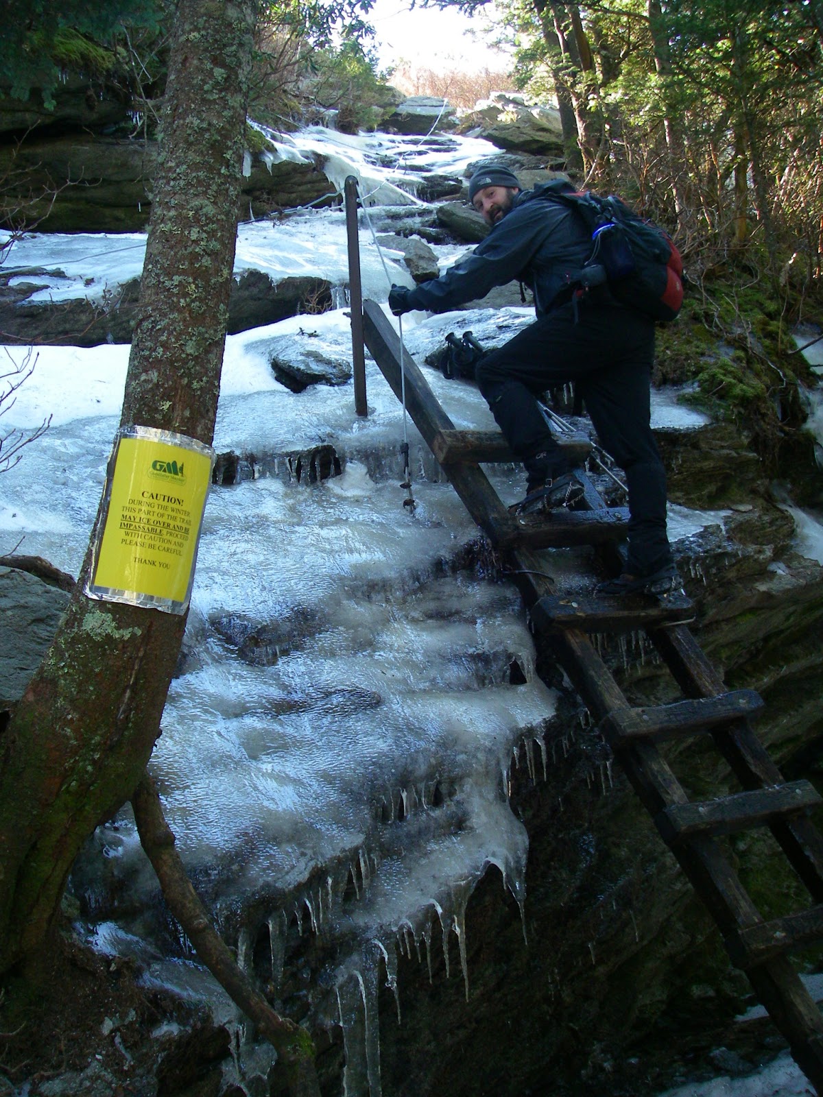
After
gaining a little more elevation and climbing a couple of short ladders
we made it to the 5,964’ summit of Grandfather Mountain, a.k.a. Calloway Peak.
The views from this highest point in the Blue Ridge are always great on
a clear day, as this was, and include the crest of the even higher
Black Mountains, the apex of these Eastern states. We took it all in for
a few minutes, then reversed our route back down into the gap to the
southwest to continue our icy trek.
The
terrain flattens out briefly beyond here, but soon enough we were back
on steep, ice-covered rock. There are definitely spots here where you
would not want to fall in Summer conditions, but that number increases
exponentially with ice because of the possibility of falling, then
sliding over something that you do not want to slide over. A good many
of the cliff faces up here are well over 100 feet high. Even if you
don’t go over a cliff, there is still the hazard of gaining momentum and
sliding into something, like another rock. Today it seemed that many of
the places you would least want ice had the most. But we were careful,
and had no real issues, only awe and great joy at being here on this
spectacular ridgeline of crags and wind and views.
 |
| Tommy below Attic Window Peak. |
After reaching the top of Attic Window Peak,
we headed down the Class 2 chute (maybe Class 3 with ice) on its west
side, then through the short underground section where the trail goes
beneath a huge jumble of room-sized boulders that have fallen off the
cliffs over the millennia. The most formidable section of trail turned
out to be just ahead, on the climb up MacRae Peak,
a.k.a. Raven Rocks. Just above the gap, a short ladder scales a low
cliff at the bottom of a steep slab of bare rock. There is a
rubber-covered steel cable with knots in it, anchored on both ends, to
act as a handrail of sorts on this, an appropriate safeguard for when
the rock is wet. It seemed totally inadequate, even laughable, for the
several inch thick layer of clear ice that plastered the rock today. You
wouldn’t fall to your death here, but it wouldn’t feel good either. But
we were game, and again had no problems. Amazing what you can do with
the right gear! We were careful nevertheless. We actually met a guy
coming down this with no spikes, but he certainly was envious of ours,
and we didn’t envy him. I have no idea how the guys we later saw in
tennis shoes fared on this, but it couldn’t have been pretty or
graceful.
 |
| Heading underground temporarily. Photo by Tommy Bell |
Minutes later we were climbing the ladder onto the overhanging summit block of this spectacular peak, one that would probably be a short, but technical and exposed climb without the ladder. It has an airy feeling to it for sure, and the violently gusting wind only exacerbated that feeling, tending to make one avoid the edges. But the views are simply superb, with the wild cliffs of Attic Window Peak close by on one side, and the almost exotic forms of Hawksbill and Table Rock off in the distance to the other direction. Of course, you have to take the good with the bad. This summit also gives one of the closest views of that monstrosity of a condominium on nearby Sugar Mountain that blights so many other summit views in this part of North Carolina, an eyesore that, in my opinion, should never have been built. But what’s done is done, and I find I can usually ignore it. Actually, I am often amazed at how far away it can be seen from, and sometimes use it as a very distinguishable landmark when trying to identify other nearby peaks.
 |
| Icy trail up MacRae Peak. Photo by Tommy Bell |
|
|
 |
| Topping out on MacRae Peak. Photo by Tommy Bell |
|
 |
| Attic Window Peak from MacRae peak. |
 |
| Tommy on an overhanging outcrop on MacRae Peak |
 |
| We had one final view of MacRae Peak. |
We
decided to skip the high ladders and more cables that descend the south
side of the peak, followed by looping back around the west side on the
Undercliff Trail. No doubt it would have been spectacular, maybe even
scary, but we opted to simply backtrack from here, satisfied with the
day. Headed back down the Profile Trail, we stopped briefly at Shanty
Spring to admire the large icefall there and poke around at the nearly
invisible beginning of the long abandoned Shanty Spring Trail, the route
I used on my very first visit here back in 1991. A little farther and
the trail of ice began to disappear.
 |
| The Profile, Haystack Rock, and Calloway Peak. |
Even
as I write this a month later (way behind on my blogging), similar
conditions still persist on this amazing mountain. As of March 23, the
state park website offers these warnings, tempting me to head there
again, to the trail of ice, before Winter really is gone:
> 3/24/13 Fresh snow and ice. Trails remain slick.
> Please be advised:
even with warmer weather, higher elevation trails will still have slick
conditions for some time. There is still snow and ice below Calloway
Peak and to Grandfather Mountain Attraction with intermittent deep snow
drifts along the ridge line. Proper gear and clothing, adequate
food/water and winter hiking experience are necessary for hiking at
higher elevations. Caution: Ice traction is essential. Be alert to ice, snow and possible downed tree limbs on the park's trails.
Some of the trails on Grandfather Mountain. To view a larger map click here.
Hike Stats:
7.7 miles, 3,050' cumulative elevation gain via profile trail and back
Pictures from this hike
Pictures from other hikes to Grandfather Mountain
July 2011
July 2008
June 2007
Resources:
gpx files and maps
North Carolina State Parks Grandfather Mountain site
Grandfather Mountain State Park maps and directions
Grandfather Mountain private attraction site
SummitPost page - has additional links for each peak and routes
View Larger Map
Profile Trailhead coordinates:
36.12175,-81.83009
Google map for trailhead
Scan QR code to navigate to trailheads with Google Maps on your smartphone