
Whenever I’m lucky enough to be in the great state of New York, I feel like I have to get out and explore the mountains every chance I possibly can, both because they are so awesome and because I have so few opportunities. That’s not too hard, since the only times I’m likely to be there are on a hiking vacation or at Christmas. During Christmas visits, excepting for really bad weather, there are usually only one or two days I can’t get out for at least a short hike, if not all day. No matter where Leanne needs to go on a certain day to visit family, I’m likely going to be close to the Catskills, the Gunks, the South Taconics, the Hudson Highlands, or even the Helderbergs or the southernmost Adirondacks. This year on Christmas Eve, I was free until mid-afternoon, more than enough time to go bag a peak or two from Kingston.
One peak that caught my eye a few years ago was Ticetonyk Mountain, as seen from the causeway across Ashokan Reservoir, a rather remarkable spot for mountain views. The shape of the peak was pleasing and the curious name had a certain appeal as well. I assumed it was a Native American name at the time, but had no idea what it meant or how to pronounce it. At an elevation of only 2,510’, it’s no high peak, even in the Catskills. But it has 1,640’ of prominence, which is more than all but six of the Catskill 3500 peaks. That means it towers above its immediate surroundings quite a bit and is a very significant peak in its own right. In fact, it is the eighth most prominent peak in the whole range. A nice complimentary list to the Catskill 3500 is known as the Catskill 35 Finest, with “Finest” being an accepted moniker among peakbaggers for “most prominent”. On that list of 35 Catskill peaks, only 19 are P1Ks, having at least 1,000’ of prominence. Ticetonyk seemed like a good way to make progress on that list with my limited time, and there was another nearby peak that would allow for even more if all went well.

After gaining a couple hundred feet of elevation, I hit an old woods road going uphill in an acceptable direction toward the crest of the South Ridge. I followed it, wandering a very short distance outside the boundary line, then back to it right on the ridgeline. At this point the road seemed like it was going to continue sidehilling to the northwest, so I left it and began heading straight up the ridge in open woods. It was somewhat steep at first but eased up until around 2,250’, at which point it climbed steeply once again. Like before, this was short lived and I hit a terrace at 2,400’. I had a suspicion about the steep contours at this elevation on the Southeast Ridge, and so I wandered the short distance there to find a wonderful reward. There is a small, open ledge here with grassy slopes around it and it allows a beautiful view over nearby Tonshi Mountain and Ashokan Reservoir to the wide Hudson Valley and the Shawangunk Mountains. Skytop is very obvious, like from countless other places in this part of Southern New York. In the far distance the South Taconics and Hudson Highlands were also visible. Through the trees I could also see Overlook Mountain and Ashokan High Point.

It was only a short, easy stroll to the summit from here and I had no trouble finding the benchmark on one of the two large rocks there. It was plainly stamped “Ticetonyk”, just like the USGS topo says. Perhaps this is a corruption of the name “Ticeteneyck”, which itself may be a simplification.
Getting a bit ahead of myself here, but after getting back to Virginia at trip’s end, I spent some time online and made a couple of phone calls back to New York as well. As best I can determine, Ten Eyck is a local family name, Dutch in origin, and pronounced Ten●Ike (10●Ike). Tice (or Tys) was a member of that family. So I believe that Ticeteneyck is more likely correct and therefore pronounced Tice●Ten●Ike. Apparently the DEC agrees, based on the sign at the trailhead. Perhaps Ticetonyk is a variation on that and might be pronounced Tice●Tun●Ike?

 | ||
| Friday, Slide (background), Cornell, and Wittenberg from the west ledge on Ticeteneyck. |


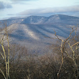
Above: Peekamoose, Table, Balsam Cap, and Friday from Ticeteneyck.
Right: Giant Ledge and Panther from Ticeteneyck.
After a few minutes of enjoying this second great spot and taking a few pictures, I backtracked down the mountain and decided I had just enough time for one more peak. It was only a few more miles to Carl Mountain, which is just north of Tremper Mountain. Since most of the hike would be on the 1.6 mile long Willow Trail, I figured I could blaze up that and then only have a modest bushwhack to the summit to slow me down. Carl is yet another P1K, the 19th most prominent peak in the Catskills and the least of the P1Ks with 1,020’ of rise above the ridgeline saddle that connects it to Plateau Mountain, which is its line parent.
I encountered a sign near, but before, the trailhead warning that it was a private road, so I was unsure where to park. Thinking I might have missed it, and that a roadwalk was required to reach the actual beginning, I drove back to the previous intersection where there was a DEC sign showing the distance and direction to the trailhead. Sure enough, I had been in the right place but couldn’t go far enough without driving past the warning sign. A woman who lived beyond the sign happened to be coming down the road, and after I talked to her, she told me that she regularly sees strange cars parked along the shoulder of the road before the sign and assumed they were hikers. She then, nevertheless, gave me permission to park near her house just beyond the sign. I misunderstood where she told me to park and ended up at the trail’s beginning, so I simply pulled up into a small meadow there beside the trail and just off the road.
 |
| Peak 2,830 from Carl Mountain |
The route of the Ticeteneyck Mountain hike. To see a larger map click here.
For even more viewing options, including aerial with contours, click here.
The route of the Carl Mountain hike. To see a larger map click here.
Hike Stats:
Ticeteneyck Mountain: 4 miles, 1,450' cumulative elevation gain
Carl Mountain: 4.4 miles, 1,600' elevation gain
 |
| Ticeteneyck (Ticetonyk) and Carl Mountains, NY |
Resources:
Ticeteneyck Mountain (gpx, kml, and kmz files, topo maps)
Carl Mountain (gpx, kml, and kmz files, topo maps)
Catskill Mountaineer post for Ticeteneyck Mountain
Catskill 35 Finest list, maps,and info on Lists of John:
List
Notes
Location and Completion Map
Lists of John Member Progress
New York State Prominence Info
Trailhead Coordinates
Ticeteneyck Mountain: 41.99062,-74.21409
Google Map for Trailhead
Scan QR code to navigate to trailheads with Google Maps on your smartphone:

Carl Mountain: 42.07797,-74.24318
Google Map for Trailhead
Scan QR code to navigate to trailheads with Google Maps on your smartphone:

Thanks for the report on Ticeteneyck mountain. I'll have to check it out sometime.
ReplyDeleteyour blog really look pretty. I like all the photos and specially the guidance map which shows all the tracks. i want to appreciateSullivan County Tourism for providing such a great opportunity.
ReplyDeleteThanks! Unfortunately I have managed to get far behind with it. I should have at least 8-10 more posts up with more coming in the Fall and Winter. Don't know how I'm ever going to get caught back up...
ReplyDeleteMy relatives own about half of Ticeteneyck Mountain and live on the shoulder of it still. The rock with the carvings in it is a place known to us a Two Views. Family weddings and memorials were held there with the family and friends hiking up to Two Views for the celebration. I remember as a child, decades ago, going there for a wedding and it was beautiful. I haven't been up there for decades but your hike description makes me want to visit it again. Thanks for sharing your experience.
ReplyDeleteThanks for the info on the name! I always like putting the local names with places if they don't have one on the map. Glad you liked the post. I really enjoyed going up there myself, and it seems this write up has stirred up at least some interest in it by other local hikers.
ReplyDeleteI know this is very long in the tooth, but I would like to ask Mike Johnson if his relatives are/were the Roarks. We're tracking down some of the history around Ticetyneyck Mountain, including Richard Hellman's (as in Hellman's Mayonnaise) ownership of some parts. Any other information about the area at all would be welcome. Our interests are strictly curiousity. And last weekend was our first trip to the top of Ticetyneyck, after an aborted trip last December. We just love the Catskills and the history that goes with it.
ReplyDelete